Location and physical setting
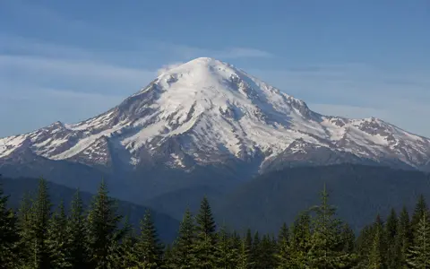
Mount Baker stands in Whatcom County, about 50 km east of Bellingham Bay and near the western margin of the North Cascades. It is the northernmost volcano in the contiguous United States. The cone rises above a dense pattern of ridges and glacial valleys rather than from an open plain, yet its broad snow-covered summit remains distinct from the sharper, older mountain terrain around it.
The volcano lies near the northern end of the Cascade volcanic arc, where subduction of the Juan de Fuca Plate beneath North America generates magma. Across the international border, this volcanic belt continues into southwestern British Columbia. Within Washington, Mount Baker lies north of Mount Rainier and Mount St. Helens, but its proximity to the Pacific and its northerly position give it an especially maritime, snow-rich setting.
Cone, craters, and older foundations
The present Mount Baker edifice began forming about 140,000 years ago and consists mainly of many andesite lava flows with volcanic breccia between them. Its main interval of cone growth occurred from roughly 40,000 to 12,000 years ago, and much of the upper cone is younger than about 20,000 years. Resistant lava layers form ribs and ridges, while glaciers and streams have removed much of the looser fragmental material.
Mount Baker is the youngest focus in a volcanic field active for about 1.3 million years. Jagged remnants of the Black Buttes stratovolcano stand against the southwest flank and expose an older cone built between about 495,000 and 288,000 years ago. These remnants show that the modern summit is only the latest high point in a volcanic landscape whose vents have shifted through time.
Carmelo Crater
A roughly 400 m wide, ice-filled crater crowns the volcano and is breached northward by Roosevelt Glacier.
Sherman Crater
This hydrothermally active crater lies about 400 m below and 800 m south of the summit.
Black Buttes
Eroded crags southwest of the cone preserve part of an earlier stratovolcano.
Glaciers across the volcanic cone
A broad mantle of glaciers and perennial snow covers the upper mountain. Coleman and Deming glaciers descend the western sector, Roosevelt Glacier breaches the summit crater on the north, and Park, Rainbow, Boulder, Easton, Squak, and other glaciers occupy valleys around the remaining flanks. Ice follows weaknesses and low ground between lava-built ridges, turning the cone into a radial pattern of white accumulation basins, crevassed icefalls, rocky divides, and sediment-filled meltwater channels.
Mount Baker has been affected by both alpine glaciers flowing from the mountain and continental ice advancing into the region. The Cordilleran Ice Sheet approached from the west and east before retreating from the area about 15,000 years ago. Repeated glaciation stripped away pyroclastic deposits, cut into older volcanic centers, and left isolated lava remnants and intrusive dikes. The visible landform is therefore partly constructive and partly erosional: eruptions built the relief, while ice exposed and reorganized it.
Nooksack and Skagit headwaters
Mount Baker and its surrounding volcanic field are drained by roughly 30 steep tributaries. Water from the north and west flanks enters forks of the Nooksack River, especially the Middle Fork below Deming Glacier. The Nooksack then crosses the lowlands west of the Cascades and reaches Bellingham Bay. On the east and south sides, meltwater enters the Baker River system, which flows through Baker Lake and Lake Shannon before joining the Skagit River.
This drainage divide connects the same volcanic cone to two large lowland river systems. Seasonal snowmelt raises streamflow through spring and summer, while glacier melt helps sustain cold headwaters later in the dry season. The steep tributaries also carry sand, gravel, and volcanic debris from the upper slopes into valley floors and reservoirs, extending the mountain's physical influence far beyond its cone.
Pacific moisture and high-elevation snow
Moist air arriving from the Pacific is lifted over the western North Cascades, cools, and produces abundant precipitation. Winter storms deliver much of that moisture as snow at higher elevations, building deep seasonal snowpack and feeding the glacier accumulation zones. Temperature falls sharply with height, so conditions on the summit cone remain colder and windier than in the nearby coastal lowlands.
The mountain stands on the maritime side of the wider Cascade divide. Its western slopes receive frequent moisture, while valleys farther east begin a transition toward the drier interior of Washington. Year-to-year variations in snowfall and summer warmth affect glacier mass, meltwater timing, slope saturation, and the supply of loose sediment to streams. Climate therefore controls not only the ice cover but also many of the erosional processes acting on the volcano.
Lahars and downstream sediment routes
Steep slopes, abundant water, fractured lava, and rock altered by hot acidic fluids make Mount Baker's valleys natural routes for lahars and debris flows. Small flows can begin with heavy rain, slope failure, or sudden release of glacial water. Larger collapses may mix rock with snow, ice, and stream water, producing dense flows that travel well beyond the upper cone.
About 6,700 years ago, flank collapses accompanied an eruption from Sherman Crater. Lahars moved west into the Middle Fork Nooksack valley and east into the Baker River valley, where debris dammed the river and formed an earlier Baker Lake. Younger events also sent debris into these drainage systems. This history makes the radial valleys part of the volcanic landform: they are channels through which material is transferred from summit relief to foothills, reservoirs, floodplains, and the broader Puget Sound lowland.