
Location and physical setting
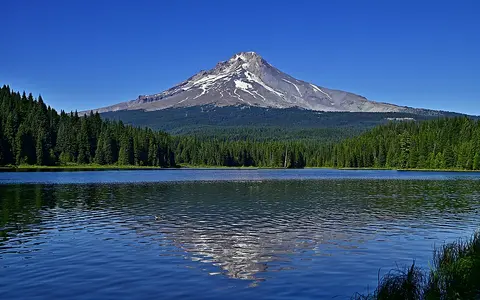
Mount Hood stands in the Cascade Range of northern Oregon, near the boundary between Clackamas and Hood River counties. The mountain rises well above an older volcanic highland, creating a prominent, isolated cone rather than a long ridge. The Columbia River Gorge lies to the north, the lower Willamette Valley and Portland Basin to the west, and the drier Deschutes Plateau to the east.
The present volcano has grown episodically for roughly 500,000 years at a volcanic center active for much longer. It belongs to the Cascadia arc, where subduction of the oceanic Juan de Fuca Plate beneath North America supplies magma to the Cascade chain. In regional context, Hood lies south of Mount St. Helens and southwest of Mount Rainier.
Cone, summit, and flank structure
The edifice consists mainly of andesite and dacite lava flows, breccia, and other fragmental volcanic material. Repeated eruptions accumulated around central and flank vents, while erosion cut deep ravines into the cone. Steep headwalls, ridges, and resistant lava layers give the upper mountain an irregular form despite its broad conical profile.
During much of the past 30,000 years, eruptions have built viscous lava domes high on the mountain. Dome collapse sent pyroclastic flows across the upper flanks and constructed broad aprons of loose debris. Older lava flows extend outward from the core, in some cases reaching about 12 km from their vents, and glacial erosion has exposed their internal layers.
Steep, dissected relief
Rocky ribs divide glaciers and funnel rockfall, meltwater, and debris into radial valleys.
Lava flows and domes
Thick lava built the edifice; younger dome growth and collapse reshaped its upper flanks.
Volcanic aprons
Lava, pyroclastic deposits, glacial sediment, and lahars merge into the surrounding highland.
Glaciers and radial drainage
Glaciers and perennial snowfields mantle the upper cone. Eliot and Coe glaciers occupy the north flank, while Sandy, Reid, Zigzag, White River, Newton Clark, and other ice bodies descend between rocky ridges. Together, present-day glaciers and perennial snow cover occupy about 13.5 square kilometres, a much smaller footprint than the valley glaciers that radiated as far as 15 km from the mountain during the last ice age.
Meltwater and precipitation drain outward in several directions. The Hood River system carries water north to the Columbia River. The Sandy River and its Zigzag tributary drain west and northwest, also reaching the Columbia. The White River runs southeast to the Deschutes River, placing part of Mount Hood within the wider Columbia basin by a different route. These valleys transport abundant sand, gravel, and volcanic debris from the steep cone.
Pacific moisture and the Cascade divide
Moist air arriving from the Pacific rises across the western Cascades, cools, and produces heavy cool-season precipitation at high elevations. Much of it falls as snow on Mount Hood, sustaining seasonal snowpack, perennial snowfields, and glaciers. Elevation keeps the upper cone colder and windier than the surrounding valleys and lengthens the period of snow cover.
The Cascade crest also produces a strong west-to-east moisture gradient. Western drainages face wetter maritime conditions, while descending air east of the crest creates a rain-shadow transition toward the Deschutes Plateau. This contrast affects runoff timing, erosion, vegetation patterns, and the amount of sediment that streams can move from different sides of the mountain.
Lahars, sediment, and downstream valleys
Mount Hood's steep slopes, fractured rock, snow, and ice make its river valleys integral parts of the volcano. Collapsing lava domes can generate hot pyroclastic flows that melt snow and ice; landslides can also transform into water-rich lahars. Past flows moved far beyond the cone through the Sandy, Hood, and White River systems.
A breached area high on the southwest side has directed many younger deposits toward the Zigzag and Sandy valleys. About 1,500 years ago, a debris avalanche and lahar travelled roughly 90 km down this route to the Columbia River. Other deposits record flows north through the Hood River valley and southeast toward the Deschutes. Mount Hood is therefore not only a summit landform: its physical footprint continues along river floors, sediment fans, and deltas well into the surrounding region.