What Piton de la Fournaise is
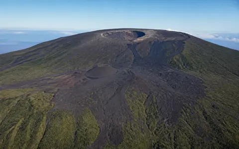
Piton de la Fournaise is the active centre of the younger of Réunion's two adjoining volcanic massifs. It is a shield volcano: its overall form is broad and gently convex because successive eruptions have spread mainly basaltic lava across the flanks. The visible summit, however, is not a simple smooth dome. A central cone rises inside the Enclos Fouqué, a large depression bounded by steep scarps and open toward the east.
The summit area contains the adjoining Dolomieu and Bory craters. Fissures and smaller cones extend down the flanks, and overlapping lava fields record repeated construction of new surfaces. Most eruptions in the historical record have remained within the Enclos and its eastern continuation, so the enclosed summit terrain and the coastal lava apron form the clearest physical unit.
The southeastern Réunion massif
Réunion lies in the Mascarene Islands of the southwestern Indian Ocean, east of Madagascar. Piton de la Fournaise occupies the island's southeastern sector, while the older and more deeply eroded Piton des Neiges massif dominates the northwest. The high Plaine des Cafres area forms part of the broad saddle between them.
The volcanic edifice continues below sea level, so the emerged mountain is only the upper part of a much larger oceanic shield. On land, older scarps and upland surfaces step inward toward the active centre. The Plaine des Sables depression and the Rempart des Sables lie west of the Enclos, while the Rempart de Bellecombe forms a prominent part of the Enclos rim. These nested boundaries preserve stages in the construction and collapse of the southeastern massif.
Central cone, Enclos, and open eastern flank
The Enclos is a horseshoe-shaped depression roughly 8 kilometres across at the summit and open toward the ocean. Its upper, relatively level section is the Enclos Fouqué. Within it, the terminal cone rises to the Dolomieu and Bory craters. Dolomieu is the larger summit depression and has been reshaped by eruptions and floor collapse, while Bory forms the smaller western summit crater.
East of the Enclos Fouqué, the terrain drops through three linked relief zones. The upper enclosure surrounds the cone and young lava fields; below it, the Grandes Pentes descend steeply; farther downslope, the Grand Brûlé spreads as a lower-gradient coastal apron. Northern and southern ramparts border much of this open corridor and separate it from older, more dissected outer slopes.
Dolomieu and Bory
Two adjoining craters crown the active central cone.
Enclos Fouqué
Scarps enclose the summit lava field but leave it open to the east.
Grand Brûlé
Overlapping lava flows form a broad apron beside the Indian Ocean.
Basalt flows across collapse terrain
Fresh lava commonly advances from fissures rather than only from the summit craters. Many vents align along preferred zones extending northeast and southeast from the central cone. Fluid pāhoehoe can form smoother, folded, or ropy surfaces, while broken ʻaʻā develops rough, blocky flow tops and fronts. Channels, levees, lava tubes, scoria cones, and overlapping flow margins add smaller-scale relief across the Enclos.
The broad shield form is therefore interrupted by sharp contrasts: near-vertical ramparts, the steep Grandes Pentes, crater walls, and abrupt lava fronts stand beside smoother constructional slopes. At the Grand Brûlé, flows can reach the coast, cover older surfaces, and extend the shoreline locally. Beyond the frequently resurfaced corridor, older volcanic rocks have had more time to weather and to be cut by ravines.
Trade-wind rain over porous lava
Southeasterly trade winds bring moist oceanic air onto Réunion's windward side. Rising air cools over the massif, making the eastern and southeastern slopes very wet. Tropical cyclones and other intense rain events can add exceptional short-period rainfall. Temperature falls rapidly with altitude, so the exposed summit is much cooler than the coast and can occasionally receive frost or brief snow.
Despite abundant rain, the young central terrain has few permanent surface streams. Water infiltrates joints, lava tubes, and porous zones between basalt flows, feeding perched groundwater bodies and deeper aquifers that drain toward the coast. Surface runoff becomes more important during heavy rain, where flow surfaces are less permeable, or where older weathered layers impede downward movement. Beyond the youngest lava fields, ravines cut the massif's flanks and carry water toward the Indian Ocean.
Hotspot volcanism and island growth
Piton de la Fournaise is an intraplate volcano associated with the Réunion hotspot, not a volcano on a subduction-zone arc. Basalt supplied over a persistent mantle source built Réunion above the ocean floor. As volcanic activity shifted toward the southeast, Piton de la Fournaise grew against the older Piton des Neiges massif, producing the island's paired highland structure.
The contrast between the two massifs shows how time changes volcanic terrain. Young Fournaise surfaces retain craters, vents, fissures, and recognizable lava flows, whereas the older northwestern massif is cut by deep valleys and the great cirques of Réunion. Within Geography Atlas, Piton de la Fournaise connects to the volcanoes hub and the mountains hub. Its east-open lava corridor also provides a useful comparison with the rift zones and coastal flows of Kilauea and Mauna Loa.