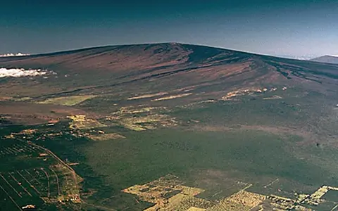

A broad shield-volcano profile
Mauna Loa shows how fluid basaltic lava can build a huge, low-angle volcanic mountain rather than a steep cone.
What Mauna Loa is
Mauna Loa is one of the largest shield volcanoes on Earth by volume and area. Its visible form is broad, not sharply conical.
The record is useful for explaining ocean-island volcano growth and the landforms made by basaltic lava.
The volcano covers just over half of the Island of Hawaiʻi, but its coastline does not mark the edge of the whole volcanic mountain: a much larger submerged area extends beneath the ocean. USGS places its earliest lava flows between about 0.6 and 1 million years ago and estimates that it emerged above sea level about 300,000 years ago. Mauna Loa remains in the shield-building stage, when repeated eruptions rapidly add to a Hawaiian volcano's volume. USGS geology and history.
Long slopes, rift zones, and lava aprons
Mauna Loa's rift zones direct eruptions along linear weaknesses. Lava flows spread from vents and build wide volcanic surfaces.
A shield grows through the accumulation of many lava flows. Fluid basalt spreads away from its eruption site before cooling into rock, leaving layers that dip gently outward. Repetition builds both the height and breadth of the mountain. The broad profile therefore records how lava moves as well as how much material has erupted. A distant view can make the slopes appear modest even though the accumulated volcanic pile is enormous.
This construction differs from a volcano built largely by fragments falling around a vent or by thick, viscous lava accumulating close to its source. Mauna Loa illustrates how successive sheets of mobile lava can distribute new rock over a wide area, producing the characteristic shield outline. USGS explanation of volcano types.
Caldera structure
Collapse and vent activity shape the top.
Basalt flows
Fluid lava travels far across low-angle slopes.
Oceanic growth
The volcano helps build the Hawaiian island mass.
Reading the lava surface
Basaltic lava can leave very different surfaces. Pāhoehoe has smooth, folded or ropy textures, while ʻaʻā has a rough surface of broken, clinkery material. These terms describe the form of the flow rather than two different volcano types. Both help explain why a broadly gentle volcanic slope can have an uneven, difficult surface at ground level.
Lava also travels in different ways: as broad sheets, within open channels, or through tubes beneath a cooled crust. Channel margins can build levees of chilled lava. A crust can insulate the molten interior, allowing it to keep moving after the surface has solidified. Consequently, a dark crust does not by itself describe what is happening inside an active flow.
The distance lava travels depends on more than its composition. The rate of supply and the slope beneath it also matter; higher discharge generally allows flows to move faster and farther. These processes connect the small-scale textures of basalt to the broad lava aprons that build a shield. National Park Service guide to basaltic lava flows.
The summit and rift zones
Mokuʻāweoweo, the summit caldera, is a depression formed by collapse. Its enclosing rim can retain lava erupted inside it, so a summit eruption need not immediately send flows down the outer slopes. The Northeast and Southwest Rift Zones provide other eruption locations extending away from the summit. They are not the only possibilities: geologists have also mapped radial vents on the north and west sectors. The distinction between a summit vent, a rift vent and a flow farther downslope is essential when reading an eruption map. USGS account of summit and vent geography.
The 2022 eruption as a geographic example
The eruption that began on November 27, 2022 demonstrates how eruption location and lava distribution can change within a single event. Lava first spread across much of the summit caldera floor. On November 28, summit effusion stopped and activity shifted into the Northeast Rift Zone. Several fissures initially erupted there, before the supply became concentrated at fissure 3 by November 30.
Flows fed from that vent extended about 18 kilometres northward, threatening but not reaching the Daniel K. Inouye Highway. Lava effusion ceased on December 10, after new flows had covered approximately 36 square kilometres. The sequence connects three distinct features: the summit depression where the eruption began, the rift fissures that supplied later lava, and the downslope terrain across which the flows advanced. USGS documented these changes with mapped flow outlines, aerial imagery and thermal mapping. USGS geospatial account of the 2022 eruption.