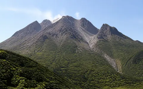
What Mount Unzen is
Mount Unzen, also known collectively as Unzendake, occupies central Shimabara Peninsula in Nagasaki Prefecture. The name refers to a mountain group rather than a single, regular summit cone. Its footprint extends about 20 km east to west and 25 km north to south, with high ground rising between Tachibana Bay on the west and the Ariake Sea on the east.
The volcanic complex includes older, deeply eroded massifs and younger lava-dome centers. Its present high point is Heisei-Shinzan, the 1,483 m dome built during the 1990–96 eruptive episode beside Fugen-dake, whose older summit reaches 1,359 m. The young dome, adjacent peaks, collapse scars, and faulted slopes create an irregular skyline and strong local relief above the peninsula's coastal lowlands.
Overlapping centers within a faulted mountain belt
Unzen's central mountain mass lies within the roughly 9 km-wide Unzen graben. Numerous east–west faults mark this subsiding and extending belt, displacing older volcanic surfaces and helping separate blocks of highland from adjacent low ground. The west preserves much of the older complex, including strongly dissected terrain around Kusenbu-dake and other remnants built mainly between about 500,000 and 100,000 years ago.
Younger volcanism migrated into the east-central part of the peninsula. Nodake, Myōken-dake, Fugen-dake, and Mayuyama are not stages of one simple cone; they are distinct but overlapping centers dominated by domes and thick lava. An east-facing collapse depression in the Myōken area contains much of the younger Fugen-dake complex, while Mayuyama forms a separate pair of large domes closer to Shimabara's eastern coastal plain.
Dissected western massifs
Fault movement, weathering, and stream erosion have softened and divided the earliest volcanic forms.
Fugen-dake and Heisei-Shinzan
Young domes and thick lava form the highest, steepest part of the present complex.
Mayuyama
Two large dacite domes rise between the central peaks and Shimabara's coastal edge.
Viscous lava builds domes and steep flow fronts
Unzen is built chiefly from andesite and dacite. These relatively silica-rich, viscous magmas tend to accumulate near vents as lava domes or advance as short, thick flows rather than spread into the broad, low-angle sheets typical of fluid basalt. Resistant lava creates ridges, knobs, and abrupt fronts; fragmented lava, ash, and pyroclastic-flow deposits form looser aprons around them.
The 1990–96 episode made this contrast especially clear. Lava extruded near Fugen-dake to build the blocky Heisei-Shinzan dome. Repeated failure of unstable dome margins sent pyroclastic material into valleys on the eastern side, laying down lobate deposits and talus below the summit. Older parts of Unzen preserve the same long-term pattern on a larger scale: dome growth alternated with collapse, erosion, and the spreading of debris across lower slopes.
Collapse scars and aprons interrupt the volcanic flanks
Gravity has been as important as eruption in shaping the complex. Steep lava masses can fail along fractured rock, altered zones, or faulted slopes. Large collapses leave open scars and transfer blocks, ash, and broken rock to gentler ground, where hummocky debris-avalanche terrain and broad sediment aprons partly bury the original cone surfaces.
Mayuyama's 1792 collapse is the clearest historic example. A large part of its eastern flank moved toward the sea, cutting a major scar into the dome complex and spreading debris across the coastal margin and into Shimabara Bay. The resulting irregular deposits became part of the peninsula's modern lowland and nearshore geography. Around Fugen-dake, smaller collapses and pyroclastic deposits have repeatedly reworked the heads of valleys without producing a smooth radial cone.
Short rivers connect summit valleys to two coasts
The central divide sends water west toward Tachibana Bay and east toward the Ariake Sea. Because the mountain group occupies a narrow peninsula, most catchments are compact and their rivers descend rapidly from upland valleys to coastal plains. Drainage is locally diverted by dome margins, collapse deposits, fault scarps, and fan surfaces rather than following a perfectly radial pattern.
On the eastern flank, the Mizunashi and Nakao river systems drain terrain below Fugen-dake and Heisei-Shinzan. Coarse, fractured lava can absorb rainfall, but ash-rich layers and saturated pyroclastic deposits produce rapid runoff. Heavy rain remobilizes loose volcanic material into sediment-rich floods and debris flows, which deepen channels, build fans, and carry summit-derived material toward the coastal lowland.
Maritime monsoon rainfall drives erosion
The Shimabara Peninsula has a humid, maritime climate shaped by surrounding seas and the East Asian monsoon. The early-summer rainy season and tropical cyclones can deliver intense rainfall, while moist air rising over Unzen's central high ground increases cloud and precipitation on exposed slopes. Upper ridges are cooler and windier than the coastal plain, with occasional winter snow but no permanent ice.
Rainfall is the main climatic control on present landform change. It cuts gullies into ash and weathered lava, moves sediment through short mountain channels, and enlarges fans where slopes flatten. Vegetation and developed soils stabilize older surfaces, while fresh or sparsely consolidated deposits near young domes and valley floors remain more easily eroded.
A peninsula volcano at an extending plate margin
Unzen stands near the western end of the Beppu–Shimabara zone, a belt of extensional basins and faults that crosses central Kyushu. The local Unzen graben is one expression of that extension. At the broader scale, volcanism in Kyushu is related to subduction of the Philippine Sea Plate beneath the continental margin, but Unzen's exact form reflects the interaction of magma supply with crustal stretching, fault movement, and repeated edifice collapse.
The mountain complex also forms the physical core of Shimabara Peninsula. It separates short western catchments from the wider eastern apron, links the peninsula's coastal plains through passes around the central peaks, and stands across the Ariake Sea from western Kyushu. Within the atlas, Unzen can be compared with Sakurajima, another southern Japanese volcano shaped by a subsiding basin, and with Mount Fuji, whose more unified cone contrasts with Unzen's faulted, multi-center relief.