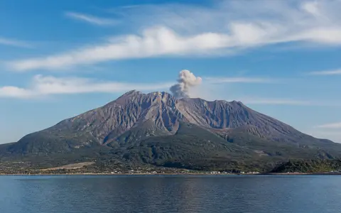
What Sakurajima is
Sakurajima occupies the central part of Kagoshima Bay in Kagoshima Prefecture. Although its name means “cherry blossom island,” it has been joined to the Ōsumi Peninsula since lava from the 1914 eruption filled the narrow Seto Strait on its eastern side. Water still separates most of the volcanic landform from the surrounding shores of Kyushu.
The summit complex rises steeply above a narrow coastal apron. Its position is especially important: Sakurajima is not the main caldera itself, but a younger composite volcano built along the southern edge of Aira caldera, which underlies the northern part of the bay.
Overlapping northern and southern cones
The volcano is formed chiefly by two overlapping stratovolcanoes. Kitadake, the older northern cone, reaches the highest point at Ontake. Minamidake is the younger southern cone and contains the summit crater that has been the main focus of recorded summit activity. Nakadake stands between them as a smaller vent-built peak, producing a north–south line of high ground.
Several flank vents and subsidiary landforms, including Gongenyama, Nabeyama, and Hikinohira, interrupt the otherwise radial slopes. Lava scarps, crater rims, gullies, and overlapping flow surfaces make the relief more complex than a single smooth cone.
Kitadake
The older and higher part of the composite edifice carries the 1,117 m summit.
Nakadake
A smaller vent-built peak lies between the two principal cones.
Minamidake
The younger cone contains the principal summit crater and steep upper flanks.
Lava flows remade the edge of Kagoshima Bay
Sakurajima measures roughly 12.2 km from east to west and 9.5 km from north to south. Its broad base meets Kagoshima Bay through low lava fields, sediment aprons, short alluvial surfaces, and small embayments rather than through one regular circular coast.
Successive flank eruptions sent lava toward the water and created projecting lobes along several sides of the former island. The 1914 eastern flow made the largest geographic change in recorded time by closing the Seto Strait. This produced the present peninsula connection while leaving the western shore facing Kagoshima across a narrow arm of the bay.
Lava, tephra, and young volcanic surfaces
The main cones consist of interlayered lava and pyroclastic material. Their rocks range mainly from andesite to dacite. More resistant lava forms flow fronts, ridges, and local scarps, while ash, lapilli, blocks, and other fragmental deposits mantle many slopes and collect in gullies.
Eruptions have opened vents at the summit, on the flanks, and beneath nearby water. As a result, Sakurajima is a patchwork of surfaces with different ages and textures: older dissected cone slopes lie beside younger lava fields and loose ash-covered terrain. This contrast controls how quickly rainwater infiltrates, runs off, and moves sediment downslope.
Short radial catchments and sediment-laden flows
Because the cone rises close to the coast, its drainage basins are small and steep. Rainwater moves outward from the summit area through radial gullies and channels, then reaches the bay after only a short course. Fractured lava and coarse deposits can absorb water locally, while compact or saturated ash layers promote rapid surface runoff.
Fresh ash and loose volcanic fragments provide abundant sediment. Intense or sustained rain can remobilize this material into debris flows, or rain-generated lahars, that follow the established valleys toward the coastal apron. Drainage on Sakurajima therefore links summit deposits directly to fan building, channel change, and sediment delivery at the shoreline.
Humid coastal weather over a steep cone
Southern Kyushu has a humid subtropical climate influenced by the surrounding sea, the East Asian monsoon, the early-summer rainy season, and occasional tropical cyclones. Warm, moisture-rich air supplies heavy seasonal rainfall to both the low coastal belt and the higher cone.
Elevation makes the upper slopes cooler and more exposed than the shore, but the summit is too low to support permanent snow or ice. Rainfall is the main climatic force reshaping the volcano: it cuts gullies into ash-covered slopes and repeatedly transfers loose material into lower channels and fans. Seasonal winds also determine which slopes and neighboring shores receive the greatest ash fall during an eruption.
A volcanic cone within the Kagoshima graben
Aira caldera forms a broad depression in the northern half of Kagoshima Bay, within the north–south-trending Kagoshima graben. Sakurajima stands on its southern margin, linking the caldera basin to the narrower central bay and the volcanic uplands of the Ōsumi Peninsula. Across the water to the west, the steep cone is separated from central Kagoshima by only a small part of the bay.
At plate scale, Sakurajima belongs to the Ryukyu volcanic arc, associated with subduction of the Philippine Sea Plate beneath the margin of Eurasia. Within the atlas, its position can be compared with Taal Volcano, where younger vents occupy a lake-filled caldera, and with Mount Fuji, whose more isolated cone rises in a different Japanese plate-margin setting.