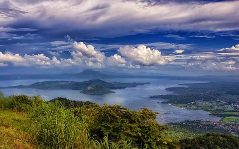

What Taal Volcano is
Taal lies in Batangas Province, about 65 km south of central Manila. The name refers to more than the active vents on Volcano Island: the full volcanic system includes the surrounding caldera, Taal Lake, submerged eruptive centers, and the younger island complex near the lake's north-central area.
Its highest mapped point is only about 311 m above sea level, so Taal does not have the tall, isolated profile associated with many stratovolcanoes. Its defining relief is instead the nested arrangement of basin, lake, island, and crater.
Caldera rim, lake basin, and inner island
The outer landform is a caldera roughly 15 by 20 km across. Its margins appear as uplands around Taal Lake, while the collapse basin is largely submerged. The lake covers about 267 km², lies only a few metres above sea level, and reaches a maximum depth of about 160 m.
Volcano Island was built after the large caldera-forming eruptions. Rather than being one simple cone, it is a compound surface made from closely spaced small stratovolcanoes, tuff rings, scoria cones, craters, and eruption deposits. Main Crater cuts into the island and has held a crater lake, creating a smaller water-filled depression within an island already enclosed by the much larger caldera lake.
Taal Caldera
A broad collapse depression defines the scale of the entire volcanic system.
Taal Lake
Fresh water fills most of the caldera and separates Volcano Island from the mainland rim.
Volcano Island
Multiple vents and overlapping small landforms record repeated post-caldera eruptions.
A caldera lake connected to the sea
Taal Lake gathers direct rainfall, runoff from the caldera slopes, and drainage from the mainland catchment around its rim. Its sole surface outlet is the Pansipit River, which flows southwest to Balayan Bay. This narrow outlet links the inland volcanic basin to the coastal drainage network.
Water is also integral to the volcano's smaller landforms. Main Crater and several submerged vents place magma, hot rock, groundwater, and surface water close together. Explosive water-magma interaction has therefore been an important process in shaping craters, tuff rings, and fine-grained eruption deposits.
Tropical rainfall over low volcanic relief
Southern Luzon's warm tropical climate supplies rainfall to the lake and its catchment, with seasonal monsoon circulation and tropical cyclones producing pronounced wet periods. Because the caldera floor is occupied by a large lake, rainfall and evaporation influence basin water levels directly.
Rain also washes loose ash from exposed slopes into craters, shorelines, and lake water. Taal's modest elevation means temperature contrasts with the surrounding lowlands are less dramatic than on high cones such as Mount Pinatubo; the dominant climate control is the seasonal movement and concentration of moisture rather than a long altitudinal belt.
Southwestern Luzon and the Manila Trench
Taal belongs to the Luzon volcanic arc and lies within the Macolod Corridor, a zone of volcanic and tectonic structures across southwestern Luzon. Its magma is related to eastward subduction along the Manila Trench west of the island.
The caldera occupies an inland position close to the coast, connecting the volcanic uplands of Batangas with Balayan Bay through the Pansipit drainage. Within the atlas, Taal complements Pinatubo's highland caldera and lahar valleys, while its nested lake-and-island form can also be compared with the marine-flooded basin of Santorini Caldera.