What Mount Rinjani is
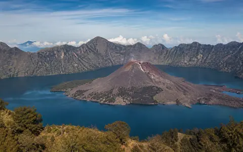
Mount Rinjani rises across northern Lombok in Indonesia's Lesser Sunda Islands. From the east it appears as a steep cone, but the mountain is not a simple symmetrical peak. Its western side opens into the much larger Segara Anak caldera, while the surviving 3,726-metre summit forms the highest part of the eastern rim and outer edifice.
In physical geography terms, Rinjani is a compound volcanic massif shaped by construction, collapse, renewed volcanism, and erosion. Lava and fragmental deposits built the older mountain; the 1257 eruption of Samalas removed much of that edifice and formed the caldera; later eruptions built new cones and lava surfaces inside the depression.
High rim, collapse basin, and younger cones
The main caldera is an oval basin roughly 6 by 8.5 kilometres across and enclosed by steep walls. Relief within the complex is pronounced: the lake surface lies close to 2,000 metres above sea level, while Rinjani's eastern summit rises more than 1,700 metres higher. A separate crater about one kilometre wide cuts the high eastern summit area.
Post-caldera volcanism is concentrated on the caldera floor. Barujari, a cone near the eastern end of Segara Anak, has built lava flows and a broad peninsula into the lake. Smaller vents and domes add further relief, so the basin contains active constructional landforms inside the larger collapse structure.
Surviving high summit
The 3,726-metre peak forms the steep eastern side of the complex rather than the center of a complete cone.
Large collapse basin
Steep inner walls surround a floor occupied by a lake, young cones, lava fields, and sediment aprons.
Barujari
Repeated eruptions have built a post-caldera cone whose lava flows extend into Segara Anak.
Segara Anak and outward drainage
Segara Anak occupies the western part of the caldera as a crescent-shaped lake covering about 11 square kilometres. It is more than 200 metres deep in places and receives rainwater, slope runoff, groundwater, and hydrothermal inputs. Hot springs and gas discharge around the caldera show that the lake is part of an active volcanic-hydrologic system.
Water leaves the caldera through a low northern outlet into the Kokok Putih catchment. Changes in lake level can therefore affect discharge beyond the rim. On the outer massif, streams follow shorter radial valleys away from the summit and caldera walls, cutting volcanic deposits and carrying water and sediment toward Lombok's lower slopes and coastal plains.
Monsoon seasonality and mountain rainfall
Rinjani stands within a tropical monsoon region with a generally wetter season from about November to April and a drier season from about May to October. The mountain strongly modifies this island-scale pattern. Moist air rises across the high flanks, encouraging cloud and rain, while some eastern and leeward valleys receive less precipitation than exposed windward slopes.
Elevation lowers temperatures from the foothills to the summit and increases the frequency of cloud, strong wind, and rapid weather changes on exposed ridges. Seasonal rain is also a major geomorphic control: it feeds the caldera lake, cuts gullies, remobilizes ash and loose pyroclastic debris, and concentrates sediment movement in steep channels.
Lombok relief and the Sunda Arc
Rinjani anchors northern Lombok's volcanic highlands. Its long outer slopes descend toward foothills and coastal lowlands, while older volcanic terrain around Sembalun extends the rugged upland setting east of the main summit. The massif acts as both a topographic divide and a source area for catchments across much of the island's north.
At the plate scale, Rinjani belongs to the Sunda Volcanic Arc, formed above subduction south of the Lesser Sunda Islands. It lies between Mount Agung on Bali to the west and Mount Tambora on Sumbawa to the east. Agung provides a contrast in steep cone form, while Tambora provides another example of a large caldera embedded in an island-arc volcano.