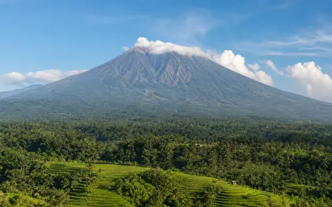
What Mount Agung is
Mount Agung rises above the eastern part of Bali in the Lesser Sunda Islands. Its northern and southern flanks descend toward narrow coastal belts, while its western side meets the higher volcanic country around the Batur caldera. This position gives the cone a strong island-scale presence in the relief of eastern Bali.
In physical geography terms, Agung is a composite volcanic edifice built by repeated lava flows and explosive deposits. The landform includes more than its summit: a steep upper cone, broad lower slopes, radial ridges and ravines, a low subsidiary cone on the southeast flank, and volcanic sediment pathways that continue toward the coast.
Summit ridge, crater, and outward flanks
Agung's summit is not a single sharp point. The uppermost ground extends for about 1.5 kilometres from east to west, with the highest point on the western side and a broad, steep-walled crater occupying the eastern summit area. The crater and its exposed layers record alternating lava emplacement and fragmental eruptions.
Below the summit, the cone widens rapidly. Lava-built ridges and aprons of ash, scoria, blocks, and pyroclastic-flow material form the flanks, while erosion has cut narrow valleys between them. The small Pawon cone on the lower southeast side adds a secondary volcanic form to the otherwise dominant central edifice.
Elongated high ridge
The highest western rim and eastern crater give the summit an uneven east–west profile.
Open steep-walled basin
The principal summit crater is about 800 metres wide.
Radial ridges and aprons
Lava and fragmental deposits spread outward and are divided by steep erosion channels.
Short catchments and lahar pathways
Agung's drainage is strongly radial. Rain falling high on the cone enters short, steep gullies that deepen downslope and carry water toward Bali's northern, eastern, and southern coasts. The Sakta River valley on the eastern flank is one example of a channel cut into the volcanic edifice.
Loose ash and pyroclastic debris make these valleys important sediment routes. During intense rain, water can remobilize fresh or older deposits as debris-rich floods and lahars. The effect can continue after an eruption has ended because steep gradients, abundant loose material, and seasonal downpours remain connected through the same ravine network.
Monsoon seasonality and elevation
Eastern Bali has a tropical monsoon climate with a generally wetter period from about November to April and a drier period from about May to October. Agung's elevation modifies that regional pattern: temperatures fall upslope, clouds form frequently around the upper cone, and exposed summit terrain experiences stronger winds and rapid changes in visibility.
Rainfall is also a geomorphic control. Wet-season storms cut gullies, move ash and gravel, and feed short-lived high flows in channels that may be dry or modest at other times. During drier intervals, bare fine material can remain exposed to wind before later rain carries it farther downslope.
Bali's volcanic backbone and the Sunda Arc
Agung stands immediately southeast of the Batur caldera complex and rises above its southeastern rim. Together, the high cone, older caldera walls, volcanic uplands, and adjoining lowlands form a connected section of Bali's east–west mountain axis rather than a set of isolated peaks.
At the plate scale, Agung belongs to the Sunda Volcanic Arc, generated above the subduction zone south of Indonesia. It can be compared with Mount Bromo, a small active cone inside an East Java caldera, and Mount Merapi, a dome-building Java stratovolcano with steep lahar valleys. Mount Tambora provides a farther-east example of a much larger summit-collapse landform on Sumbawa.