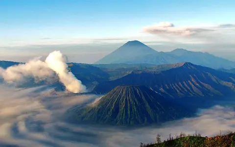

What Mount Bromo is
Mount Bromo is a low, steep-sided volcanic cone within the Tengger caldera complex of eastern Java. It is one of several cones on the floor of the younger Sandsea caldera, but it is the only one that has produced recorded historical eruptions. The broader complex includes overlapping older stratovolcanoes and calderas rather than a single isolated mountain.
This nested setting is the key to reading Bromo's geography. The active crater belongs to a relatively small cone; the level ash plain around it is a caldera floor; and the high ridges on the horizon are remnants of older volcanic edifices and collapse walls.
Crater, cone, and the Sandsea floor
Bromo is built mainly from loose scoria, ash, and other fragmental ejecta around a summit crater. Repeated small explosive eruptions have maintained the open vent and spread fine material across the cone and adjoining basin floor. The crater is roughly oval, about 600 by 700 metres, and its internal form records shifts in the position of the eruptive vent.
The cone stands among several post-caldera landforms, including the deeply furrowed Batok cone immediately to the west. Together these cones interrupt the otherwise broad floor of the Sandsea caldera. Beyond them, the caldera wall rises as a distinct rim, creating an enclosed highland basin with strong contrasts between flat floor, short steep cones, and older outer ridges.
Open active crater
A broad crater and persistent venting mark the youngest eruptive centre in the complex.
Fragmental slopes
Scoria and ash form steep, readily eroded flanks above the caldera floor.
Sandsea caldera
A wide ash- and sediment-covered floor surrounds Bromo and its neighbouring cones.
Runoff in an ash-filled basin
No large permanent river begins at Bromo's summit. Water movement is instead organized by short cone slopes, the enclosed caldera floor, and breaches or valleys in the wider complex. Rain falling on loose ash can infiltrate, collect in shallow channels, or carry sediment downslope during intense storms.
The fine-grained Sandsea surface can alternate between dry, wind-reworked ground and wet, locally channelled terrain. On the cone itself, runoff cuts gullies into unconsolidated deposits; across the basin, slope wash redistributes ash around the bases of Bromo, Batok, and the other post-caldera cones.
Monsoon rainfall, elevation, and exposure
Bromo lies in Java's tropical monsoon zone, but elevation makes the caldera cooler than the surrounding lowlands. Seasonal shifts in rainfall govern much of the surface response: wetter months increase erosion and ash transport, while drier intervals allow exposed sediment to be lifted and redistributed by wind.
The surrounding rim and neighbouring cones also create local differences in cloud, wind, and rainfall exposure. These controls help explain why the caldera floor is not a uniform surface and why fresh ash can be reworked after it has settled, even without a new eruption.
The Tengger–Semeru massif and Sunda Arc
The Tengger complex occupies the northern end of a volcanic massif that extends south to Semeru, Java's highest volcano. Bromo is therefore part of a connected high-relief region in which older caldera walls, younger cones, saddles, and outward-draining valleys divide the interior basin from the surrounding East Java lowlands.
At the plate scale, the complex belongs to the Sunda Volcanic Arc, formed above subduction south of Java. Bromo complements Mount Merapi, a steep dome-building cone in central Java, and Mount Tambora, a much larger caldera-bearing edifice on Sumbawa. Together, the records show how different volcanic forms occur along the same regional arc.