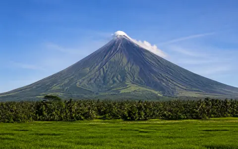
What Mount Mayon is
Mount Mayon occupies the eastern side of the Bicol Peninsula in Albay, northwest of Legazpi City and close to the shore of Albay Gulf. It rises from densely dissected foothills and low volcanic plains rather than from a long mountain ridge, so the cone forms a distinct center of relief within the surrounding landscape.
Mayon is a composite, or stratovolcano, built mainly by lava flows, lava-fountain deposits, ash, and other pyroclastic material erupted from a persistent central summit area. Its geographic form is therefore best understood as a complete edifice: a crater and steep upper cone, deeply channelled middle flanks, and lower fans where slope angle and flow energy decrease.
Summit crater, steep cone, and lower apron
A small crater caps Mayon's summit. Below it, the upper flanks commonly reach gradients of roughly 35 to 40 degrees. Coherent lava and welded fragments deposited close to the vent help support these steep slopes, while successive flows and fragmental layers thicken the cone outward from the central conduit.
The gradient eases toward the base, where lava-flow surfaces, pyroclastic deposits, reworked sediment, and overlapping alluvial fans spread across a footprint about 20 km wide. The cone appears regular at regional scale, but close inspection reveals irregular lava lobes, ridges, scarps, and ravines produced by repeated deposition and erosion.
Central crater
A compact summit vent focuses much of the material that builds the upper cone.
Layered steep slopes
Lava, welded ejecta, ash, and pyroclastic deposits form the cone's high-relief core.
Volcanic and alluvial apron
Lower gradients allow rock debris and water-borne sediment to spread beyond confined gullies.
Radial ravines from summit to lowland
Mayon has no permanent summit snowfield or crater lake. Water enters the system mainly as rain, then runs outward through a dense radial network of ravines. Major gullies such as Mi-isi, Bonga, and Basud drain the southern and eastern flanks, while other channels divide the remaining sides of the cone into narrow interfluves.
On the upper slopes, channels are steep and confined. Farther downslope they widen, lose gradient, and merge with fans, floodplains, and short river systems around the volcano. Heavy rain can remobilize ash, loose blocks, and older pyroclastic material as sediment-rich floods or lahars, carrying volcanic material well beyond the high cone. Some drainage reaches Albay Gulf directly; other channels cross the surrounding lowlands before entering the regional coastal network.
Tropical moisture over an isolated high cone
Mayon's position on the Bicol Peninsula exposes it to warm, moisture-bearing air from nearby seas. Rain falls through much of the year, with monsoon circulation and tropical cyclones capable of producing intense episodes. The volcano's height forces air upslope, encouraging cloud and rainfall and creating cooler, wetter conditions toward the upper cone.
Climate acts directly on the landform. Repeated rainfall cuts into loose surface deposits, deepens ravines, and transfers sediment to the lower apron. During exceptional storms, rapid runoff can combine with newly deposited or older volcanic debris, so the same radial channels that drain ordinary rain also organize larger sediment flows.
Bicol Arc above the Philippine Trench
Mayon belongs to the Bicol volcanic arc, part of a chain of volcanic centers along southeastern Luzon and the eastern Philippines. The arc is related to oblique westward subduction of the Philippine Sea Plate at the Philippine Trench east of the archipelago. Melt generated above the descending plate supplies the magma systems that have built Mayon and neighboring volcanic terrain.
At the surface, the cone links the Bicol uplands with Albay's coastal plains and Albay Gulf. Within the atlas, Mayon complements the lake-and-caldera geography of Taal Volcano and the collapse-and-lahar terrain of Mount Pinatubo. Its high central cone also provides a useful Philippine comparison with the more subdued radial drainage and seasonal snow cover of Mount Fuji.