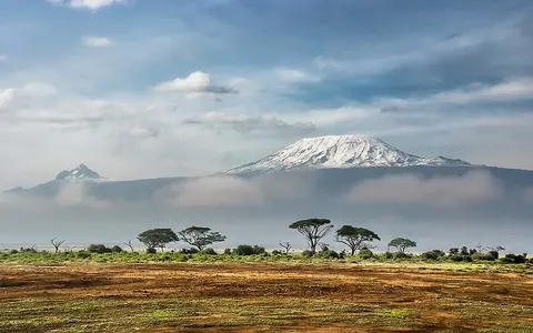

What Mount Kilimanjaro is
Mount Kilimanjaro stands near Tanzania's border with Kenya, about three degrees south of the equator. It is not one simple cone but an elongated volcanic complex aligned broadly northwest to southeast. Its immense local relief makes it the dominant landform between the dry plains of the Amboseli basin to the north and the Pangani drainage region to the south.
Kibo forms the high central and western mass, Mawenzi rises as a jagged, deeply eroded peak to the east, and the older Shira center survives mainly as a broad ridge and caldera remnant to the west. Saddles of high volcanic terrain connect the three centers into one mountain mass.
Kibo, Mawenzi, and Shira
Kibo is the youngest and largest of the three main edifices. Its upper slopes lead to a broad summit platform cut by a caldera roughly 2.4 by 3.6 kilometres across. Nested craters and the Reusch pit occupy the summit area, while the Western Breach interrupts the southwestern caldera rim. Uhuru Peak, the massif's highest point, lies on the rim rather than at the center of a pointed cone.
Mawenzi has been cut into narrow ridges, gullies, and rock pinnacles by long erosion, exposing a much rougher profile than Kibo. Shira is older still; collapse and erosion removed much of its former cone, leaving a western plateau and arc of high ground. Lava flows and many smaller parasitic cones spread across the lower flanks of the combined massif.
Kibo
A broad, high cone with a summit caldera, nested craters, and remnant ice fields.
Mawenzi
A sharply dissected older edifice whose ridges and ravines reveal prolonged erosion.
Shira
An eroded and partly collapsed volcanic center preserved as a ridge and plateau.
Radial slopes and disappearing streams
Drainage begins in shallow ravines and gullies that fan outward from the upper massif. The wetter southern and southeastern slopes support the most developed stream networks, feeding tributaries within the Pangani River basin. On the northern side, runoff descends toward the drier interior basin around Amboseli.
Porous lava, ash, and weathered volcanic deposits allow much precipitation to infiltrate before it forms permanent surface channels. Water can move through the volcanic pile and reappear as springs around the lower slopes. Consequently, the drainage pattern is broadly radial but uneven: perennial flow is concentrated where rainfall, slope material, and groundwater pathways permit it.
Equatorial air shaped by height
Kilimanjaro's height forces moist air upward, cooling it and increasing rainfall on favored middle slopes. The southern and eastern flanks generally receive more moisture than the northern rain-shadow side. Rainfall is seasonal, reflecting the movement of tropical convergence and shifts in Indian Ocean airflow rather than a four-season temperate cycle.
Temperature falls steeply with elevation. Warm lower plains give way to a cool, humid montane belt, then to colder and drier upper slopes where vegetation becomes sparse. Above about 5,000 metres, freezing conditions and low humidity shape an alpine summit environment. Small glaciers and ice fields remain on Kibo, but they now occupy only separated parts of the summit plateau and upper rim.
Volcanism beside the East African Rift
Kilimanjaro lies near the eastern branch of the East African Rift, where extension has fractured and thinned continental lithosphere. Magma rising through this rift-related setting built the massif mainly during the Pleistocene. Its alkaline volcanic rocks and continental position distinguish it from subduction-zone cones such as Mount Fuji and Cotopaxi.
The mountain is part of a broader field of northern Tanzanian volcanic relief that includes Mount Meru to the southwest. In the volcanoes hub, it provides a useful comparison with Mount Elbrus: both are high volcanic massifs with more than one summit center, but Kilimanjaro rises from tropical rift terrain rather than a temperate mountain chain.