.jpg)
What Mount Elbrus is
Mount Elbrus is a large volcanic massif in southern Russia, near the boundary between Kabardino-Balkaria and Karachay-Cherkessia. It stands north of the Greater Caucasus watershed and is built from lava flows, domes, and fragmental volcanic deposits accumulated during repeated eruptive phases.
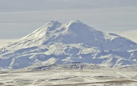
The mountain is not a single sharply pointed cone. Its upper profile is dominated by two rounded summits, while long volcanic slopes spread outward above older ridges and river valleys. An extensive ice cap and numerous outlet glaciers conceal much of the summit structure and continually rework the exposed volcanic terrain.
Western Greater Caucasus setting
Elbrus rises in the western part of the Greater Caucasus, north of the range's main crest and roughly between the upper Kuban basin to the west and the upper Baksan basin to the east. Its position places it within the Caucasus mountain system but off the central line of the highest folded and faulted ridges.
The massif towers above surrounding uplands because volcanic material was added onto an already elevated regional foundation. Deep valleys isolate its flanks, while passes and ridges connect it to the broader Caucasus relief. This combination of a broad volcanic base and strongly incised margins gives Elbrus both great elevation and pronounced local relief.
Summit domes and lava-built flanks
The western and eastern summits represent the upper parts of adjoining volcanic edifices. The western dome reaches 5,642 metres, while the eastern dome reaches 5,621 metres; a saddle at about 5,300 metres lies between them. Crater remnants are subdued by erosion and permanent snow and ice rather than expressed as one large open summit crater.
Below the summit zone, thick lava sequences and volcanic debris create a wide, irregular apron. Erosion has cut into older flows, and later lava followed parts of the pre-existing relief. The resulting massif is asymmetrical at valley scale even though its distant outline appears broadly domed.
Highest dome
The younger-looking western edifice forms the massif's maximum elevation.
Cratered dome
The eastern summit preserves a more recognizable crater-like depression beneath ice and snow.
Lava and incised valleys
Broad volcanic slopes descend into glacially and fluvially cut drainage basins.
Glaciers feeding radial headwaters
A continuous cover of snow and ice mantles much of upper Elbrus. Outlet glaciers radiate from this accumulation zone into valleys on every side, carving and widening channels while transporting rock debris downslope. Moraines, outwash, and unstable debris-covered ice mark the transition from the summit ice cap to lower valley terrain.
Meltwater enters several major drainage systems. Western and northern slopes contribute to tributaries of the Kuban River, which reaches the Black Sea, while eastern and southeastern slopes feed the Malka and Baksan systems within the Terek basin, whose waters flow toward the Caspian Sea. Elbrus therefore lies close to a major regional divide between two large receiving basins.
Altitude, westerly moisture, and exposure
Elbrus has a strongly elevation-controlled mountain climate. Air cools upslope, precipitation increasingly falls as snow, and high winds redistribute snow across the summit plateau and lee slopes. The upper massif remains cold throughout the year, while lower valleys experience a larger seasonal range and a longer melt season.
Moisture arriving from the west and southwest is lifted across the Caucasus, producing substantial precipitation at high elevations. Local slope orientation alters snow accumulation and solar exposure, so glacier size and melt rates vary around the massif. Seasonal meltwater peaks link atmospheric conditions on the summit directly to river flow and sediment movement below.
Volcanism within a collision mountain belt
The Greater Caucasus developed along a broad zone of convergence between the Arabian and Eurasian plates. Elbrus's volcanism occurred within this regional setting of crustal deformation, uplift, and faulting, but the volcano is a younger construction than much of the folded mountain terrain around it. Its most recent eruptions occurred in the late Holocene, and present-day signs of residual heat include warm and mineralized springs around the massif.
Within Geography Atlas, Mount Elbrus is best read with the volcanoes hub for its lava-built structure and the mountains hub for its relief, glaciers, and position in the Greater Caucasus.