.jpg)
What Mount Ararat is
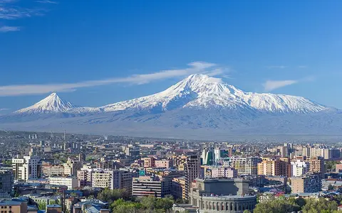
Mount Ararat, also called Ağrı Dağı, is a large volcanic complex in the easternmost part of Turkey. Greater Ararat is the dominant ice-capped cone, while Lesser Ararat rises roughly 11 kilometres to the southeast across a high saddle. Together they stand far above the surrounding plateau and basin surfaces.
The massif is more complex than a single regular cone. Its terrain includes stratovolcano edifices, lava domes, pyroclastic cones, fissure-fed lava flows, glacial landforms, and ravines cut into volcanic deposits. These overlapping features record repeated construction followed by erosion and slope failure.
Eastern Anatolian highland setting
Ararat rises in Turkey's Ağrı and Iğdır region near the borders with Armenia and Iran. It occupies the eastern Anatolian interior, within the broader Armenian Highlands, where elevated plateaus and fault-bounded lowlands surround isolated volcanic massifs.
The mountain's position creates exceptional local relief. Broad lower slopes descend toward the Aras valley and Iğdır Plain to the north and northeast, while uplands continue west and south toward other volcanic terrain. The massif therefore forms both a prominent topographic barrier and a source area for sediment moving onto adjacent plains.
Cones, fissures, and lava aprons
Greater Ararat is the larger edifice, built mainly from lava and fragmental volcanic material. Lesser Ararat is a separate, more sharply conical peak on the southeastern side of the complex. Later flank eruptions opened vents and fissures around both volcanoes, adding cinder cones, lava domes, and extensive lava-flow surfaces.
Many vents follow roughly north-south fissures. Dark lava fields spread across parts of the southern flanks, while older flows and explosive deposits form uneven aprons around the main cones. This distribution gives the massif a broad base and varied surface texture rather than a uniformly smooth radial profile.
High main cone
The summit edifice carries permanent ice and the massif's greatest relief.
Southeastern cone
A distinct subsidiary volcano rises beyond the inter-cone saddle.
Vents and lava fields
Cones, domes, fissures, and flows widen the volcanic complex.
Summit ice, ravines, and radial drainage
An ice cap covers the highest part of Greater Ararat, and outlet glaciers and debris-covered ice descend from the summit zone. Glacial erosion, freeze-thaw action, and rockfall reshape the upper slopes, producing a terrain in which volcanic and cold-climate landforms overlap.
Water drains outward through steep gullies and seasonal channels. Snow and ice melt contribute to runoff at high elevations, while rain can remobilize ash, broken lava, and slope debris. Ahora Gorge on the northern flank is the massif's most pronounced ravine and records the importance of collapse, erosion, and debris movement in shaping the cone.
Elevation across a continental interior
Eastern Anatolia has a strongly continental climate, with cold winters, warm dry summers at lower elevations, and large seasonal temperature ranges. Ararat's height superimposes a steep vertical climate gradient on that regional pattern: conditions cool rapidly upslope, snow lasts longer, and wind exposure increases near the summit.
Precipitation and temperature determine whether water is stored temporarily as seasonal snow, retained in glacier ice, or released into slope channels. The ice cover has contracted in recent decades, changing the balance between ice-covered ground, exposed rock, and debris-covered glacier surfaces.
Highlands, plains, and volcanic history
Ararat belongs to the collision-zone volcanism of eastern Anatolia, where thick continental crust, faulting, and regional uplift provide the setting for widespread late Cenozoic volcanic terrain. The Smithsonian Global Volcanism Program lists 1840 as its last known eruption, associated with an earthquake, a northern-flank event, and mass movement; the mountain is not presently described as an actively erupting volcano.
Within Geography Atlas, Mount Ararat is best read with the volcanoes hub for its eruptive landforms and the mountains hub for its relief, ice cover, and highland setting.