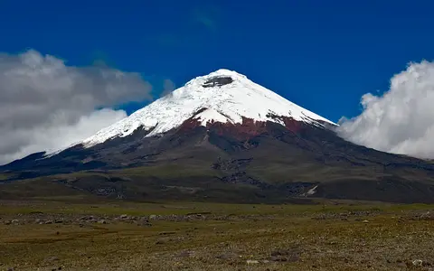

An ice-capped Andean cone
Cotopaxi adds a tropical high-volcano record where cone form, summit ice, ash deposits, and debris-flow pathways are tightly connected.
What Cotopaxi is
Cotopaxi is a high stratovolcano in the northern Andes. Its shape is defined by cone geometry, a summit crater, ice cover, and volcanic deposits.
The record links volcanic construction to high-elevation climate and drainage pathways.
Summit crater, slopes, and lahars
Ice on the upper cone can interact with volcanic heat and loose deposits. Valleys around the volcano preserve the physical importance of lahar routes.
Crater and ice
High volcanic terrain supports a frozen upper surface.
Layered volcanic slopes
Lava and ash build the cone outward.
Andean setting
Cotopaxi belongs to a major volcanic mountain belt.
A volcanic cone within the Ecuadorian Andes
Cotopaxi stands in Ecuador’s Cordillera Oriental, also called the Cordillera Real. The Instituto Geofísico places it approximately 35 kilometres northeast of Latacunga and 45 kilometres southeast of Quito. Its surroundings include high páramo terrain and neighbouring volcanoes such as Rumiñahui, Sincholahua and Quilindaña. This setting connects the individual cone to the wider landscape of the Andes, rather than presenting it as an isolated mountain.
The Instituto Geofísico describes a roughly symmetrical cone with a basal diameter of about 20 kilometres and slopes reaching 35 degrees. Those dimensions help explain the contrast between the broad volcanic base and the steep upper mountain. The summit crater, glacier-covered slopes and surrounding uplands are different parts of the same landscape, but each records different processes. The cone reflects volcanic construction, while ice and drainage affect how material moves across its surface. Understanding Cotopaxi therefore requires looking beyond its familiar silhouette to the terrain around its foot. Source: Instituto Geofísico’s Cotopaxi profile.
Construction, collapse and the summit craters
Cotopaxi’s present cone is one stage in a longer geological history. The Smithsonian Global Volcanism Program describes the modern edifice as having developed after a major collapse that occurred sometime before about 5,000 years ago. Its apparently regular shape should therefore not be read as evidence of uninterrupted growth or an unchanging mountain.
The summit contains nested craters, while large andesitic lava flows extend toward the base. Deep valleys cut by lahars radiate outward from the upper volcano. Together, these features show both the addition of volcanic material and its subsequent removal or redistribution. The summit, flanks and valleys preserve complementary evidence of how the landscape developed.
Explosive eruptions have also produced pyroclastic flows. The Smithsonian notes that historical descriptions sometimes confused these with lava flows. That distinction matters when interpreting the landscape: a record of a hot flow descending the mountain does not necessarily describe molten lava. Cotopaxi’s history includes several kinds of moving volcanic material, with different deposits and consequences. Source: Smithsonian Global Volcanism Program.
How summit ice contributes to lahars
Cotopaxi’s glacier cover is part of its volcanic behaviour as well as its appearance. The Instituto Geofísico’s public information leaflet explains that hot pyroclastic flows can melt part of the glacier during an explosive eruption. The released water can mix with rocks and finer volcanic debris, generating lahars that descend from the mountain. The leaflet identifies the eruption of 26 June 1877 as an example of this connection between hot flows, glacier melting and destructive sediment-laden water.
The same source distinguishes these eruption-related, primary lahars from secondary lahars. Secondary flows generally develop when intense or persistent rainfall saturates pyroclastic deposits on the flanks. This distinction explains why the presence of loose volcanic material matters even when a flow is not being triggered directly by an eruption.
Ice, water and debris consequently form a connected system. Describing the summit ice alone misses the downstream process: material released high on Cotopaxi can become part of a flow moving through its drainage network. Source: Instituto Geofísico’s Cotopaxi leaflet.
Why the valleys belong in the volcano record
A lahar is a moving mixture of water and volcanic debris, rather than a stream of molten rock. The US Geological Survey describes lahars as masses of rock, mud and water driven downslope and downstream by gravity. Steep volcanic slopes provide loose material, while rain, snow or ice can supply water. These general processes help explain why a volcano record needs to include drainage pathways alongside the crater and cone.
Lahars can travel far downstream through valleys. Their geographical footprint can therefore extend beyond the steep slopes that visually define a volcano. Reading the landscape involves following the connections from upper slopes into channels and onward through the river system, rather than considering distance from the summit alone.
The USGS explanation is based on Cascade volcanoes and provides a comparison of physical processes; it does not establish the extent of a particular Cotopaxi flow. It nevertheless clarifies the central distinction in this record: the mountain is the source area, while connected valleys can convey water and volcanic sediment into the surrounding landscape. Source: USGS explanation of lahars.
Sources
- Instituto Geofísico, Escuela Politécnica Nacional — Cotopaxi: location, surrounding terrain and cone morphology.
- Smithsonian Global Volcanism Program — Cotopaxi: geological summary, summit craters and eruptive landforms.
- Instituto Geofísico, Escuela Politécnica Nacional — Volcán Cotopaxi public information leaflet: glacier melting, the 1877 eruption and primary and secondary lahars.
- US Geological Survey, Cascades Volcano Observatory — Lahars: general flow processes and downstream transport, used as comparative explanation.