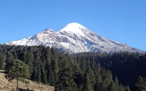

What Pico de Orizaba is
Pico de Orizaba is a stratovolcano on the plateau margin on the eastern margin of the Mexican highlands. Its relief is expressed as a tall volcanic cone with an open summit crater, steep upper slopes, and broader lower aprons of lava, ash, and reworked volcanic sediment.
The mountain belongs to the Trans-Mexican Volcanic Belt, a chain of volcanic terrain that crosses eastern Mexico from the Pacific side toward the Gulf-side interior. In atlas terms, Pico de Orizaba is both a volcanic landform and a high-relief mountain record because its shape, drainage, and regional setting are controlled by volcanic construction.
Highland position and regional extent
The volcano rises on the Puebla–Veracruz boundary, west of Orizaba, with its flanks reaching across the border area of Puebla and Veracruz states. It is associated with Sierra Negra to the south, near the descent from Mexico's interior plateau toward the Gulf lowlands.
This position matters physically because Pico de Orizaba sits near densely dissected uplands rather than on an isolated plain. Ridges, barrancas, and radial drainages carry volcanic sediment away from the cone toward surrounding valleys, while the high summit intercepts cooler air above the warmer plateau margins.
Crater, flanks, and volcanic materials
Pico de Orizaba has the steep-sided profile typical of a stratovolcano. Lava flows add resistant surfaces to parts of the cone, while ash, scoria, and other fragmental deposits create loose layers that can be remobilized by rain, snowmelt, or eruption-fed runoff.
The summit crater is the main topographic focus of the edifice. Around it, upper slopes descend through gullied volcanic terrain to lower aprons where older flows, ash beds, and debris-flow deposits merge with the broader highland surface.
Crater structure
The crater marks the active volcanic core and organizes the upper cone.
Layered slopes
Lava and loose pyroclastic material build steep radial terrain.
Arc setting
The volcano is part of Mexico's cross-country volcanic belt.
Drainage, elevation, and debris-flow corridors
Pico de Orizaba's height creates sharp climate contrasts between summit, slope, and basin. The highest northern slopes retain shrinking glacier ice, while lower slopes experience stronger seasonal rainfall controls from the eastern Mexican highland climate.
Hydrology on the volcano is mainly radial. Water moves down ravines and valley heads cut into the cone, carrying ash and loose volcanic sediment where channels are steep enough. These corridors are important physical features because they connect summit processes to lower valleys through lahars, muddy floods, and sediment pulses.
Volcanic belt and basin connections
The volcano helps define the highland boundary between major eastern Mexican basins. Its relief affects local drainage divides, sediment supply, and the visual structure of the surrounding plateau landscape.
Within Geography Atlas, Pico de Orizaba is best read alongside other volcano records and the broader mountains hub, because its physical geography depends on both volcanic process and mountain-scale relief.