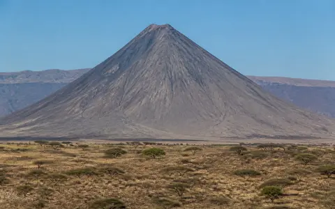
What Ol Doinyo Lengai is
Ol Doinyo Lengai stands in Arusha Region about 20 kilometres south of Lake Natron. Its cone rises abruptly from a broad rift-floor plain, creating much greater local relief than its summit elevation alone suggests. The mountain marks the northern edge of the volcanic highlands that continue south toward Kerimasi and the Ngorongoro crater country.
The edifice is broadly symmetrical from a distance, but its summit and flanks preserve a more complex history. Two summit depressions lie on either side of a high ridge, older lava and tephra make up most of the outer cone, and erosion has cut gullies into the steep slopes. The name Ol Doinyo Lengai is commonly translated from Maa as “Mountain of God,” but the defining physical feature is its position as a young volcanic cone on the floor of an actively extending continental rift.
Twin craters on a layered cone
The southern crater is the older, broader summit depression and is no longer the main focus of activity. North of the intervening summit ridge, the active crater has repeatedly changed depth and outline. Explosive eruptions can excavate a steep-walled pit and build an ash cone; quieter periods add thin lava flows, small spatter cones called hornitos, and new layers across the crater floor.
Despite the volcano's association with carbonatite, most of the mountain consists of silicate volcanic rock, especially phonolitic and nephelinitic lava, tuff, and agglomerate. Natrocarbonatite forms a much smaller but highly distinctive part of the recent summit record. It erupts at lower temperatures and with lower viscosity than familiar basaltic lava, appearing dark when fresh before weathering rapidly to pale gray or white carbonate minerals.
Southern crater
A broad, subdued depression associated with the earlier cone-building history.
Northern crater
A changing pit and crater floor shaped by collapse, ash eruptions, hornitos, and small lava flows.
Lava, tephra, and gullies
Layered silicate deposits form the steep cone and are increasingly dissected downslope.
Seasonal runoff into a closed basin
Gullies radiate down Ol Doinyo Lengai's outer slopes, but most do not carry continuous flow. Rainfall is seasonal, and porous lava, loose ash, and fractured volcanic deposits absorb part of the water. Intense storms can nevertheless produce short-lived runoff that erodes ash-covered slopes, moves sediment onto the lower aprons, and feeds ephemeral channels across the rift floor.
The volcano stands within the wider Lake Natron catchment. Drainage on the surrounding basin floor is generally graded northward toward the shallow lake, which has no outlet to the sea. Water is lost mainly through evaporation, while rivers, seasonal streams, groundwater, and hot springs replenish the basin. Ol Doinyo Lengai therefore connects upland volcanic relief to an internal drainage system rather than to a through-flowing regional river.
Dry rift lowlands and a cooler summit
The Lake Natron lowlands are hot and semi-arid to arid. Rain falls irregularly, mainly during the warmer wet-season months, and annual evaporation commonly exceeds local rainfall. Long dry intervals limit permanent channels, expose lake-margin mud and salt flats, and leave much of the lower volcanic terrain sparsely covered.
Conditions cool with elevation on the cone, and rising air can produce more cloud and rainfall on the upper slopes than on the basin floor. Even so, the mountain lacks the persistently wet summit climate of higher East African massifs. Alternation between dry weather and sudden rain helps break down loose tephra, deepen radial gullies, and rapidly hydrate and alter the sodium-rich surfaces of fresh carbonatite lava.
A volcano within the Natron Rift
Ol Doinyo Lengai lies in the Gregory Rift, the eastern branch of the East African Rift system. Normal faulting has lowered the Lake Natron basin between uplifted blocks and volcanic highlands, creating the north–south corridor in which the cone stands. Lake Natron lies to the north, Gelai volcano rises beyond the basin to the east, and the Crater Highlands form higher volcanic ground to the south.
Rifting provides pathways for alkaline magma to rise through continental crust, but local magma evolution gives Ol Doinyo Lengai its exceptional carbonate-rich eruptions. Within the volcanoes hub, the mountain complements Mount Kilimanjaro, a much larger East African Rift massif, and Mount Nyiragongo, a western-rift cone whose fluid silicate lava descends toward the Lake Kivu basin.