
What Mount Nyiragongo is
Mount Nyiragongo rises north of Goma and Lake Kivu in North Kivu Province. It forms part of the Virunga chain, a group of volcanic mountains extending across the border region of the Democratic Republic of the Congo, Rwanda, and Uganda. The neighboring Nyamuragira shield volcano lies to the northwest, while older Virunga cones continue eastward.
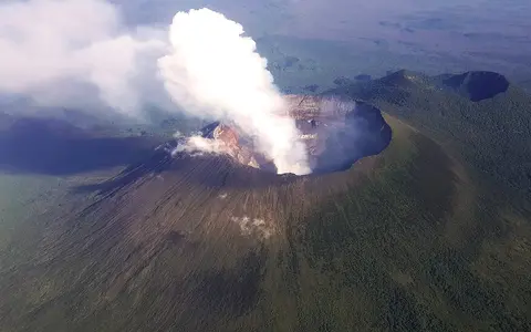
The mountain is a compact, high-relief volcanic edifice rather than a broad shield. Its upper slopes converge on a summit crater about 1.2 km across. Within that depression, successive collapses and changes in lava level have produced nested crater walls and terraces. A lava lake has occupied the crater intermittently for long periods, reflecting an open volcanic conduit rather than a permanent surface feature.
Summit crater, flank cones, and lava routes
Nyiragongo's main cone is built from lava and fragmental volcanic material around a central vent. The steep upper edifice includes two prominent older cones: Baruta on the northern flank and Shaheru on the southern flank. Smaller cones and eruptive fissures extend away from the summit, adding local ridges and depressions to the lower slopes.
The volcano's silica-poor, alkali-rich lavas can be exceptionally fluid. When magma drains from the crater or erupts through flank fissures, flows can move rapidly down the steep southern slope and spread across gentler ground near Goma. The 1977 and 2002 eruptions demonstrated this summit-to-basin connection, while the 2021 eruption again opened fissures on the southern flank.
Broad crater and inner terraces
Collapse scarps and ledges record changing crater floors and repeated drainage of lava.
Cones and eruptive fissures
Satellite cones and cracks interrupt the otherwise steep radial slopes.
Overlapping lava fields
Young flows descend southward and fan across the high basin near Lake Kivu.
Permeable slopes above the Lake Kivu basin
Although the mountain receives abundant rain, young fractured lava and porous volcanic deposits allow much water to infiltrate. Surface drainage is therefore less continuous than the steep relief alone might suggest. Short channels occupy some older or less permeable surfaces, but fresh lava fields can disrupt them, create enclosed hollows, and redirect runoff around flow margins.
The southern flank descends into the Lake Kivu basin, part of the rift-floor drainage system. Lake Kivu drains southward through the Ruzizi River toward Lake Tanganyika, so Nyiragongo stands above a regional chain of connected basins. On the volcano itself, however, groundwater movement through fractured lava is an important complement to visible streams.
Equatorial moisture shaped by elevation
Nyiragongo lies close to the Equator, but its climate changes markedly with height. The lower basin is comparatively warm, while rising air, frequent cloud, and reduced temperatures make the upper slopes cool and wet. Rain falls in much of the year, with seasonal peaks as tropical rain belts migrate across the region.
Elevation and slope exposure influence cloud cover, weathering, vegetation, and runoff. Moisture supports dense cover on many older surfaces, whereas recent lava remains bare or thinly colonized. This contrast makes the age and texture of flows visible in the landscape and affects how quickly rainfall infiltrates or moves downslope.
Volcanism in the Albertine Rift
Nyiragongo belongs to the Virunga volcanic province within the Albertine Rift, the western branch of the East African Rift system. Extension and faulting have formed elongated basins and uplifted bordering highlands, while magma rising through the stretched crust has built the Virunga volcanoes across the rift zone.
The volcano's steep central cone contrasts with nearby Nyamuragira's broader shield form, even though both erupt silica-poor lava. Within the volcanoes hub, Nyiragongo also complements Mount Kilimanjaro, another East African Rift volcanic massif whose multiple cones, glaciated summit remnants, and much larger footprint produce a different highland landscape.