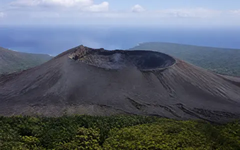
What Mount Yasur is
Mount Yasur stands near the southeastern coast of Tanna, an island about 40 kilometres long in the southwest Pacific. Although it is commonly described as a mountain, Yasur is only the youngest and most visibly active part of a larger volcanic system. Its cone sits inside the Siwi caldera, near the western end of the raised Yenkahe block and northeast of the older, much higher Tukosmeru volcanic massif.
The cone is about 1.5 kilometres across at its base and rises to 361 metres above sea level. Persistent eruptions have built steep upper slopes from loose ejecta, but the surrounding caldera floor is comparatively low and broad. The contrast between cone, basin floor, ash plain, uplifted block, and nearby coast makes the wider Yasur–Yenkahe complex more geographically informative than the summit alone.
Crater rim above a broad ash plain
Yasur's upper surface converges on a nearly circular summit crater about 400 metres wide. Within it, smaller craters and vents are arranged along a general northeast–southwest line. Their outlines change as explosions excavate vent walls and return scoria, bombs, and ash to the crater floor and rim. The resulting crest is irregular rather than a single pointed summit.
Outside the crater, steep, mostly unvegetated slopes descend to a wider base made from overlapping fall deposits, talus, and material from earlier flank failures. The western and northern foot of the cone grades toward a broad ash plain on the caldera floor. This low surface receives much of Yasur's fine ejecta and makes the volcano appear as a compact cone rising from a dark, sediment-filled basin.
Compound crater
A broad main crater encloses several smaller vents whose shapes change with continuing activity.
Loose pyroclastic slopes
Scoria, ash, lapilli, bombs, and talus create steep surfaces that are readily reworked.
Caldera-floor ash plain
Repeated ash fall has filled and smoothed low terrain west and north of the cone.
Yasur beside the rising Yenkahe block
The Siwi caldera is an elongated collapse structure roughly 9 kilometres long and 4 kilometres wide. Its ring fracture crosses southeastern Tanna and continues toward the coast, so the basin is not expressed everywhere as one simple, continuous wall. Older ignimbrite and other pyroclastic deposits record major eruptions that formed the collapse landscape before the modern Yasur cone developed.
Inside the caldera, the Yenkahe block forms a fault-bounded area of uplift about 6 by 3 kilometres. Raised reef terraces on its coastal side show that ground once near sea level has been lifted well above the present shore. Yasur lies along the western side of this resurgent structure. The juxtaposition of an erupting cone and an uplifting caldera block reveals two surface responses to continuing magma supply: fragmental material accumulates at the vents while deeper intrusion deforms the surrounding basin floor.
Scoria cone, ash sheets, and older ignimbrite
Yasur is built mainly from basaltic-andesite to andesite eruptive products. Coarse bombs and scoria tend to fall near the vents, adding to the rim, upper cone, and talus at the base. Finer lapilli and ash spread farther across the caldera floor and beyond it, with the direction and reach of each deposit controlled partly by wind and eruption intensity.
The ash plain records repeated filling rather than one single event. Thin beds can bury older surfaces, while heavy rain cuts channels and sorts loose particles by size. Beneath these young deposits lie older lava, ignimbrite, tuff, and collapse-related units belonging to the wider Siwi system. Erosion therefore exposes a layered sequence in which the continuing activity of Yasur rests on a far longer history of caldera eruption, subsidence, uplift, and sediment redistribution.
Rainfall, former Lake Siwi, and an outlet to the coast
There is no permanent stream descending from the crater. Rain falling on the cone enters porous ash and scoria or runs quickly down short gullies, carrying loose sediment onto the caldera floor. Because the low ground is partly enclosed by volcanic relief and has been repeatedly dammed by eruptive material, drainage has changed as deposits accumulated and barriers were breached.
For many years the Siwi River fed shallow Lake Siwi on the ash plain west of Yasur. After unusually heavy rain in 2000, water broke through its natural volcanic dam and cut a new outlet toward Sulphur Bay. The lake largely drained, and the flood incised a deep channel through layered tephra. This event left a clear physical connection between tropical rainfall, basin storage, erodible volcanic sediment, and the eastern coast of Tanna.
Tropical maritime weather over exposed ash
Southeastern Tanna has a tropical maritime climate moderated by the surrounding Pacific. Temperatures remain warm through the year, with a warmer, wetter season generally extending from November to April and a somewhat cooler, drier period from May to October. Humid southeast airflow supplies frequent rain to the windward side of the island, while the South Pacific Convergence Zone and tropical cyclones can bring much heavier episodes.
Climate acts directly on Yasur's loose surfaces. Intense rain compacts and erodes fresh ash, cuts rills into the cone and plain, and transfers fine sediment into the Siwi drainage. Wind carries dry ash away from the crater and redistributes older material across exposed ground. The low summit does not create a separate high-mountain climate; instead, local contrasts are governed mainly by wind exposure, vegetation cover, rainfall, and proximity to the coast.
A young vent in the Vanuatu island arc
Tanna belongs to the southern part of the Vanuatu volcanic arc, land built above a subduction zone where the Australian Plate descends beneath the arc. Yasur is one of several active volcanic centers along this north–south chain. On Tanna itself, the young Siwi volcanic group overlaps older terrain produced by the Green Hill and Tukosmeru centers, placing the active cone at the southeastern edge of an island assembled through several stages of volcanism.
Persistent explosive activity continually refreshes the crater and adds material to the cone and ash plain, but regional structure determines where that material accumulates. The caldera supplies the basin, the Yenkahe block creates uplifted relief, the Siwi River connects low ground to Sulphur Bay, and the island arc explains the underlying magma supply. Within the volcanoes hub, Yasur complements Mount Bromo as a young cone inside an older caldera and Stromboli as a persistently active cone whose frequent explosions reshape a compact summit area.