Location and physical setting
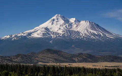
Mount Shasta stands in Siskiyou County, about 65 km south of the Oregon border. The main cone rises above Shasta Valley to the north and west, the upper Sacramento River corridor to the southwest, and the McCloud River country to the east and south. Its summit is at 41.409° N, 122.193° W.
The edifice has an estimated volume of about 350 km³. Its scale and relatively isolated position produce strong local relief above the surrounding valleys and volcanic uplands. Shastina, a subsidiary cone reaching 3,758 m, forms a broad western shoulder about 3 km from the main summit, while Black Butte's overlapping dacite domes stand farther west near the base.
Overlapping cones and volcanic aprons
Four major cone-building episodes constructed most of present Mount Shasta around closely spaced vents. Sargents Ridge, the oldest exposed main cone, is most visible on the south side. The younger Misery Hill cone forms much of the upper mountain. Shastina built the large western shoulder, and the still younger Hotlum cone forms the summit and much of the north and northwest flanks.
These cones consist mainly of andesite lava flows and fragmental deposits, followed in places by dacite domes and pyroclastic material. Erosion and glaciers cut gullies between resistant lava ridges, while rockfall, streamflow, and debris flows carried loose material downslope. On the lower mountain, lava, pyroclastic deposits, glacial sediment, and alluvium merge into wide fans and aprons.
Four main cones
Sargents Ridge, Misery Hill, Shastina, and Hotlum record separate construction stages around neighboring vents.
Ridges and glacial valleys
Ice and runoff have dissected the cone without erasing its broad volcanic profile.
Fans and hummocky terrain
Depositional aprons spread outward, while an older debris-avalanche deposit extends across Shasta Valley.
Glaciers, springs, and three river systems
Bolam, Hotlum, Konwakiton, Whitney, and Wintun glaciers occupy high valleys around the cone. Snow and glacier melt join seasonal precipitation in steep headwater channels. Many upper channels carry water only intermittently because fractured lava, lava tubes, and coarse fan deposits allow runoff to sink below the surface.
Groundwater reappears at numerous springs around the mountain's lower slopes. Surface drainage divides radially: streams on the northwest side enter the Shasta River, western and southwestern waters reach the Sacramento River, and eastern, southeastern, and southern streams feed the McCloud River. These connections place the entire mountain within the wider Sacramento River basin, but water and sediment reach it by several distinct routes.
Winter moisture and high-elevation snow
Mount Shasta lies within a climate shaped by Pacific storm tracks and California's dry-summer seasonal pattern. Most high-elevation precipitation arrives during the cool season, much of it as snow. Temperature falls rapidly with height, allowing snowfields and glaciers to persist around the summit while lower slopes experience warmer, drier summers.
The mountain's height also redistributes precipitation. Air rising over exposed slopes cools and releases rain or snow, while leeward areas receive less moisture. Differences in snow accumulation, melt timing, and groundwater storage help explain why neighboring radial channels can have very different flows. Freeze-thaw weathering and summer melt loosen and move volcanic debris through the upper ravines.
The southern Cascade volcanic arc
Mount Shasta lies near the southern end of the Cascade volcanic arc, north of the Lassen volcanic region and west of the broad Medicine Lake shield volcano. The arc is related to subduction of the Juan de Fuca and Gorda oceanic plates beneath North America along the Cascadia margin. At Mount Shasta, this regional setting has produced long-lived andesite-dacite volcanism concentrated around a cluster of central and flank vents.
The mountain's physical footprint extends beyond its cone. An ancestral edifice collapsed between about 380,000 and 300,000 years ago, sending a debris avalanche at least 45 km north-northwest across Shasta Valley and leaving hummocky terrain. Younger eruptions and slope failures produced lahars that spread across basal fans and entered the McCloud and Sacramento valleys. In the atlas, this combination of overlapping cones, ice, and far-reaching sediment routes can be compared with Mount Rainier and Mount Hood.