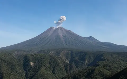
What Mount Semeru is
Mount Semeru rises in the volcanic highlands of East Java. It is the southernmost major edifice in the Tengger–Semeru chain, a north–south group of calderas, older cones, and younger volcanic landforms. The high cone stands above an extensive ring plain and creates a sharp relief transition from bare upper slopes to dissected middle flanks and lower valleys.
In physical geography terms, Semeru is a compound construction rather than a perfectly regular cone. The older Mahameru edifice forms much of the mountain, while the younger active summit cone has grown against it. Repeated lava extrusion, explosions, slope failure, erosion, and sediment transport continue to modify the summit and the valleys below.
Older edifice, young cone, and southeast scar
Semeru's upper landform consists of overlapping volcanic units. The younger cone carries the active Jonggring-Seloko crater just southeast of the Mahameru high point. The crater and a larger horseshoe-shaped summit scar open toward the southeast, interrupting the cone's radial symmetry and concentrating loose material in that sector.
To the north, the edifice is buttressed by the older Jambangan complex and merges into the broader Tengger–Semeru uplands. To the south and southeast, long exposed slopes descend over older volcanic and sedimentary foundations. This contrast gives Semeru a connected highland side to the north and a more open, deeply channelled apron toward the lower southern terrain.
Mahameru summit
The summit forms Java's highest topographic point and stands immediately northwest of the active crater.
Jonggring-Seloko
The summit crater occupies the younger cone and opens into the volcano's southeast-facing sector.
Jambangan connection
Older volcanic terrain links Semeru northward to the calderas and cones of the Tengger massif.
Radial drainage and sediment-rich valleys
Drainage begins in gullies on the upper cone and becomes concentrated in steep radial valleys farther downslope. The southeast sector contains several of the most important channels, including the Besuk Kobokan, Besuk Kembar, Besuk Bang, and Besuk Sat systems. Their headwaters align with the open crater sector and receive large quantities of ash, blocks, and other volcanic debris.
Heavy rain can remobilize this loose material as sediment-rich floods and lahars. The channels are therefore both drainage routes and major landform-building corridors: they erode the cone, widen or shift across lower slopes, and spread sand, gravel, and boulders onto the ring plain. Other catchments drain the western and southern flanks, linking Semeru's summit relief to river systems descending toward southern Java.
Monsoon rainfall and elevation gradients
Semeru has an equatorial monsoon setting, with a wetter part of the year under rain-bearing westerly circulation and a generally drier period when easterly winds are more persistent. The high cone intercepts moist air and produces strong local differences in cloud and rainfall. Studies of the eastern and southeastern flanks have recorded annual totals of roughly 2,000 to 3,700 millimetres.
Temperature decreases from the low ring plain toward the exposed summit. Upper slopes are cooler, windier, and often cloud-covered, while intense rainfall is especially important at middle elevations. This combination of steep gradient, concentrated storms, and abundant loose debris makes climate a direct control on channel incision and the movement of volcanic sediment.
The Tengger–Semeru massif and Sunda Arc
Semeru forms the southern end of a volcanic massif extending north toward the Tengger caldera. The connection is visible in the sequence of highlands between Semeru, the Jambangan complex, and the caldera terrain surrounding Mount Bromo. Bromo is a small cone on a caldera floor; Semeru provides the contrasting form of a much larger, high-relief stratovolcano at the end of the same regional volcanic alignment.
At the plate scale, Semeru belongs to the Sunda Volcanic Arc above the subduction zone south of Java. Magma generated in this tectonic setting has built a long chain of volcanoes across the island. A comparison with Mount Merapi shows how two active Java cones share monsoon-controlled lahar systems while differing in summit structure, scale, and their relationship to neighbouring uplands.