What Mount Apo is
Mount Apo stands southwest of Davao City in the Apo–Talomo highlands of southern Mindanao. Its eastern and southern flanks descend toward the Davao Gulf side of the island, while drainage from the western and northwestern slopes enters the broad interior river network of the Cotabato Basin. This position makes the massif both a major center of relief and a regional watershed divide.
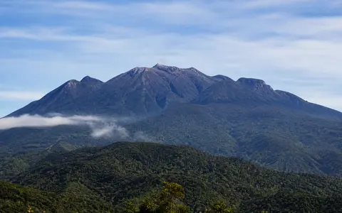
Apo is a composite volcano, but its outline is more complex than that term alone suggests. The volcanic complex contains four main edifices and several smaller cones, with the Apo dome identified as its youngest major feature. Older volcanic surfaces have been overlapped, weathered, and cut by valleys, producing a wide, irregular mountain mass whose highest ground is concentrated around the modern summit area.
Overlapping edifices and a broad summit
The volcanic complex is built mainly from andesite, basaltic andesite, and dacite. These rocks record repeated episodes in which relatively viscous lava, domes, and fragmental material accumulated around neighboring vents. Instead of forming one uninterrupted cone, the deposits created overlapping constructional landforms that merge into the wider Apo massif.
The summit is flat-topped at regional scale and carries three principal peaks. The southwestern peak is the highest point and includes a crater about 500 m wide with a small lake. A younger crater lies on the northern peak. Ridges, hollows, lava-built surfaces, and eroded shoulders connect the summit features to lower slopes, so the massif becomes increasingly dissected away from its central high ground.
Three-peak crest
Closely grouped high points and crater rims give Apo a broad summit profile rather than a sharp apex.
Nested volcanic landforms
Multiple edifices, cones, and a younger dome preserve construction from more than one vent area.
Dissected volcanic slopes
Weathering, runoff, and valley cutting have reshaped lava and fragmental deposits around the massif.
From summit plateau to basin margins
Apo rises high above the surrounding terrain, but the descent is not uniform. Near the summit, crater rims and rocky peaks interrupt relatively compact high ground. Farther out, long spurs separate steep ravines, and the relief broadens into foothills shared with the larger Apo–Talomo upland. This compound form makes the volcano appear massive from the lowlands even where no single flank preserves a smooth cone.
To the east, the mountain forms the elevated inland backdrop to plains and valleys leading toward Davao Gulf. Westward, its slopes face the Cotabato Basin and the extensive lowland system drained by the Pulangi and Mindanao rivers. The result is a strong topographic transition across the massif: maritime-facing slopes on one side, an interior basin connection on the other, and a high divide between them.
Crater water, springs, and radial rivers
Water occurs at several scales on Mount Apo. A small lake occupies the crater on the southwestern summit peak, while springs and seepage emerge where groundwater meets fractures or less permeable volcanic layers. There is no permanent summit ice, so rain, cloud moisture, and groundwater provide the main inputs to the drainage system.
Streams radiate outward from the high ground and become confined in deeply incised valleys. On the northwest flank, the Matingao and Marbel catchments drain toward the Pulangi River system, which continues through the Mindanao River to the coast of the Cotabato region. Other headwaters descend east and south through catchments directed toward the Davao Gulf lowlands. These contrasting routes show how Apo connects short mountain channels with river networks operating across much larger basins.
Volcanic rock and relief control the movement of water. Fractured lava can accept infiltration, while ash-rich or weathered layers may slow it and encourage spring flow. During intense rain, steep channels carry runoff and eroded sediment downslope; during quieter periods, stored groundwater helps maintain springs and upper river flow.
Humid tropical air lifted over high terrain
Mount Apo stands within a warm tropical region but creates a pronounced elevation gradient. Air cools as it rises along the massif, encouraging cloud formation and orographic rain. Temperatures are therefore lower near the summit than in the surrounding lowlands, and cloud, mist, and frequent surface moisture become important features of the upper slopes.
The mountain's size also produces local contrasts. Moist air approaching from the Davao Gulf side can be lifted across the eastern and southern flanks, while exposure, wind direction, and rain-shadow effects vary around the summit divide. Repeated wetting supports chemical weathering of volcanic rock, soil formation, and continued incision of the radial ravines. Short episodes of heavy rain can move far more sediment than ordinary streamflow, especially on steep or disturbed slopes.
Solfataras and geothermal circulation
A line of solfataras follows a fissure on the southeastern side of the summit and continues for about one kilometre downslope. These vents release steam and volcanic gases through fractured ground. Hot springs around the complex provide further surface evidence that groundwater circulates through warm rock below the massif.
These features do not by themselves indicate an imminent eruption. No confirmed Holocene eruption is known from Apo, and reports have sometimes confused it with other Mindanao volcanoes. Geographically, the thermal areas are best understood as part of the mountain's hydrothermal system: rainwater enters the fractured edifice, is heated at depth, and returns along permeable faults and fissures.
Central Mindanao volcanic province
Mount Apo belongs to the Mindanao Volcanic Province, within a part of the Philippines where several crustal blocks, volcanic belts, faults, and subduction systems meet. Its magma composition and composite landforms are consistent with subduction-related volcanism, but the regional history is more complicated than a direct link to a single modern trench. Geological studies describe central Mindanao as an area shaped by arc collision, later deformation, and magmatism above previously subducted oceanic crust.
At landscape scale, Apo links the volcanic uplands of southern Mindanao with both the Cotabato interior and the Davao Gulf margin. Within the atlas, it offers a useful contrast with the near-regular cone and short coastal drainage of Mount Mayon and the caldera-and-lahar landscape of Mount Pinatubo. Together, the records show that Philippine volcanoes can form isolated cones, collapse basins, or broad compound massifs according to their construction, erosion, climate, and regional setting.