The range is not the whole volcanic province
Sierra Madre Occidental is the accepted Spanish name used by Mexico's Instituto Nacional de Estadística y Geografía (INEGI); the literal English rendering “Western Sierra Madre” is a translation, not a separately bounded feature. INEGI describes the physiographic province as running northwest–southeast from the international boundary with Arizona to the Río Grande de Santiago in Nayarit. Geological literature often places the southern transition at the Trans-Mexican Volcanic Belt. Both describe a gradual junction rather than a surveyed endpoint. (INEGI, Mexico Today, pp. 8–9; Ferrari and others, 2005)
The geological synthesis defines the traditional physiographic province as approximately 1,200 km long, 200–400 km wide, and averaging more than 2,000 m in elevation. A vegetation study used a narrower mapped study region of about 1,160 km, with coordinate extremes 30°35′–21°00′ N and 109°10′–102°25′ W. Those coordinates enclose that study's regional polygon; they are not a single point coordinate for the elongated range. Its different endpoints explain why the two rounded lengths should not be averaged together. (Ferrari and others, 2005; González-Elizondo and others, 2012)
The same name also denotes a Cenozoic volcanic province—called “Tertiary” in older sources—that extends east beyond the physiographic range into the Mesa Central and eastern Chihuahua. This page covers the physical mountain province, while using the wider volcanic province only when a cited geological measurement explicitly describes it. Sierra Tarahumara is a regional name for part of the northern highlands, and names such as Sierra de Parral, Tepehuanes and Sierra de Bayas apply to local sectors; none is an alias for the full 1,200-km system. (Servicio Geológico Mexicano, Volcanes de México)
A high surface cut from the west and broken at its margins
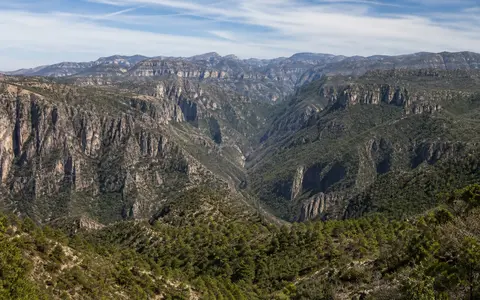
Much of the interior is a broad tableland rather than a single ridge. Gently rolling uplands and mesas preserve remnants of resistant volcanic sheets; transverse valleys and fault-bounded basins interrupt that surface. The western side descends abruptly toward Sonora, Sinaloa and Nayarit, whereas the east commonly steps into higher interior basins. “Plateau elevation” and local relief therefore describe different things: a surface above 2,000 m can stand beside a canyon floor more than a kilometre lower.
Rivers flowing toward the Pacific margin have cut branching barrancas—deep, steep-sided valleys—through the volcanic cover and into older basement. A continent-scale synthesis reports 1–2 km of post-Oligocene fluvial incision into west-coast ignimbrites, based on published geomorphic measurements; this is a regional incision range, not the depth of every canyon. Its river-profile modelling also treats the landscape as transient, with uplift and erosion changing through the Cenozoic. (Stephenson and others, 2014)
In southwestern Chihuahua, “Copper Canyon” or Barrancas del Cobre is a collective label for several connected barrancas within the Sierra Tarahumara, not one gorge extending along the whole range. The plateau-and-canyon contrast continues south through Durango and Nayarit, but canyon geometry, bedrock exposure and incision history differ among drainage basins. For that reason this page does not repeat unsourced claims that the complex is universally “larger” or “deeper” than another canyon.
Two ignimbrite pulses above an older volcanic arc
The basement and volcanic pile record several distinct episodes, not one eruption. Ferrari and colleagues group Late Cretaceous–Paleocene plutonic and volcanic rocks with Eocene andesites and lesser rhyolites in the older Lower Volcanic Complex. Above them lies the Upper Volcanic Supergroup, dominated by silicic ignimbrites—rock formed when hot, ash-rich pyroclastic density currents settled, compacted and commonly welded. The principal compiled emplacement intervals are 32–28 million years ago and 24–20 million years ago. (Ferrari and others, 2005)
That synthesis estimates the wider silicic cover at approximately 1,200 km long and 250 km wide on average, locally more than 1,000 m thick, with an erupted volume near 300,000 km³. The last number is a published order-of-magnitude geological estimate for the volcanic cover, not the volume of the present mountain range or a modern terrain-model calculation. Canyon walls expose older andesitic rocks, intrusions and basement where erosion has cut through the ignimbrites.
The magmatism developed during changing subduction of the Farallon plate beneath North America. Extension began by Oligocene time in the east and migrated westward; normal faults produced grabens—down-dropped crustal blocks—and tilted domains. By the late Miocene, deformation was concentrated nearer the future Gulf of California. The present landform therefore combines construction by arc volcanism, disruption during crustal stretching, and long river incision rather than representing a currently active line of giant calderas.
Arc rocks and intrusions
Cretaceous–Eocene volcanic and plutonic units underlie much of the younger ignimbrite cover.
32–28 and 24–20 Ma
Two concentrated eruptive intervals spread extensive silicic ash-flow sheets across western Mexico.
Faulting and incision
Crustal extension broke the margins into blocks while rivers cut through the elevated volcanic surface.
Pacific, Atlantic-linked, and closed-basin headwaters
The range is a broad source region rather than a perfectly continuous two-sided divide. On the west, headwaters feed the Yaqui, Mayo, Fuerte, Humaya–Culiacán, Presidio, Baluarte, San Pedro–Mezquital and Acaponeta systems before crossing the coastal lowlands to the Gulf of California or Pacific Ocean. At the southern end, tributaries also enter the Río Grande de Santiago. Mexico's national biodiversity commission maps the upper basins through Sonora, Chihuahua, Sinaloa, Durango, Nayarit, Zacatecas and Jalisco and explicitly distinguishes westward coastal drainage from eastward drainage toward the Altiplano. (CONABIO hydrological-regions map and notes; González-Elizondo and others, 2012)
Across the northern continental divide, water from the same Sierra Tarahumara high country takes opposite routes: the western side enters the Fuerte basin, while the eastern side enters the Río Conchos–Río Bravo system. The Conchos rises in the Sierra Madre Occidental of Chihuahua, is rainfall-dominated, and joins the Rio Grande/Río Bravo near Ojinaga and Presidio before the combined river reaches the Gulf of Mexico. (Instituto Mexicano de Tecnología del Agua, Río Conchos basin account; Blythe and Schmidt, 2018)
Other eastern and northern slopes drain to closed basins: their streams terminate inland rather than reaching an ocean. The Casas Grandes, Santa María and Carmen systems end in northern basin lakes or playas, while the Nazas–Aguanaval system drains internally farther south. Thus “Pacific–interior divide” is useful shorthand only if the Río Bravo connection and the several endorheic basins remain explicit.
Warm-season rain moves from crest to lowland channels
The northern and central Sierra Madre Occidental lie in the core of the North American monsoon. A study of 15 unregulated headwater basins used Comisión Nacional del Agua streamflow observations to distinguish three coherent rainfall–runoff regions; it did not treat the entire range as hydrologically uniform. A related rain-gauge study reports that monsoon precipitation supplies roughly 50–80% of the annual water resource in the northwestern Sierra Madre region, with the proportion varying by place. (Gochis, Brito-Castillo and Shuttleworth, 2006; Gochis and others, 2007)
The NAME Event Rain Gauge Network sampled the mountain region from 2002 through 2004. It found frequent moderate precipitation centred over high terrain, while the largest hourly and daily events were concentrated at coastal and lower elevations west of the range. Rain tended to occur earlier and more often aloft and later—often evening or night—at lower elevations. These results describe the network domain and short observation period; they are process evidence, not a timeless rainfall total for all 1,200 km of the range. (Gochis and others, NERN paper and data tables)
Elevation cools the plateau relative to the low western canyons, but latitude and slope exposure modify the pattern. Northern and eastern foothills grade toward semiarid climates; the plateau carries cooler temperate conditions; lower western barrancas open into warm seasonally dry terrain. Convective rain generates sharp runoff pulses and moves sediment through the canyon network, while year-to-year and within-season variations alter how efficiently rain becomes streamflow.
Western wall of Mexico's interior plateau
Westward, the highland drops toward the Gulf of California and Pacific coastal plain, with lowlands grading into the Sonoran Desert in the north and warmer coastal terrain farther south. Eastward, high basins connect with the Mexican Plateau and the Chihuahuan Desert. These transitions are irregular: fault blocks, foothills and river corridors cross any simple boundary drawn around the range.
Southward, the physiographic province meets the younger, east–west Trans-Mexican Volcanic Belt near Nayarit and Jalisco. Northward, it approaches the international boundary through progressively broken ranges rather than continuing as one surveyed crest. The separate Sierra Madre Oriental forms the folded eastern rim of the Mexican Plateau; it should not be merged with this western volcanic highland despite the shared “Sierra Madre” name.
Data sources and publications
- Instituto Nacional de Estadística y Geografía (INEGI). Mexico Today: Geographic Aspects, 2000, pp. 8–9; accessed 30 August 2026. Official physiographic name, northwest–southeast orientation, Arizona-border to Río Grande de Santiago limits, and national province map.
- Ferrari, L., Valencia-Moreno, M., and Bryan, S. “Magmatismo y tectónica en la Sierra Madre Occidental y su relación con la evolución de la margen occidental de Norteamérica.” Boletín de la Sociedad Geológica Mexicana 57(3), 2005, 343–378. Physiographic-versus-volcanic scope, 1,200 km by 200–400 km dimensions, mean elevation, stratigraphic complexes, radiometric-age synthesis, ignimbrite thickness and volume estimate, and extensional history.
- Servicio Geológico Mexicano. Volcanes de México, accessed 30 August 2026. Accepted range name, general orientation, and local sector names; the page's alternate rounded dimensions are kept separate from the geological synthesis.
- González-Elizondo, M. S., González-Elizondo, M., Tena-Flores, J. A., Ruacho-González, L., and López-Enríquez, I. L. “Vegetación de la Sierra Madre Occidental, México: una síntesis.” Acta Botánica Mexicana 100, 2012, 351–403. Study-region length, coordinate envelope and elevation range; mapped regional limits; major drainages; and elevational and climatic transitions.
- Comisión Nacional para el Conocimiento y Uso de la Biodiversidad (CONABIO). Regiones hidrológicas prioritarias, map compiled 1998, 2nd ed., scale 1:4,000,000; accessed 30 August 2026. Sierra Madre headwater states, westward Pacific drainage, eastward Altiplano drainage, and northern Río Bravo or closed-basin connections.
- Instituto Mexicano de Tecnología del Agua. La cuenca del río Conchos: una mirada desde las ciencias ante el cambio climático, 2018, p. 161. Fuerte–Conchos continental divide through the Sierra Tarahumara and downstream connection to the Río Bravo.
- Blythe, T. L., and Schmidt, J. C. “Estimating the Natural Flow Regime of Rivers With Long-Standing Development: The Northern Branch of the Rio Grande.” Water Resources Research 54, 2018, 1212–1236. Río Conchos origin in the Sierra Madre Occidental, rainfall-dominated flow regime, and Ojinaga–Presidio confluence.
- Gochis, D. J., Brito-Castillo, L., and Shuttleworth, W. J. “Hydroclimatology of the North American Monsoon region in northwest Mexico.” Journal of Hydrology 316, 2006, 53–70. Fifteen-basin study design, monsoon rainfall–runoff response and subregional hydrologic differences.
- Gochis, D. J., Watts, C. J., Garatuza-Payan, J., and Cesar-Rodriguez, J. “Spatial and Temporal Patterns of Precipitation Intensity as Observed by the NAME Event Rain Gauge Network from 2002 to 2004.” Journal of Climate 20(9), 2007, 1734–1750; author manuscript and tables. Observation period, elevation classes, event intensity and timing, and monsoon share context.
- Stephenson, S. N., Roberts, G. G., Hoggard, M. J., and Whittaker, A. C. “A Cenozoic uplift history of Mexico and its surroundings from longitudinal river profiles.” Geochemistry, Geophysics, Geosystems 15, 2014, 4734–4758. ETOPO1 relief context, 533-profile method, published 1–2 km west-coast incision synthesis, and uplift-model limitations.