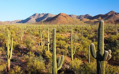

A region, not one surveyed landform
“Sonoran Desert” and Desierto Sonorense refer to a desert region, but the perimeter depends on whether a source maps vegetation, climate, physiography or an administrative study area. The National Park Service gives an approximate 260,000-km² transboundary frame. Mexican federal material uses a phytogeographic frame that includes most of Sonora west of the Sierra Madre Occidental, most of the Baja California peninsula and the Gulf of California islands.[1][2]
This record uses that broad physical-region sense. It does not treat the state of Sonora, the entire Baja California peninsula, the Gulf of California watershed, the U.S. Sonoran Desert physiographic section, or Mexico's physiographic province of the same name as interchangeable polygons. “Colorado Desert” is also used for the low California part of the larger Sonoran system in some U.S. classifications. The boundaries are therefore transitional rather than surveyed lines, and the area estimate is kept approximate.
No official centre coordinate is given. One NPS page prints a 23–30°N span while also placing the desert across southern Arizona; the Smithsonian locates the Pinacate field within the desert at 31.85°N. Because those statements cannot describe the same full extent, this page retains the mapped place descriptions and omits the inconsistent latitude range rather than manufacturing a centroid.[1][6]
Around the northern Gulf of California
In the United States, the desert occupies southeastern California and southern and western Arizona. The Mojave transition lies to the northwest and north; the Mogollon Rim and higher Arizona uplands bound or interrupt the northern side; and Chihuahuan drylands and grasslands approach from the east. South of the international border, the mainland sector extends across Sonora west of the Sierra Madre Occidental before grading into foothill thornscrub and tropical or montane forest toward the southeast.[1]
Across the Gulf of California, arid peninsular lowlands and Gulf-facing slopes continue south through Baja California and Baja California Sur, with the Pacific-side and high peninsular ranges forming different climatic settings. The gulf and its islands are therefore inside the regional geographic frame, but the sea itself is not desert land. Administrative borders locate the region; they do not define its natural edges.[2]
The lower Colorado River reaches the head of the gulf between the California–Baja and Arizona–Sonora sectors. This gives the desert an unusual plan: inland basins and mountain blocks flank a through-flowing river and a narrow marine rift, rather than surrounding one closed depression.
Fault blocks, basins and fan-built slopes
Much of the inland desert belongs to the southern Basin and Range province. In the U.S. Sonoran Desert physiographic section, a USGS regional aquifer study places valley floors from below 500 ft to above 2,500 ft (approximately below 150 to above 760 m) and mountain crests about 1,000–2,000 ft (300–610 m) above adjacent floors. The report gives altitudes above sea level but does not identify a vertical datum; its figures apply to that U.S. section, not the entire transboundary desert.[3]
Crustal extension and faulting separated uplifted blocks from subsiding basins. Erosion then supplied gravel, sand and silt to the lows. A stream leaving a confined canyon loses gradient and spreads sediment into an alluvial fan; adjoining fans merge into a bajada. A pediment is instead a gently sloping erosion surface cut across bedrock, even where a thin sediment cover hides it. These landforms should not be collapsed into the generic label “desert plain.”
Bedrock is equally varied. Precambrian crystalline rocks, younger sedimentary successions, intrusive bodies, volcanic rocks and Quaternary alluvium occur in different sectors. NPS synthesis associates widespread volcanism about 20–40 million years ago with the broader extensional landscape, but no single date is the “age of the Sonoran Desert.” Modern relief is the cumulative result of older rock construction, Cenozoic faulting and volcanism, and continuing erosion and deposition.[1]
Coalesced fan apron
A broad sediment slope built where neighboring alluvial fans meet below a range front.
Usually dry channel
A channel that may carry a short flood pulse after rain; “ephemeral” describes flow duration, not channel size.
Intermittently wet basin low
A fine-grained floor where water can pond and evaporate in a closed local basin; not every Sonoran basin ends in one.
Rifting opened the marine corridor
The Gulf of California edge has a different structural story from a simple fault-block basin. Geological reconstruction shows marine basins forming step by step as strike-slip and transtensional faults—faults combining sideways movement with extension—linked subsiding pull-apart basins. Marine water occupied a southern embayment by about 8 million years ago, advanced through central basins, and flooded more than 500 km of the northern rift by about 6.5–6.3 million years ago. The authors place inception of the approximately 1,500-km-long gulf seaway at about 6.3 million years ago.[4]
Those dates describe development of the gulf, not the onset of desert climate. Their geographic importance is that rifting separated the Baja California peninsula from mainland Mexico and created two facing arid margins, low coastal plains, embayments, tidal flats and delta surfaces beside older ranges.
Through-flowing rivers beside ephemeral networks
The Sonoran Desert is not one drainage basin and is not uniformly endorheic, or internally drained. The lower Colorado River crosses the western lowlands toward its delta at the head of the Gulf of California. The Gila flows generally west-southwest across southern Arizona and joins the Colorado just east of Yuma. A USGS Yuma study describes alternating narrow bedrock passages and broad alluvial valleys along this route; these river corridors connect upland catchments far outside the desert to the gulf.[7]
Smaller catchments behave differently. Thunderstorm or winter-storm runoff descends short mountain channels, spreads across fans, loses water to coarse alluvium and may fail to reach a larger river. In closed local basins, the remainder can pond on a playa and leave fine sediment or evaporated salts. Elsewhere, washes join the Gila, Salt, Santa Cruz or Colorado systems. A dry channel therefore does not prove closed drainage.
A USGS study of eight southwestern recharge sites during 1997–2002 found that summer monsoon rain generated most of the streamflow and associated focused recharge at its Sonoran Desert sites. “Focused recharge” means infiltration concentrated beneath flowing channels rather than diffuse wetting of the whole basin floor. That finding is specific to the monitored sites and study period, not a desert-wide percentage; it does show why brief floods can matter hydrologically even when a wash is dry for most of the year.[8]
Gran Desierto and Pinacate as local process records
The northwestern Sonora sector shows why the Sonoran cannot be summarized as either sand or rock. UNESCO's El Pinacate and Gran Desierto de Altar World Heritage property covers 714,566 ha (7,145.66 km²), but that is the legal property area—not the area of the dune field or the desert. Its western part contains active linear, star and dome dunes reported up to 200 m high. UNESCO attributes their sand to both Colorado River delta sediment and local sources; it does not state a dune-height survey method.[5]
Immediately east, the Smithsonian Global Volcanism Program maps Pinacate as a roughly 55 by 60 km, approximately 2,000-km² volcanic field. The field includes the older Santa Clara shield, more than 500 basaltic scoria cones and lava flows, and maars—broad craters excavated by explosive magma–water interaction. Cráter Elegante is listed at 1.6 km wide; Pinacate Peak at 1,183 m is a local summit value, not the desert's maximum elevation.[6]
Wind continually reshapes exposed sand, while intermittent runoff shifts fan and channel sediment. Volcanic pavements and lava flows weather more slowly. These contrasting surfaces control whether sediment is stored, infiltrated, blown downwind or carried toward a basin or coast.
Hot aridity with winter and summer rain
Low Sonoran basins have hot-desert conditions, but elevation, latitude and distance from the Gulf and Pacific create strong gradients. NPS gives a generalized annual precipitation range of 76–500 mm across its broad Sonoran frame and emphasizes large year-to-year and within-year variability; because the page supplies no averaging period, those endpoints should not be treated as a modern climate normal.[1]
The two rainfall seasons have different circulation controls. Winter precipitation arrives when Pacific storm tracks shift south. In summer, strong continental heating and the North American monsoon draw and lift warm-season moisture. A 2023 modelling study compared two 135-year simulations at 50-km atmospheric resolution, one with a realistic Gulf of California and one with the gulf replaced by land. The realistic-gulf experiment strengthened low-level moisture transport and produced 25–50% more July–August precipitation over much of northwestern Mexico. This is a modelled sensitivity result, not an observed rainfall share for the Sonoran Desert.[9]
Tucson provides a traceable lowland example. National Weather Service 1991–2020 normals give 10.61 in (269 mm) annual precipitation. July through September contributes 5.51 in (140 mm), about 52% of the annual normal, while December through February contributes 2.64 in (67 mm). The dry late-spring interval between those peaks is clear, but Tucson is one station in the Arizona Upland and cannot stand in for the Gran Desierto, Gulf coast, Baja peninsula or mountain islands.[10]
Relief sharpens the pattern. Orographic lifting makes many uplands cooler and wetter than adjacent floors, while rain shadows and extreme summer evaporation reinforce lowland aridity. Consequently, a mapped Sonoran ecoregion can include semiarid slopes and high mountain communities even though hot-desert climate dominates its lower core; a climate class and an ecoregion boundary answer different questions.
Follow the margins and outlets
Compare the warmer, summer-rain-influenced Sonoran lowlands with the Mojave Desert to the northwest and the higher interior Chihuahuan Desert to the east. Follow the Colorado River to trace the major through-flowing system from distant headwaters to the Sonoran delta margin.
Return to the Desert Hub for category-wide navigation. These are process and boundary comparisons; they do not imply that the deserts meet along simple surveyed lines.
Sources and measurement notes
- U.S. National Park Service, Sonoran Desert Inventory & Monitoring Network, “Sonoran Desert Network Ecosystems” (updated 2 May 2023; accessed 29 August 2026). Source for the approximate 260,000-km² frame, U.S.–Mexico extent, neighboring regions, generalized geology, Basin and Range form, two rainfall seasons and 76–500-mm precipitation range. No perimeter, area method, vertical datum or precipitation averaging period is provided. Its printed 23–30°N span conflicts with the same page's Arizona extent and with the Pinacate location in reference 6, so that span is not used.
- Mexico, Secretaría de Medio Ambiente y Recursos Naturales, management component for the Espíritu Santo island complex, Gulf of California, published in the Diario Oficial de la Federación (accessed 29 August 2026), physical-description section. Source for the Mexican phytogeographic use of Desierto Sonorense and its stated inclusion of most of Sonora west of the Sierra Madre Occidental, most of the Baja California peninsula and the Gulf islands. The document describes a phytogeographic region, not a surveyed desert polygon.
- Anderson, T. W., Freethey, G. W. & Tucci, P., U.S. Geological Survey, Geohydrology and Water Resources of Alluvial Basins in South-Central Arizona and Parts of Adjacent States, Professional Paper 1406-B (1992), p. B7. Source for the U.S. Sonoran Desert physiographic-section valley altitudes and range relief. Metre values are rounded conversions using exactly 0.3048 m per foot; the report does not name the vertical datum on the cited summary page.
- Umhoefer, P. J., Darin, M. H., Bennett, S. E. K., Skinner, L. A., Dorsey, R. J. & Oskin, M. E., “Breaching of strike-slip faults and successive flooding of pull-apart basins to form the Gulf of California seaway from ca. 8–6 Ma”, Geology 46 (2018); USGS publication record. Source for the GIS-based tectonic reconstruction, fault-zone length, northward flooding sequence and seaway age. The dates apply to gulf formation, not to the age of the desert climate.
- UNESCO World Heritage Centre, “El Pinacate and Gran Desierto de Altar Biosphere Reserve”, World Heritage List property 1410 (inscribed 2013; accessed 29 August 2026). Source for the 714,566-ha legal property area, landform types, up-to-200-m dune height and stated Colorado-delta and local sediment sources. UNESCO does not provide a dune-height method or datum; the property measurement is not presented as dune-field or Sonoran Desert area.
- Smithsonian Institution, Global Volcanism Program, “Pinacate”, volcano 341001 (database profile accessed 29 August 2026). Source for the 31.85°N, 113.5°W reference coordinate, 1,183-m profile elevation, approximately 55 × 60 km and 2,000-km² field dimensions, landform classes, cone count and Cráter Elegante width. The profile supplies no vertical datum or surveyed perimeter method.
- Olmsted, F. H., Loeltz, O. J. & Irelan, B., U.S. Geological Survey, Geohydrology of the Yuma Area, Arizona and California, Professional Paper 486-H (1973). Used for the lower Colorado–Gila spatial relationship, west-southwest Gila course, confluence east of Yuma and the alternating bedrock and alluvial valleys. These are Yuma-area drainage observations, not a complete Sonoran Desert water budget.
- Constantz, J., Adams, K. S. & Stonestrom, D. A., U.S. Geological Survey, “Overview of ground-water recharge study sites”, Professional Paper 1703-C (version 1.0, 2007). The multi-site study covered 1997–2002; its monsoon result is restricted here to the monitored Sonoran sites. Infiltration estimates for all eight sites are not converted into a desert-wide recharge figure.
- Johnson, B. O. & Delworth, T. L., “The Role of the Gulf of California in the North American Monsoon”, Journal of Climate 36(6), 1541–1559 (2023); NOAA Institutional Repository record. Source for the 50-km, two-simulation method and the modelled July–August precipitation response. The percentage is a model experiment comparing a realistic gulf with a land-filled gulf, not an observed trend.
- NOAA National Weather Service, Tucson, “Tucson Monthly and Daily Normals and Records”, 1991–2020 normals (accessed 29 August 2026). Annual and seasonal millimetre values are conversions of the published monthly inch totals using exactly 25.4 mm per inch; percentages are calculated from unrounded inch values. These are Tucson station normals, not a regional mean.