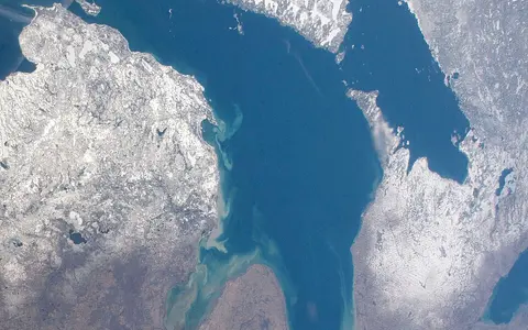

Where the Lake Huron name applies
This record covers Lake Huron from the Straits of Mackinac and lower St. Marys River in the northwest to the head of the St. Clair River at Port Huron–Sarnia in the south. It includes Georgian Bay east of the Bruce Peninsula, the North Channel north of Manitoulin Island, Saginaw Bay in Michigan, and the main open basin. It does not redefine Lake Michigan, the upper St. Marys River, St. Clair River, Lake St. Clair, or the surrounding watershed as parts of the named lake.[2][6]
The Canadian Geographical Names Database classifies Lake Huron as an official lake and attaches the locating coordinate 44°56′39″ N, 82°13′22″ W (44.9440939, −82.2228182) at a stated relevance scale of 1:5,000,000. This is a map reference in the lake's eastern main basin, not a surveyed centroid, border point, or boundary definition. The international boundary crosses the lake between Ontario and Michigan; it does not divide the water into separate physical basins.[1]
What the standard measurements mean
The binational Great Lakes physical table gives Lake Huron a surface area of 59,600 km², volume of 3,540 km³, mean depth of 59 m, and maximum depth of 229 m. Volume and depths are measured at low water. Its conventional maximum length and breadth are 332 km and 245 km; because the source does not define endpoint or transect construction, these are orientation figures rather than survey-grade axes. The listed 6,157 km shoreline includes islands and is inherently dependent on map scale and island treatment.[3]
Navigation charts use 176.0 m (577.5 ft) on International Great Lakes Datum 1985 as Lake Huron's Low Water Datum. It is a reference plane for charted depth, not a fixed elevation of the moving surface. The same datum applies to Lake Michigan, consistent with their shared level through the Straits of Mackinac. The coordinated 229 m maximum depth therefore describes vertical distance below low water; it should not be combined with a current gauge reading as though both used today's surface.[5][6]
Ridges divide a multi-basin lake floor
NOAA's bathymetric compilation draws from U.S. and Canadian hydrographic soundings collected for at least 150 years. Its 5 m and 10 m contours show that the main lake is not one depression: the western floor contains the Thunder and Harrisville basins, the eastern floor the Goderich and Sarnia basins, and the north the Manitoulin, Cockburn, and Barrie basins. Ridges and knolls separate or constrict these lows, while Saginaw Bay occupies a much shallower western embayment.[4]
The Alpena–Amberley Ridge is the clearest cross-lake structure, extending from northeastern Michigan toward Point Clark in Ontario. The NOAA map also shows Thunder Ridge, Huron Ridge, Sarnia Ridge, the Tobermory Knolls, and the channels around the Bruce Peninsula. These names describe submerged relief; they are not administrative divisions. Manitoulin Island and the Bruce Peninsula partly screen the North Channel and Georgian Bay from the main basin, so exchange occurs through comparatively narrow, irregular passages rather than across an uninterrupted open front.[4]
Deep lows split by ridges
Western and eastern basins are organized around the submerged Alpena–Amberley and related ridges.
Shield shore and deep interior
The Bruce Peninsula bounds its west side; island-rich gneiss shores frame its north and east.
Broad shallow embayment
A long channel crosses the shallow bay floor toward the deeper open lake.
Old rock structure, glacial erosion, changing outlets
Continental ice repeatedly crossed the region during the Ice Age, abrading bedrock, exploiting weaker layers and fractures, and leaving till, sand, gravel, and lake sediment. The shore consequently changes character around the basin: glacial deposits dominate much of the south; Paleozoic limestone and dolostone underlie the Bruce Peninsula, Manitoulin and Drummond islands, and parts of northern Michigan; Precambrian Shield rock reaches the northern and eastern shores of Georgian Bay and the North Channel.[2][8]
Eastern Georgian Bay's island pattern is specifically bedrock-controlled. Alternating resistant and less-resistant bands of folded gneiss weather and erode into parallel ridges and valleys. Because the bedrock surface slopes gently beneath shallow water, ridge crests emerge as elongated islands and shoals while the valleys form narrow inlets. This process explains the coast more precisely than a generic claim that glaciers simply “made many islands.”[8]
Deglaciation did not produce the modern shoreline at once. Outlets shifted and the land rose unevenly as the crust rebounded after removal of the ice load. During a low-water phase roughly 9,900–7,500 years ago, the Alpena–Amberley Ridge stood above water as a corridor between Michigan and Ontario; NOAA-backed sonar surveys and dated submerged wood document a landscape later drowned by rising lake level. The present basin therefore contains former terrestrial surfaces as well as glacially excavated lows.[9]
Two upper connections, one principal outlet
Lake Superior descends about 6.4 m through the 125 km St. Marys River before entering northern Lake Huron. At the Straits of Mackinac, Lake Michigan and Lake Huron have the same long-term level and exchange water in both directions. NOAA observations and models show that straits currents reverse on average about every 1.5 days under wind forcing, even though the overall transport is from Michigan toward Huron. “Inflow from Lake Michigan” is therefore a net balance, not a steady one-way river.[2][7]
Direct precipitation, groundwater, and tributaries add water locally. Major direct drainage enters through the Saginaw River in Michigan and the Maitland, Saugeen, Ausable, and Nottawasaga rivers in Ontario; many smaller Shield streams enter Georgian Bay and the North Channel. The principal outlet begins at Port Huron–Sarnia as the St. Clair River, then continues through Lake St. Clair and the Detroit River to Lake Erie. The conventional 22-year retention time is lake volume divided by mean outflow, not the travel time of every water parcel.[2][3]
Drainage-area totals require special care. The coordinated table reports 134,100 km² of land drainage and explicitly includes the St. Marys River area, but not the entire upstream land basins of Lakes Superior and Michigan. The 2022–2026 LAMP prints smaller, mutually inconsistent watershed figures (64,497 km² in its facts panel and 59,590 km² in the later text) without reconciling their boundaries. This page therefore retains the defined coordinated figure and does not merge the alternatives.[2][3]
Stratification reorganizes circulation
Lake Huron undergoes an annual thermal cycle. Cooling and wind mixing leave the water column nearly uniform in temperature by late autumn. Spring and summer heating then creates stratification: warm, less-dense surface water overlies cold deep water, separated by a thermocline where temperature changes rapidly with depth. NOAA's synthesis describes a well-developed lakewide thermocline by August.[10]
Wind, rotation, temperature gradients, and basin relief organize the currents. NOAA reports a mean counterclockwise, or cyclonic, circulation in the main basin in both summer and winter, stronger in winter, and a persistent surface flow into Georgian Bay with compensating deeper return flow in the cited climatology. During the stratified season, short-period near-inertial currents rotate clockwise on about an 18-hour cycle. These are mean and recurring patterns, not a promise of current direction at a particular shore or hour.[10]
Depth and exposure produce contrasting winters
Environment and Climate Change Canada's 1991–2020 lake-ice normals place the median Lake Huron–Georgian Bay ice season from early December to late April. Median maximum cover is about 43% for Lake Huron in mid-February but about 85% for Georgian Bay in late February; maximum-season coverage varies widely, from roughly 25% to 98%. Shallow coastal water cools first, while the deep central lake more often remains open; ice can persist latest in the North Channel.[11]
Open water also modifies downwind weather. When cold air crosses relatively warm unfrozen water, it gains heat and moisture, rises, and can produce narrow lake-effect snow bands. Fetch—the distance air travels across open water—together with wind direction, air–water temperature contrast, shoreline orientation, and nearby relief controls where bands form and land. Expanding ice reduces the available open-water source, while storms redistribute ice into leads, compact fields, and pressure ridges.[11][12]
A moving surface acts on unlike coasts
Michigan–Huron levels respond over seasons and years to precipitation on the lakes, basin runoff, evaporation, St. Marys inflow, and St. Clair outflow. Wind and atmospheric-pressure changes add shorter local fluctuations. The outlet is not controlled by a lake-level regulation structure, so 176.0 m Low Water Datum must never be read as a maintained target elevation. Ice cover, water temperature, and wind alter evaporation as well as wave exposure.[5][13]
The geomorphic result differs by coast. Waves and high water erode unconsolidated till bluffs and beaches along the southern and western margins; transported sand can feed bars, dunes, and bay-mouth wetlands. Resistant carbonate headlands around the Bruce Peninsula and Manitoulin break into cliffs, shelves, and reefs, while the gneiss coast of eastern Georgian Bay forms rocky points, shoals, and narrow inlets. Postglacial rebound continues to tilt the basin, so a long-term level change relative to land is not spatially identical at the northern and southern shores.[2][8][13]
The middle reach of the Great Lakes–St. Lawrence system
In the principal drainage route, Lake Superior lies upstream of Lake Huron; Lake Erie and Lake Ontario lie downstream. Lake Michigan joins laterally through the Straits of Mackinac rather than through a descending river. The Lake Huron name therefore describes a geographic subdivision within one hydraulic Michigan–Huron water body, while the St. Clair outlet fixes its place in the eastward drainage chain.[6][7]
Compare the downstream Lake Erie, follow the larger sequence through Niagara Falls, or use the lake hub and terrain index to place Huron's basins, Shield islands, carbonate shelves, glacial deposits, and connecting channels within the wider atlas.
Sources and measurement notes
- Geographical Names Board of Canada, Lake Huron, Canadian Geographical Names Database key FBPQQ (decision date 18 February 1994; accessed 29 August 2026). Source for accepted English name, lake classification, locating coordinate, and 1:5,000,000 relevance scale. Environment and Climate Change Canada's catalogue records the companion French federal title using Lac Huron.[2]
- Environment and Climate Change Canada and U.S. Environmental Protection Agency, Lake Huron Lakewide Action and Management Plan, 2022–2026, En164-56/2023E-PDF, EPA 905-R-23-005 (2022; catalogue record; accessed 29 August 2026), especially pp. 7 and 20–26. Sources for federal English/French title usage, the four interacting lake divisions, physical facts, shore geology, water sources and outlets, St. Marys River drop and length, direct tributaries, and the two unreconciled watershed-area figures retained as an uncertainty.
- NOAA Great Lakes Environmental Research Laboratory, Great Lakes Physical Characteristics (accessed 29 August 2026). Coordinated length, breadth, area, low-water volume and depths, land-drainage area, island-inclusive shoreline, retention estimate, and outlet. The page identifies its source edition as the Government of Canada/U.S. EPA Great Lakes: An Environmental Atlas and Resource Book, 3rd ed. (1995).
- NOAA National Centers for Environmental Information, Bathymetry of Lake Huron and the full-resolution Bathymetry of Lake Huron with Topography (accessed 29 August 2026). The compilation combines historic U.S. and Canadian hydrographic data; the map uses 5 m and 10 m contours and supplies the named basin, ridge, knoll, and channel framework. It is not a navigation chart.
- NOAA Center for Operational Oceanographic Products and Services, Great Lakes Low Water Datums (accessed 29 August 2026). Source for the 176.0 m (577.5 ft) Lake Huron and Lake Michigan chart datum on IGLD 1985 and for the sloping datum surfaces in the connecting rivers.
- International Joint Commission, Chiasson, C. and Bunch, K., Building Resilience along Lake Michigan and Huron Shorelines (13 October 2020; accessed 29 August 2026). Source for treating separately named Michigan and Huron as one hydraulic lake through the Straits of Mackinac.
- NOAA Great Lakes Environmental Research Laboratory, Predicting Currents in the Straits of Mackinac (accessed 29 August 2026). Source for overall Michigan-to-Huron transport, wind-driven reversals about every 1.5 days, opposing surface and deep flows in summer, and the Lake Michigan–Huron model domain.
- Natural Resources Canada and Ontario Geological Survey, Turner, B., Quat, M., Debicki, R. and Thurston, P., Parry Sound: Canadian Shield and Glacier-Sculpted Gneiss in Cottage Country, GeoTours Northern Ontario series (2015; accessed 29 August 2026), especially pp. 3–5. Source for repeated glacial abrasion and the bedrock, relief, island, shoal, inlet, and sediment contrasts of eastern Georgian Bay.
- NOAA Office of National Marine Sanctuaries, Thunder Bay National Marine Sanctuary 2013 Condition Report: Response to Pressures and Site History and Resources (2013; accessed 29 August 2026). Sources for the Alpena–Amberley Ridge's exposed interval and endpoints, sonar mapping, dated submerged wood, postglacial inundation, and Thunder Bay floor materials and sinkhole development.
- Kelley, J. G. W., Zhang, A.-J., Chu, P. and Lang, G. A., Skill Assessment of NOS Lake Huron Operational Forecast System (LHOFS), NOAA Technical Memorandum NOS CS 23 (October 2010; accessed 29 August 2026), pp. 3–4. Source for the annual thermal cycle, August stratification, mean cyclonic circulation, Georgian Bay exchange pattern, wind and pressure effects on level, and near-inertial current period.
- Environment and Climate Change Canada, Canadian Ice Service, Lake Ice Climate Normals for the Great Lakes, 1991 to 2020 (accessed 29 August 2026). Source for measurement-method cautions, Lake Huron–Georgian Bay median ice season, timing and percentage of median maximum cover, 25–98% variability, late North Channel ice, and depth, wind, and storm controls.
- National Weather Service Gaylord, Smith, B. B., Science: Lake Effect Snow (accessed 29 August 2026). Source for the cold-air-over-open-water mechanism and the roles of fetch, wind direction, instability, moisture, elevation, and shoreline orientation.
- International Joint Commission, Controlling Water Levels on Lake Michigan–Huron Is a Tricky Business (17 October 2013; accessed 29 August 2026). Source for seasonal and longer-term water-balance controls, lack of outlet regulation, evaporation controls, short-term wind and storm effects, and ongoing basin tilt from glacial isostatic adjustment.