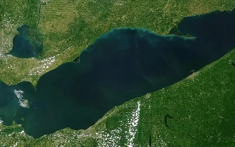

The lake, not the whole drainage network
This record covers the physical water body called Lake Erie, from the Detroit River entrance in the west to the head of the Niagara River between Fort Erie and Buffalo in the east. It does not treat the St. Clair River, Lake St. Clair, Detroit River, upper Niagara River, or the surrounding watershed as parts of the lake itself. Those connected waters may be grouped with Erie in management programs, but they remain distinct geographic features. The Canadian Geographical Names Database classifies Lake Erie as a lake polygon and recognizes both Lake Erie and Lac Érié as official forms.[1][4]
A useful map reference is 42°19′36″ N, 81°10′36″ W (42.3265975, −81.176531), the coordinate attached to the official Canadian polygon at a stated relevance scale of 1:5,000,000. It is a locating point, not a surveyed centroid or a definition of the international boundary. The political border crosses the water: Ontario occupies the north side, while Michigan reaches the western shore and Ohio, Pennsylvania, and New York line the south and east.[1]
What the headline measurements describe
The U.S. Environmental Protection Agency's coordinated Great Lakes table gives Lake Erie a water area of 25,700 km² (9,910 mi²), volume of 484 km³ (116 mi³), mean depth of 19 m (62 ft), and maximum depth of 64 m (210 ft). Depth and volume are explicitly referenced to low water. The same table gives 1,402 km (871 mi) of shoreline including islands; that conventional figure depends on mapping scale and island treatment and should not be read as a uniquely exact coastline length.[2]
Navigation depths use a Low Water Datum of 173.5 m (569.2 ft) on International Great Lakes Datum 1985. This is a chart reference plane, not a claim that the moving lake surface remains at 173.5 m. Actual levels vary over hours, seasons, and multi-year wet and dry periods. Stating the datum prevents a common error: combining a depth measured from chart low water with a current or long-term-average surface elevation as though both described the same water surface.[6][8]
Three basins deepen from west to east
Lake Erie is not a uniformly shallow bowl. EPA divides it into western, central, and eastern basins. The western basin, roughly one-fifth of the lake, averages 7.4 m and includes a 19 m maximum in the deep natural channels of the island area. Most of the western basin floor is much shallower: NOAA's mapped basin surface extends mainly to about 10–11 m. The central basin is broad and comparatively even, averaging 18.3 m and reaching about 25 m. The eastern basin averages about 24 m and contains the lake maximum—63 m in NOAA's one-metre-contour compilation and 64 m after EPA rounding.[3][5]
Submerged ridges help organize that eastward progression. The Pelee–Lorain Ridge runs southeast from Pelee Island toward Ohio near the western–central transition. Farther east, the broad Long Point–Erie Ridge reaches from the Long Point area almost to Presque Isle and separates much of the central floor from the deeper eastern bowl. NOAA interprets both as glacial moraines—ridges of debris deposited or reshaped at an ice margin—while noting uncertainty in parts of their detailed evolution.[5]
7.4 m average
Island-studded and mostly about 10–11 m or less, with deeper scoured channels among reefs and islands.
18.3 m average · 25 m maximum
A broad, nearly level floor where a thin cold bottom layer can form during summer stratification.
24 m average · 63–64 m maximum
The deepest bowl, beyond the Long Point–Erie Ridge and immediately upstream of the Niagara outlet.
Bedrock valleys enlarged by ice
The basin began with layered Paleozoic sedimentary rocks, especially marine shale, limestone, and dolostone. Rivers cut valleys into those rocks before the Ice Age. Repeated Pleistocene ice advances then widened and deepened the lowland, exploiting weaker strata and modifying the older drainage. NOAA's synthesis places final ice retreat from the area at about 13,000 years before present; that is the age of deglaciation used in the source, not the age of the rocks or of today's exact shoreline. Glacial till and lake sediment later smoothed much of the floor, while moraines preserved or created some basin divides.[5]
The western islands reveal the bedrock control particularly well. The Bass Islands, Catawba Island, and the Sister Islands are erosional remnants of resistant Silurian dolostone; Marblehead, Kelleys Island, and Pelee Island stand on resistant Devonian limestone. Currents cut deeper passages through the carbonate rock between islands. In the eastern basin, resistant limestone ridges contrast with softer shale and siltstone along parts of the southern shore.[5]
Bluffs supply the spits
Low glacial lake plains and till bluffs dominate much of the margin, but the shore is not interchangeable around the lake. Maumee and Sandusky bays indent the shallow west; the island and reef zone lies between Point Pelee and the Marblehead–Bass Islands area; the straighter central south shore carries eroding bluffs and river mouths; and the eastern basin is framed by Long Point on the north and Presque Isle on the south. Nearshore slopes usually deepen abruptly within 1–3 km of land, then flatten across the basin floor.[5]
Waves erode unconsolidated shore cliffs, currents move the released sand alongshore, and convergence zones build spits and bars. Long Point Spit extends about 35 km east-southeast from Ontario and is a late-Holocene to modern deposit built largely from sand carried east from eroding cliffs. Presque Isle is a recurved spit at another longshore-drift convergence. These are active sediment-routing features, not fixed bedrock peninsulas; storms, changing water level, ice, dredging, and shore protection can all alter the local balance of erosion and deposition.[5]
Upper-lake water in, Niagara water out
Water from the upper Great Lakes descends from Lake Huron through the St. Clair River, Lake St. Clair, and Detroit River. The 2019–2023 binational Lake Erie plan estimates that this connected system supplies about 80% of average total inflow. Direct precipitation and local tributaries supply the balance; named direct rivers include the Maumee, Sandusky, Cuyahoga, Raisin, Huron, and Grand. The natural main outlet is the Niagara River, which begins between Buffalo and Fort Erie, descends through Niagara Falls, and enters Lake Ontario.[3][4]
EPA's 2.6-year retention time is a hydraulic estimate based on lake volume and mean outflow, not the measured travel time of every parcel of water. The joint plan gives the same average and uses it to show that water moves through Erie much faster than through the deeper upper lakes. Its watershed figure—78,062 km² (30,140 mi²)—combines the Lake Erie and St. Clair–Detroit system drainage areas. It does not include the entire upstream land area draining into Lakes Superior, Michigan, and Huron, even though their water ultimately passes through Erie.[2][4]
Stratification, ice, and rapid response
In warm months, the central and eastern basins commonly stratify: a warm, less dense surface layer (the epilimnion) overlies colder, denser bottom water (the hypolimnion). The shallow, wind-exposed western basin may stratify briefly but mixes more readily. Erie also gains and loses heat faster than the deeper Great Lakes. Ice therefore develops readily in cold winters, beginning in shallow water, but coverage is not a fixed lake characteristic. NOAA's standardized ice archive runs from 1973 to the present and shows strong year-to-year variation in timing and extent.[3][7]
Open water modifies weather on adjacent land. When cold air crosses the warmer lake, it acquires heat and moisture; rising and cooling air can then form narrow lake-effect snow bands. Wind direction controls where those bands land, while a longer fetch—the distance air travels over water—usually increases moisture uptake. Around eastern Erie, prevailing winter flow often places the heavier bands south and southeast of Buffalo, and extensive ice reduces the open-water moisture source.[9]
Wind setup is not a tide
Lake level changes operate on several time scales. Basin-wide storage responds over seasons and years to precipitation, runoff, evaporation, inflow, and outflow. Over hours, strong wind and atmospheric- pressure gradients can tilt the long east–west surface. That temporary tilt is wind setup. When forcing relaxes, water can rebound and oscillate as a seiche, a standing wave in the enclosed basin. Astronomical Great Lakes tides are less than 5 cm and are normally obscured by these larger meteorological changes.[8]
The long, shallow shape makes the western and eastern ends especially sensitive. Under extreme wind setup, the National Weather Service reports that simultaneous levels at Toledo and Buffalo can differ by more than 10 ft (3.0 m), with high water at one end and low water at the other. This is a short-lived surface slope rather than a 3 m change in the lake's total volume. Reversing wind can reverse which shore floods, and the returning flow also drives bottom currents through the eastern basin's Pennsylvania Channel.[5][8]
A lower link in the Great Lakes–St. Lawrence system
In the principal Great Lakes outflow route, Lake Erie lies downstream of Lake Huron and upstream of Lake Ontario. From Erie's Niagara outlet, water passes to Lake Ontario and then the St. Lawrence River and Atlantic Ocean. The large elevation step between Erie and Ontario creates the Niagara corridor and falls, while Erie's own surface remains a low-gradient standing-water basin.
Compare the upstream Lake Huron and downstream Lake Ontario, follow the outlet at Niagara Falls, or use the lake hub and terrain index to place Erie's basin, moraines, islands, and shoreforms within the wider atlas.
Sources and measurement notes
- Geographical Names Board of Canada, Lac Érié / Lake Erie combined polygon record and Lake Erie, Canadian Geographical Names Database key FEHRJ (decision date 18 February 1994; records modified 16 February 2021; accessed 29 August 2026). Sources for feature type, official English and French forms, coordinate, mapping scale, and coordinate limitations.
- U.S. Environmental Protection Agency, Physical Features of the Great Lakes (accessed 29 August 2026). Coordinated area, low-water depth and volume, shoreline, land-drainage, and retention-time figures. The page identifies its principal physical dataset as the Coordinating Committee on Great Lakes Basic Hydraulic and Hydrologic Data, 1977, and separately documents variation among published volume estimates.
- U.S. Environmental Protection Agency, Lake Erie (updated 11 May 2026; accessed 29 August 2026). Source for three-basin average and maximum depths, the western basin's approximate area share, seasonal stratification, 80% Detroit River inflow share, and the definition of the 2.6-year retention estimate.
- Environment and Climate Change Canada and U.S. Environmental Protection Agency, Lake Erie Lakewide Action and Management Plan, 2019–2023 (2021; accessed 29 August 2026), especially pp. 1 and 7–8. Source for management-scope distinctions, the Lake Huron–St. Clair–Detroit connection, average inflow share, major tributaries, Niagara outflow, retention time, and the combined 78,062 km² Lake Erie and St. Clair–Detroit watershed area.
- Holcombe, T. L., Taylor, L. A., Warren, J. S., Vincent, P. A., Reid, D. F. and Herdendorf, C. E., Lake-Floor Geomorphology of Lake Erie, NOAA National Geophysical Data Center Research Publication RP-3 (January 2005), with the companion Lake Erie and Lake Saint Clair Geomorphology dataset documentation (accessed 29 August 2026). The one-metre contours compile U.S. and Canadian hydrographic soundings collected since 1903. Sources for bedrock and glacial history, basin depths, islands, submerged ridges, nearshore slope, Long Point and Presque Isle sediment transport, and wind-driven eastern-basin return flow. Some landform origins are explicitly interpretations, not settled measurements.
- U.S. Army Corps of Engineers, Coastal Geology, Engineer Manual EM 1110-2-1810 (31 January 1995), table 2-3. Source for Lake Erie's 173.5 m Low Water Datum on IGLD 1985; this is a navigation-chart reference plane rather than a current lake-level observation.
- NOAA Great Lakes Environmental Research Laboratory, Great Lakes Ice Cover (accessed 29 August 2026). Source for the standardized 1973–present satellite-and-chart archive, daily surface products, interannual variability, and the role of ice in water movement and thermal structure.
- NOAA National Ocean Service, Do the Great Lakes have tides? and What is a seiche? (both updated 16 June 2024), together with National Weather Service Cleveland, Lake Erie High Water Level (accessed 29 August 2026). Sources for distinguishing tides, wind setup, and standing-wave seiches, and for the qualified extreme Toledo–Buffalo level difference.
- NOAA National Environmental Satellite, Data, and Information Service, What Is Lake Effect Snow? (26 August 2025), and National Weather Service Buffalo, Buffalo Climate Narrative (accessed 29 August 2026). Sources for the lake-effect mechanism, fetch and wind-direction controls, eastern Lake Erie snowbelt orientation, and the suppressing effect of extensive ice on the open-water moisture supply.