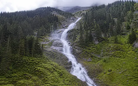
What Krimml Waterfalls are
Krimml Waterfalls lie beside the village of Krimml in Salzburg's Pinzgau region, near the western end of the Hohe Tauern. The Krimmler Ache approaches from the south through a broad high mountain valley, then crosses an abrupt, roughly 400-metre break in terrain before reaching the basin around Krimml.
The waterfall is a connected sequence rather than one uninterrupted free fall. Its three principal stages are known as the upper, middle, and lower falls. The upper and lower drops are each around 140 metres high, while the middle stage is about 100 metres; differing measurement points and rounded tier figures account for variation among published totals. The accepted combined descent is approximately 380 metres.
A stepped outlet from the Krimmler Achental
The Krimmler Achental is a north-draining trough valley that reaches deep into the Central Eastern Alps. Its relatively broad floor and steep sidewalls record prolonged erosion by valley glaciers. At its northern end, however, the valley floor remains high above the Upper Salzach corridor, producing the large local contrast in elevation crossed by the falls.
This is a classic tributary-to-main-valley relationship. During repeated Quaternary glaciations, the larger ice system occupying the Salzach valley excavated and lowered its trough more strongly than ice within the tributary valley. The Krimmler Ache was left entering across a steep hanging or stepped valley mouth. Later river erosion divided that descent into the three major waterfall stages visible today.
High glacial trough
The Krimmler Ache gathers in a broad Alpine valley before reaching the break in slope.
Three resistant steps
Hard rock and inherited relief organize the river into upper, middle, and lower falls.
Krimml basin
The river regathers below the lower fall and continues toward the Salzach.
Crystalline rock at the Tauern Window margin
The falls occupy the western Hohe Tauern near the margin of the Tauern Window, a major Alpine structure where erosion exposes deeply buried metamorphic and crystalline rocks beneath surrounding nappes. Resistant rocks at the valley step have helped preserve a steep descent instead of weathering into a continuous gentle slope.
Rock strength alone does not produce the whole form. Joints, fractures, and differences within the bedrock guide individual channels and allow blocks to loosen under frost weathering and water pressure. Each main fall enters a turbulent receiving reach, where spray, entrained debris, and repeated high flows continue to rework the base and edges of the rock steps.
A glacier-influenced Alpine flow regime
The Krimmler Ache drains a catchment of about 110.7 square kilometres. Its headwaters rise among high peaks and glaciers near the main Alpine divide, including the Krimmler Kees. Snowfall stores water through winter, while spring thaw, summer snowmelt, glacier melt, and rainfall release it into the river.
This produces pronounced variation at several timescales. Discharge is lowest during the cold winter period, increases through the melt season, and is generally greatest in late June and July. Official reference material gives a mean flow of about 5.6 cubic metres per second, but high flows can be many times larger. On warm summer days, meltwater generated high in the basin takes hours to reach the falls, so the daily discharge maximum may occur late in the evening.
Glacier retreat is changing the balance of this water supply. Melt from exposed ice can temporarily support summer flow, but a smaller ice reservoir ultimately reduces long-term glacial storage. The falls will remain connected to snowfall, rain, and seasonal thaw even as the relative contribution from glacier melt changes.
Snow storage, summer melt, and mountain rainfall
The western Hohe Tauern lie in an inner-Alpine setting but still receive substantial precipitation as moist air is lifted across surrounding ranges. Elevation strongly controls whether that precipitation falls as rain or snow. Long periods of winter snow cover delay runoff, while warming in late spring and summer activates streams across the high basin.
Summer rainfall can add short, rapid pulses to the broader melt-season rise. Cold spells suppress snow and ice melt; warm clear weather strengthens it. The result is a waterfall whose width, spray, and division among rock channels respond to both basin-wide seasons and day-to-day mountain weather.
From the Alpine divide to the Danube basin
After the lower fall, the Krimmler Ache flows north and joins the young Salzach near Vorderkrimml. The Salzach continues east through the Pinzgau, then turns north to join the Inn. The Inn enters the Danube, carrying water from the Krimmler catchment onward toward the Black Sea.
The head of the Krimmler Achental lies close to the main Alpine watershed and the border with Italy, yet the falls belong to the north-draining Danube system. This position links very local glacial landforms to a continental-scale river network. Compare their hanging-valley relief with Mardalsfossen, or continue through the waterfalls hub, rivers hub, and mountains hub.