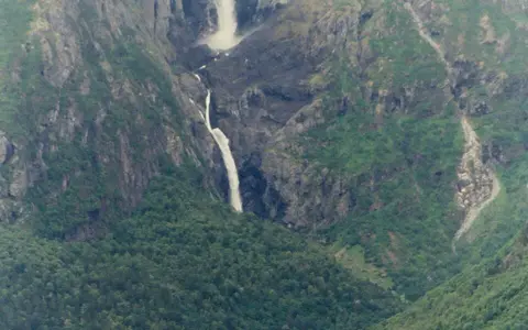
Eikesdalen mountain setting
Mardalsfossen lies near the southern end of Eikesdalsvatnet in Molde municipality, Møre og Romsdal. The waterfall occupies the western side of Eikesdalen, an inner-fjord valley enclosed by mountains that rise sharply from the lake and valley floor. This large contrast in elevation provides the basic framework for the fall.
The landform belongs to a terrain strongly modified by Quaternary glaciation. Ice deepened the principal valley more effectively than the smaller tributary basin above it, leaving the Mardøla perched at high elevation beside the trough. The river crosses this abrupt break in relief as a long waterfall sequence rather than descending along a gently graded tributary channel.
Drop, rock, and waterfall form
The commonly reported total descent is about 705 metres. Within that descent, the highest near-vertical fall is about 297 metres; below it, water continues over steep rock and broken lower drops toward Mardalen. The name Mardalsfossen can refer to this connected fall sequence, while the principal southern fall is also known as Søre Mardalsfossen.
The surrounding bedrock is dominated regionally by old crystalline rocks, especially gneiss affected by Caledonian deformation. Resistant rock supports the steep valley wall, while joints, fractures, and variations in weathering help guide water across the face. At high discharge, part of the falling stream breaks into spray before reaching the lower slope, a consequence of the long open drop and exposure to wind.
Mountain runoff and regulated flow
The natural catchment gathers rain and snow across high ground above the falls. Western Norway's maritime climate brings frequent moisture from the North Atlantic; uplift over the mountains enhances precipitation, while winter snow stores part of the water until thaw. Natural discharge would therefore rise with snowmelt and wet weather and decline during cold or dry periods.
Flow at Mardalsfossen is now strongly regulated. Water from the Mardøla system was diverted for the Grytten hydroelectric development in the 1970s, reducing the catchment that supplies the falls naturally. Required releases maintain a visible summer flow during specified periods, but outside that season discharge may be very low. The modern waterfall thus reflects both mountain hydrology and an engineered transfer of water between drainage systems.
About 705 m
The river loses elevation through a tall upper fall and a broken lower sequence.
About 297 m
The principal near-vertical drop forms the most distinct part of the falls.
Regulated mountain runoff
Rain, snowmelt, diversion, and scheduled releases govern modern discharge.
From upland basin to the fjord system
Mardøla water that remains in the natural channel descends through Mardalsfossen, continues along the valley floor, and enters Eikesdalsvatnet. The lake drains northward through the Eira toward Eresfjorden, linking the waterfall to the Norwegian Sea by way of an inner-fjord river system. Mardalsfossen is therefore a tributary-valley feature nested within a much larger mountain-to-coast drainage network.
Its geography shows how several scales of relief connect: an upland gathering basin feeds a perched tributary, the tributary crosses a glacial valley wall, and the lower river joins a deep lake occupying the main trough. Regulation changes the amount and timing of water passing through that sequence, but the waterfall's position remains controlled by the inherited glacial topography and resistant mountain bedrock.