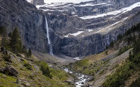
What Gavarnie Falls is
Gavarnie Falls, also known as the Grande Cascade de Gavarnie, lies in the Hautes-Pyrénées department of southern France, close to the main crest separating France and Spain. It occupies the eastern side of the Cirque de Gavarnie within Pyrenees National Park. Peaks around the Marboré massif rise above the cirque, while the valley opens north toward the settlement of Gavarnie-Gèdre.
The waterfall has a reported total descent of about 422 metres, with some official descriptions rounding the figure to 423 metres. It is not isolated from the surrounding landform: numerous smaller streams descend the cirque's rock tiers, but the Grande Cascade carries the principal concentrated flow from the high Marboré side. The falls form an early reach of the Gave de Gavarnie, the upper local name of the Gave de Pau.
A waterfall within a three-tiered mountain amphitheatre
The Cirque de Gavarnie is a broad, north-facing hollow enclosed by semicircular cliffs and summits above 3,000 metres. Its wall rises in three main tiers, producing roughly 1,600 metres of relief between the lower cirque and the highest crest. Gavarnie Falls occupies one steep line within this much larger stepped profile.
Water reaches the brink across an upper bench, accelerates over the edge, and descends through open air and against parts of the irregular rock face. Wind often separates the falling column into spray before it reaches the base. The water then regathers with runoff from neighbouring gullies on the boulder- and debris-covered cirque floor.
High snow and rock basin
Small headwater channels gather water around the Marboré crest and upper limestone benches.
Stepped cirque wall
The principal stream crosses a sharp break in slope within the tiered cliff system.
Debris-covered cirque floor
Falling water regroups among talus, rockfall blocks, and channels leading north into the valley.
Glacial enlargement of an older structural hollow
The cirque developed from the interaction of geological structure, river erosion, frost action, and repeated Quaternary glaciation. Mountain ice accumulated below the high crest and moved northward, quarrying fractured rock and enlarging the hollow. The main valley glacier deepened the outlet corridor while ice and snow in the cirque worked against the headwall and benches.
When the glaciers diminished, the large contrast in height between upper drainage surfaces and the cirque floor remained. Present streams now cross this inherited relief as waterfalls and cascades. Frost weathering, snow avalanches, rockfall, and runoff continue to move debris from the headwall, so the visible cliff and receiving slopes are active parts of the landform rather than a fixed glacial remnant.
Layered limestone and the Gavarnie thrust sheet
The wider Pyrénées–Mont Perdu massif is dominated by carbonate rock, especially thick limestone sequences that form high walls, ledges, caves, and sharply incised canyons. Around Gavarnie, these strata were folded, faulted, and carried along large thrust surfaces during formation of the Pyrenees. The area is a classic exposure of the Gavarnie thrust sheet, where older rock packages were displaced over younger units.
This structure helps explain the cirque's architectural appearance. Bedding surfaces and differences in rock resistance produce major benches, while fractures give water and frost access to the cliff. Some runoff moves across the surface, and some can pass through joints and solution openings in the limestone before re-emerging. The waterfall therefore reflects both the large-scale arrangement of the rock mass and the smaller pathways within it.
Snowmelt, high-elevation storage, and seasonal flow
The falls drain a compact high-mountain source area around Marboré. Pyrenees National Park material links the headwaters to the Lac de Marboré area near the crest, while snowfields, small ice bodies, direct precipitation, and meltwater all contribute to the upper channels. Fractured and soluble limestone can route part of this water below the surface before it reaches the waterfall lip.
Flow changes strongly through the year. Winter cold stores precipitation as snow and can build ice along the fall and wet cliff. Discharge generally increases as rising spring and summer temperatures melt the high snowpack, while rainfall can add shorter pulses. In dry or cold intervals the column narrows and wind dispersal becomes more conspicuous; during stronger flow, more water reaches the cirque floor as a coherent fall.
Below the cascade, the stream becomes part of the Gave de Gavarnie or upper Gave de Pau. Tributaries join it as it descends through the Luz–Gavarnie valley. The river later crosses lower Pyrenean valleys and the Aquitaine foreland before entering the Adour as a left-bank tributary.
A humid northern slope beside a drier southern flank
Gavarnie lies on the northern side of the central Pyrenean crest, where Atlantic moisture is lifted over high terrain. Orographic cooling supports substantial precipitation, and elevation determines how much arrives and remains as snow. Shaded high slopes and north-facing hollows preserve snow longer than exposed lower ground.
The main crest also marks a sharp regional contrast. UNESCO describes the French northern slope of the Pyrénées–Mont Perdu massif as humid and maritime-influenced, while the Spanish southern side is drier and more Mediterranean. Gavarnie Falls sits close to this divide but drains north, so its water balance is tied most directly to the cooler, wetter side of the range. Year-to-year differences in snowfall, melt timing, summer warmth, and rain alter both seasonal discharge and the duration of snow and ice storage.
From the Pyrenean crest to the Atlantic basin
Gavarnie Falls occupies a continental headwater position. The cirque stands immediately north of the France–Spain watershed, yet the waterfall's flow moves away from the crest through the Gave de Pau. That river joins the Adour, which reaches the Bay of Biscay on the Atlantic margin of southwestern France.
The landform also links contrasting terrain on either side of the Mont Perdu massif: glacial cirques face north into France, while deep limestone canyons cut the drier Spanish slope. Within Geography Atlas, continue to the Pyrenees for the range-scale setting, compare high-mountain flow and inherited glacial relief at Krimml Waterfalls, or browse the waterfalls hub, rivers hub, and mountains hub.