Western Thailand hill setting
The falls lie in Erawan National Park in Kanchanaburi Province, within the broken upland terrain west of the Khwae Yai valley. Ridges, short valleys, and carbonate hills divide the area into compact headwater catchments. Erawan occupies one of these steep local drainages rather than the channel of a large trunk river.
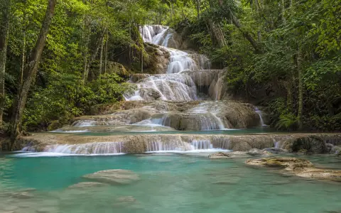
Across the waterfall reach, the stream loses elevation in repeated steps. The seven named tiers extend along roughly 1.5 kilometres of channel, but that distance is the length of the cascade sequence, not a single vertical drop. Some tiers form low, broad spillways; others cross steeper rock faces before entering pools at their bases.
Limestone ledges and pool-forming barriers
Limestone controls the characteristic stepped form. Water follows joints, bedding surfaces, and small differences in rock resistance, spreading over some ledges and concentrating into narrow threads at others. Erosion at the foot of each drop deepens hollows, while blocks, irregular bedrock, and carbonate deposits help impound the intervening pools.
Rain and soil water can dissolve calcium carbonate while moving through fractured limestone. Where the stream emerges, becomes turbulent, and loses carbon dioxide, some of that mineral load can precipitate again on rock and other wet surfaces. This process contributes to pale, uneven rims and pool margins, although floods, sediment, and falling debris can cut or redirect them.
Huai Mong Lai and seasonal flow
Huai Mong Lai gathers water from the surrounding hills and supplies the waterfall sequence. Its discharge responds to the tropical monsoon cycle. Rain during the wetter months raises runoff, connects more flow paths across the ledges, and increases turbulence and sediment movement through the pools.
The park lies partly in the rain shadow of higher terrain to the west, so its rainfall is lower than on some windward slopes in the region. Even so, the wet-season pulse is the main climatic control on the falls. During the drier months, flow contracts toward persistent channels, more rock surface becomes exposed, and water residence time in the pools increases.
Seven-tier cascade
Repeated limestone steps divide the stream into falls, chutes, and pools.
About 1.5 km
The reported distance describes the tiered channel sequence, not its vertical height.
Huai Mong Lai
A compact hill catchment feeds the falls and responds to monsoon rainfall.
Pool colour and changing water conditions
The blue-green appearance often associated with the pools is variable rather than a fixed colour of the stream. Clear water, pool depth, sunlight, pale carbonate surfaces, and fine suspended mineral particles all affect how light is absorbed and scattered. After heavy rain, greater discharge and sediment can make the water darker or cloudier.
The pool-and-step pattern also changes over longer periods. Carbonate deposition can build thin crusts and rims, while high flows erode loose material and open new spillways. Erawan is therefore a connected, evolving cascade reach whose form reflects both resistant limestone and the continuing work of flowing water.
Khwae Yai basin connection
Below the lowest tier, the stream leaves the confined cascade reach and continues toward the Khwae Yai side of Kanchanaburi's drainage network. The Khwae Yai joins the Khwae Noi at Kanchanaburi to form the Mae Klong, which then crosses Thailand's central lowland and reaches the Gulf of Thailand.
This downstream connection places Erawan within a much larger basin sequence: monsoon rain falls on western uplands, runoff is concentrated in Huai Mong Lai, limestone steps interrupt the channel, and the outflow ultimately enters a major lowland river system. The waterfall is a local gradient break nested within that regional transfer of water and sediment.