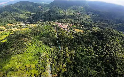
Northern Laos upland setting
The falls lie about 29 kilometres south of Luang Prabang, within the rugged hills that flank the Mekong valley. Northern Laos is strongly dissected: short streams drain forested ridges and confined valleys before joining larger lowland channels. Kuang Si occupies one of these compact upland catchments, with the waterfall complex marking a sharp local loss of elevation between the hill slopes and the lower valley floor.
Rather than forming a single isolated brink, Kuang Si extends through several levels. The upper stream reaches a steep main drop commonly reported at about 60 metres, then continues across lower ledges, shallow steps, and broad pools. This arrangement makes the site a cascade system: one prominent fall is connected to many smaller gradient breaks along the same watercourse.
Limestone, carbonate deposition, and terraces
Kuang Si flows through limestone terrain. Rain and soil water acquire carbon dioxide and become weakly acidic, allowing them to dissolve calcium carbonate while moving through rock fractures and the shallow subsurface. When the mineral-rich water re-emerges, becomes turbulent, or loses carbon dioxide at a cascade, some carbonate can precipitate again.
This deposition helps build pale rims and irregular ledges around the lower pools. Such deposits are commonly called tufa or travertine; at an active stream they can encrust rock, sediment, roots, and fallen wood. The resulting barriers split the flow, hold back pools, and redirect small channels. They are not permanent masonry-like steps: floodwater, falling debris, erosion, and renewed mineral growth can alter their shape.
Stream flow and monsoon control
The catchment has a tropical monsoon climate with a pronounced wet and dry seasonal cycle. Rainfall delivered during the warmer monsoon months raises runoff, broadens the falling water, and increases turbulence through the lower cascades. Higher flows can also carry fine sediment and organic debris into the pools. During the drier part of the year, less surface runoff reaches the channel and the cascade pattern becomes more clearly divided among the limestone steps.
Subsurface movement through fractures and carbonate rock can moderate the response between storms, but the waterfall remains tied to rainfall over a relatively small mountainous watershed. Its discharge therefore changes more quickly and seasonally than that of a waterfall supplied by a large lake or a major trunk river.
About 60 m
The principal fall descends from a steep limestone-backed slope.
Tiered cascade
Lower carbonate barriers divide the stream among pools and short drops.
Monsoon-fed catchment
Seasonal rainfall governs runoff through the upland stream system.
Pools, colour, and downstream connection
The lower pools occupy basins impounded by carbonate rims and natural channel obstructions. Their blue-green appearance is not a fixed property of the water. It varies with light, pool depth, suspended mineral particles, the pale carbonate bed, algae, and the amount of sediment carried by recent rain. Clearer low-flow conditions and a light-coloured floor can make shorter wavelengths of light especially conspicuous.
Water leaving the last cascades continues downslope through local drainage toward the Mekong corridor. Kuang Si is therefore a small-catchment landform nested within the much larger Mekong basin. Its physical geography links hillside rainfall, movement through limestone, carbonate deposition at the surface, erosion across a steep reach, and the transfer of water from northern Lao uplands toward the regional trunk river.