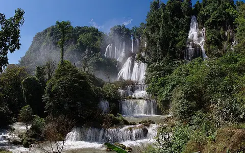
Western Thailand upland setting
The waterfall lies in Umphang Wildlife Sanctuary in Tak Province, close to Thailand's mountainous border region with Myanmar. This is rugged terrain of steep ridges, confined valleys, and short tributary streams. The falls occupy a sharp break in slope within that upland drainage network rather than the channel of a large lowland river.
Huai Klotho approaches the brink through a forested catchment and divides across an irregular cliff face. Separate threads descend ledges and steep chutes, reunite in places, and enter pools and channels below. The result is a waterfall complex with many adjacent drops, not a single narrow vertical plunge.
Limestone cliff and segmented form
Limestone provides the main rock framework. Fractures, bedding surfaces, and differences in resistance within the rock help steer water across the face and produce the stepped profile. Some sections project outward while others form recesses, allowing the stream to break into curtains, narrow falls, and shorter cascades.
Published dimensions vary: descriptions commonly place the overall descent in the approximate range of 200 to 300 metres and the wet cliff face at roughly 400 to 500 metres across during strong flow. These figures describe a wide multi-tier system and have not been established by a single consistent survey, so they are better treated as scale estimates than precise measurements.
Monsoon-fed flow
Thi Lo Su is a perennial waterfall, but its appearance is strongly seasonal. Moisture carried by the southwest monsoon supplies much of the catchment's annual rain. In the wet season, runoff from saturated slopes raises Huai Klotho, activates more channels across the cliff, and turns separated strands into a much broader sheet of falling water.
Intense storms can produce rapid rises, sediment-rich water, floating wood, and slope failures in the steep surrounding terrain. In the drier months, discharge contracts into the more persistent channels and exposes more of the ledged rock face. The waterfall therefore records both sustained upland drainage and the pronounced rainfall pulse of a tropical monsoon climate.
Broad segmented cascade
Many linked drops descend an irregular, multi-tier cliff.
Huai Klotho
A forested upland stream supplies the waterfall throughout the year.
About 200–300 m high
Published estimates vary; the active face can extend roughly 400–500 metres across.
Downstream drainage and regional connections
Below the falls, water continues through the deeply dissected Umphang highlands into the river network of western Thailand. These streams form part of the headwater country associated with the Mae Klong drainage, which carries water away from the border ranges toward Thailand's central lowlands and the Gulf of Thailand.
At the landform scale, Thi Lo Su links rainfall gathered over a compact mountain catchment with a resistant limestone step, a high-energy cascade reach, and lower tributary valleys. Its width reflects the way the stream spreads across the cliff during high discharge, while its tiered relief reflects the structure and uneven erosion of the rock beneath it.