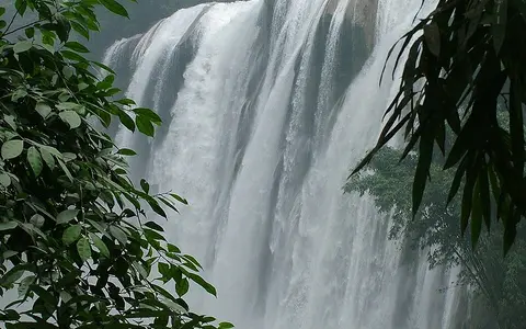
Guizhou Plateau setting
The waterfall lies near Zhenning in the Anshun region, within the dissected eastern part of the Yunnan–Guizhou Plateau. This is an elevated landscape of soluble carbonate rock, enclosed depressions, caves, residual hills, and river gorges. The Baishui River crosses the plateau surface before reaching an abrupt knickpoint—the sharp change in channel gradient that forms the falls.
Huangguoshu is the main drop in a wider sequence of waterfalls along the local river system. Its reported overall dimensions are about 77.8 metres high and 101 metres wide, although the visible breadth of falling water varies with discharge. The combination of a wide crest and substantial drop gives it the form of a cataract rather than a narrow single-thread plunge.
Karst structure and waterfall form
Carbonate bedrock is central to the landform. Slightly acidic water dissolves limestone along joints, bedding planes, and other weaknesses, while river abrasion and block removal enlarge the surface channel. At Huangguoshu, the river passes over a resistant rock lip into a recessed lower reach. A natural cave behind the falling sheet records the close connection between surface flow, rock dissolution, and underground voids in mature karst terrain.
The present edge is not fixed on a geological timescale. Turbulent water, entrained sediment, and repeated wetting attack the base and face of the drop. Undercutting and collapse remove support from the brink, allowing the waterfall to retreat upstream while extending the gorge below. Regional uplift and renewed river incision have helped preserve this strong contrast between the plateau channel and the lower valley.
River flow and monsoon controls
The Baishui River is supplied chiefly by rainfall over a humid subtropical catchment. The East Asian summer monsoon brings much of the annual precipitation during the warmer part of the year, so runoff and waterfall discharge are strongly seasonal. During wetter periods, flow occupies more of the broad rock face and turbulence intensifies in the plunge zone. In drier periods, the falling sheet contracts into narrower sections and more of the cliff becomes exposed.
Karst adds another control to this rainfall response. Water can move through fractures, caves, and underground pathways as well as along surface channels, giving the plateau a linked surface-and-subsurface drainage system. Even so, the main falls remain a surface knickpoint on the Baishui River, and their changing appearance primarily reflects the volume of water reaching the crest.
77.8 m
The river descends from the plateau channel into a lower karst gorge.
About 101 m
A broad brink carries a seasonally changing curtain of water.
Baishui River
Rain-fed flow links the waterfall to the wider Pearl River drainage system.
Gorge, spray, and downstream connection
Below the brink, falling water enters a confined receiving gorge. Impact and recirculating currents maintain the plunge zone, while spray keeps the adjacent rock surfaces persistently damp when discharge is high. The gorge carries water and eroded material away from the fall, connecting local cliff retreat to continued incision downstream.
The Baishui River feeds into the Dabang River system, which is part of the Pearl River basin. Huangguoshu therefore occupies a local gradient break within a much larger drainage network extending from the Guizhou Plateau toward southern China. Its physical geography joins several scales: monsoon rainfall over the headwater catchment, karst storage and channel flow, erosion at the brink, gorge development below, and eventual transfer of water into the Pearl River system.