,_Kakadu_National_Park,_Jim_Jim_Creek_--_2019_--_4248.jpg)
What Jim Jim Falls is
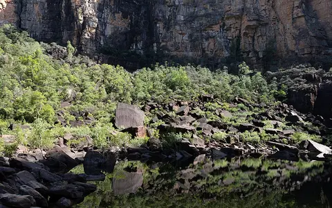
Jim Jim Falls stands on the western edge of the Arnhem Land Plateau in the southern part of Kakadu National Park. At the brink, Jim Jim Creek passes abruptly from gently inclined plateau drainage to a near-vertical descent of about 200 metres. The water lands in a large pool enclosed by high sandstone walls and block-strewn slopes.
The waterfall is not a large perennial-river cataract. It is a sharp break in a seasonal upland stream, and its scale comes chiefly from the relief of the escarpment. During high wet-season discharge the creek forms a powerful single fall; as runoff declines, the falling column narrows, fragments in wind and spray, and may disappear while water remains in pools along the creek and at the gorge foot.
Sandstone plateau, cliff, and gorge
The Arnhem Land Plateau is an extensive sandstone upland whose western margin rises roughly 200 to 300 metres above adjoining lowlands. Around Jim Jim Falls, the margin forms a high, recessed cliff rather than a gradual slope. Vertical faces, ledges, fractures, and fallen blocks record the long retreat of the plateau edge under weathering and erosion.
Jim Jim Creek exploits a notch in this resistant rim. At the base, falling water and sediment focus erosion in the plunge zone, while rockfalls enlarge the amphitheatre and supply the angular boulders that occupy the gorge floor. The broader landform reflects both stream erosion and slope failure: water removes weathered material, but gravity transfers much of the cliff debris to the foot of the escarpment.
Sandstone stone country
Shallow upland drainage gathers rainfall across rugged plateau surfaces.
Abrupt escarpment drop
The creek crosses the plateau margin at a high sandstone cliff.
Pool and boulder gorge
Plunge-zone erosion and rockfall shape the enclosed gorge floor.
Wet-season runoff and dry-season contraction
Jim Jim Creek responds to the tropical monsoon. Rain falling on the plateau during the wet season runs into shallow channels and converges at the escarpment, producing the waterfall's main annual flow. Intense storms can raise discharge quickly, while the progressive end of the rains reduces both the width and continuity of the fall.
The contrast between flow and stored water is important. Jim Jim Falls is seasonal rather than continuously flowing, yet pools can persist after surface flow across the brink has stopped. The gorge pool and residual creek pools therefore represent water retained within bedrock depressions and shaded reaches, not evidence of a steady year-round waterfall discharge.
A tropical wet–dry control
Kakadu has a monsoonal tropical climate with most rain concentrated from roughly November through March and very little during much of May through September. Moist northwesterly air, monsoon troughs, thunderstorms, and occasional tropical cyclones drive the wet-season pulse. The intervening dry months bring lower humidity, clearer skies, and strong water loss through evaporation.
This annual climate rhythm changes the waterfall more visibly than it changes the cliff. Wet-season flow connects the plateau creek, fall, plunge pool, and downstream channel as one active system. In the dry season that connection contracts into separated pools and short reaches, exposing the resistant rock and accumulated boulders that define the underlying landform.
From Arnhem Land stone country to northern floodplains
Below the falls, Jim Jim Creek leaves the narrow escarpment gorge and crosses lower savanna terrain. It belongs to the South Alligator River drainage, one of the large river systems that carry seasonal freshwater across Kakadu's lowlands and floodplains before reaching tidal reaches connected to Van Diemen Gulf.
Jim Jim Falls is therefore a boundary landform within a longer drainage sequence. It marks the transfer of runoff from elevated sandstone country to western lowlands, linking the waterfalls hub, the rivers hub, and the terrain index. Its physical geography is best understood at all three scales: a plunge at the cliff, a gorge at the plateau margin, and a seasonal creek within a north Australian river basin.