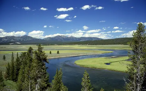

What Yellowstone Caldera is
Yellowstone Caldera occupies the northwestern corner of Wyoming and extends across the central part of Yellowstone National Park. It lies within a larger volcanic field that reaches into Montana and Idaho, but the youngest collapse structure is centered on the Yellowstone Plateau.
The caldera formed about 631,000 years ago during the eruption of the Lava Creek Tuff. Collapse created a basin tens of kilometres wide. Later rhyolite lava flows spread across parts of its floor, while uplift, faulting, glaciation, stream erosion, and sediment accumulation reshaped its margins. As a result, the rim is discontinuous and is less visually obvious than the walls of a small, steep-sided caldera.
Collapse basin, resurgent domes, and lava plateaus
The caldera is an elongated depression roughly 70 km from southwest to northeast and about 45 km across. Its floor is not uniformly low. Two broad areas, the Sour Creek and Mallard Lake resurgent domes, were lifted after collapse, and younger rhyolite flows filled or covered other parts of the basin.
Thick lava flows form rolling plateaus, steep flow fronts, and locally resistant uplands. Fault scarps, thermal basins, stream valleys, and lake shores provide more visible clues to the underlying structure than a continuous rim does. Beyond the youngest caldera, volcanic rocks and older collapse structures connect Yellowstone with the eastern Snake River Plain.
Broad caldera margin
A discontinuous structural rim surrounds a basin modified by later lava, ice, and rivers.
Resurgent domes
Post-collapse uplift raised broad sections of the caldera floor.
Rhyolite plateaus
Large lava flows bury parts of the original basin and create uneven uplands.
Lakes and rivers across a continental divide
Yellowstone Lake occupies part of the caldera's southeastern sector and adjacent terrain. The Yellowstone River enters from the south, passes through the lake, and then flows north out of the caldera before cutting the Grand Canyon of the Yellowstone. Its water ultimately joins the Missouri and Mississippi river system and reaches the Gulf of Mexico.
On the western side, the Firehole and Gibbon rivers drain thermal basins and volcanic plateaus before joining to form the Madison River. The Madison enters the Missouri system, while small headwaters southwest of the caldera cross the Continental Divide into the Snake and Columbia river network, which drains to the Pacific. Snowmelt, lakes, wetlands, and groundwater therefore connect the volcanic landform to drainage basins on both sides of the Rocky Mountains.
Elevation, snow, and a short cool season
The plateau's elevation produces long, cold winters and a brief mild summer. Snow supplies much of the annual water input, and spring melt raises rivers, saturates valley floors, and replenishes lakes and shallow groundwater. Higher ridges and mountain margins generally receive more precipitation than sheltered interior basins.
Topography also creates local temperature inversions in valleys and closed depressions. Cold air can settle over the plateau, while the large surface of Yellowstone Lake moderates nearby temperatures on a smaller scale. Seasonal freezing and thawing, runoff, and past glaciation all help shape soils, slopes, and stream channels across the volcanic surface.
Heat, groundwater, and surface landforms
Heat remaining beneath the volcanic field warms groundwater that circulates through fractures and porous volcanic rock. Where that water reaches the surface, it forms geyser basins, hot springs, fumaroles, and mud pots. These features are concentrated where heat supply, water, and pathways through the rock coincide.
Hydrothermal alteration changes strong volcanic rock into weaker clay-rich material, influencing local erosion and slope stability. Mineral deposits build terraces and sinter surfaces, while hot water enters nearby streams. The thermal features are therefore part of the plateau's hydrology and surface geology, not separate from its physical geography.
Rocky Mountains, hotspot track, and Snake River Plain
Yellowstone lies near the northeastern end of the Snake River Plain, a broad volcanic corridor across southern Idaho. Successively older volcanic centers occur to the southwest. This age pattern records the movement of the North American Plate over a long-lived source of magma commonly described as the Yellowstone hotspot.
The caldera sits where the hotspot-related volcanic plateau meets the structurally varied Rocky Mountains. Mountain ranges border the plateau, and the Continental Divide crosses its southern and western portions. Within the atlas, Yellowstone complements the lake-filled basin of Taal Volcano and the marine-flooded form of Santorini Caldera, while illustrating a much larger continental plateau setting.