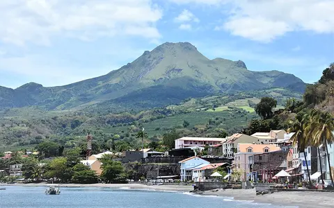

What Mount Pelée is
Mount Pelée occupies the north of Martinique, between the Caribbean Sea to the west and Atlantic-facing terrain to the east. Its high ground dominates a short, broad peninsula, and the former regional center of Saint-Pierre lies at the foot of its southwestern flank.
The mountain is a composite volcanic edifice rather than a simple, even-sided cone. Its upper slopes contain a crater, overlapping lava domes, and remnants of older constructional surfaces. Large flank failures have also left collapse scarps open toward the southwest, while younger material has rebuilt part of the edifice within them.
Domes, scarps, and layered slopes
Mount Pelée has grown through repeated eruptions of viscous lava and explosive release of fragmented material. Lava domes form when magma accumulates close to a vent instead of spreading into long, fluid flows. Dome collapse and explosive activity can send pyroclastic material into valleys, producing deposits that extend far below the summit.
Three major edifice failures since the late Pleistocene have cut broad scarps into the volcano. The modern cone developed within this inherited relief, so the mountain's form records both construction and removal: domes and deposits add new ground while collapse, runoff, and mass movement cut it back.
Étang Sec crater
The summit crater contains lava domes from the two most recent eruptive periods.
Pyroclastic aprons
Ash, blocks, and flow deposits mantle slopes that are now divided by steep ravines.
Southwest-facing scarps
Old sector collapses created open amphitheater-like terrain later occupied by younger volcanic growth.
Short rivers in steep volcanic valleys
Streams radiate outward from the summit region over short distances to the sea. Persistent tropical runoff has incised pyroclastic deposits into narrow, steep-walled ravines, making drainage lines some of the clearest features on the lower and middle slopes.
These channels also connect summit and flank processes to the coast. The Rivière du Prêcheur drains the western side, where landslide debris and loose volcanic sediment can be remobilized into mudflows. Elsewhere, channels carry water and sediment toward the Caribbean or Atlantic sides of northern Martinique, and their courses reflect ridges, old collapse topography, and the distribution of younger deposits.
Trade winds, height, and heavy rain
Martinique lies in the humid tropical belt and receives moisture mainly from the easterly trade winds. Air rising over Mount Pelée cools and condenses, increasing cloud and rainfall over the high ground and windward slopes. Conditions become cooler and generally wetter with elevation than on the nearby coast.
Frequent rain accelerates weathering, feeds radial streams, and strips loose sediment from steep slopes. It also supports dense vegetation across much of the volcano, although landslides, young deposits, exposed domes, and the highest wind- and cloud-affected terrain create breaks in that cover.
Northern Martinique in the volcanic arc
Mount Pelée is part of the Lesser Antilles volcanic arc, created above a subduction zone where Atlantic oceanic lithosphere descends beneath the Caribbean Plate. The arc forms a curved chain of volcanic islands along the eastern margin of the Caribbean Sea.
Within Martinique, Mount Pelée connects to older volcanic uplands farther south through the island's narrow central terrain. Within the volcanoes hub, it is a useful counterpart to Mount Merapi, another dome-forming stratovolcano whose ravines route pyroclastic sediment, and to Santorini Caldera, where collapse produced a much larger marine-flooded landform.