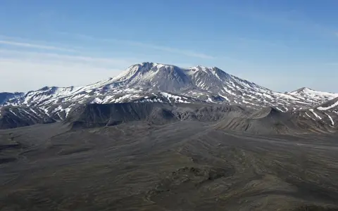
What Mount Katmai is
Mount Katmai stands in Katmai National Park and Preserve on the northern Alaska Peninsula, within the volcanic backbone of the Aleutian Range. The mountain lies roughly 10 kilometres east of Novarupta and north of the upper Katmai River drainage. Its western slopes face the high volcanic basin that contains Knife Creek and the Valley of Ten Thousand Smokes, while its eastern side descends toward the deeply indented Shelikof Strait coast.
The mountain is not a simple cone. Before 1912, repeated eruptions had built a large stratovolcano of lava flows, pyroclastic rock, and air-fall deposits. Collapse during the Novarupta eruption removed the summit and left a broad caldera enclosed by an uneven rim. Snowfields, glaciers, exposed lava stacks, collapse scarps, and the caldera lake now divide the edifice into several contrasting terrain zones.
A truncated cone above glacial valleys
Katmai's highest surviving rim reaches 2,047 metres, but the mountain's most prominent landform is the deep depression inside it. Steep inner walls fall toward the lake and expose thick sequences of volcanic rock. Large slump blocks interrupt parts of the wall, recording the structural failure that accompanied caldera formation.
Outside the caldera, the remains of the older cone descend through ice-cut troughs and sharp ridges. Several glaciers radiate from the mountain, and smaller glaciers occupy upper caldera-wall hollows. On the western side, Knife Creek Glaciers descend toward ash-covered low ground near the Valley of Ten Thousand Smokes. The contrast between the high rim, enclosed lake, ice-filled troughs, and lower volcanic basin gives Katmai much greater local complexity than an intact conical peak.
Irregular caldera rim
The 1912 collapse replaced the former summit with a broken crest around a deep central basin.
Lake and steep walls
A deep lake occupies much of the caldera floor beneath cliffs, talus, snowfields, and small glaciers.
Glacially cut flanks
Valley glaciers and meltwater channels dissect the layered volcanic edifice beyond the rim.
Collapse linked to the 1912 Novarupta eruption
Mount Katmai is built chiefly from lava flows, pyroclastic deposits, and layers of air-fall material resting on Late Jurassic sedimentary rocks of the Naknek Formation. It is one of several closely spaced volcanoes in the Katmai cluster, alongside Trident, Mageik, Martin, Griggs, and Novarupta. Their overlapping magma systems and eruptive products make the surrounding terrain a connected volcanic complex rather than a chain of isolated cones.
During the 1912 eruption, the main explosive vent opened at Novarupta, not at Mount Katmai. As a large volume of magma left storage beneath the cluster and moved toward the Novarupta vent, support beneath Katmai's summit was lost. The summit subsided to form a caldera more than 600 metres deep and with an estimated collapse volume of about 5.5 cubic kilometres. This lateral connection explains why the largest structural change occurred at a mountain separated from the principal vent.
Lava stacks, collapse debris, ash, and glacial sediment
The surviving caldera walls reveal the older construction of the volcano in cross-section. Resistant lava layers form ledges and ribs, while weaker fragmental deposits weather into recesses, gullies, and aprons of loose debris. Rockfalls and frost-shattered material continue to collect at the base of the inner walls and on steep outer slopes.
The 1912 eruption spread pumice and ash across the mountain and adjacent valleys. West of Katmai, thick pyroclastic-flow deposits filled pre-existing drainage around Knife Creek and created the Valley of Ten Thousand Smokes. Wind, snowmelt, and glacier flow have since redistributed this material. Some lower glacier surfaces remain mantled by thick ash and pumice, while streams cut pale, steep-sided channels through the deposit farther down valley.
An enclosed lake above radial meltwater drainage
Katmai's caldera contains a deep lake supplied by precipitation, snowmelt, glacier melt, and runoff from the inner walls. The lake has no perennial inlet streams; water reaches it through short seasonal channels, direct precipitation, and melting ice. Its surface lies well below the lowest parts of the rim, so the basin stores water within the collapsed summit rather than releasing it through an open river outlet.
Beyond the rim, drainage is radial but strongly reorganized by glaciers and the 1912 deposits. Meltwater and rain descend through short valleys on the outer flanks. Western drainage enters the Knife Creek system and the ash-filled basin around Novarupta, while eastern and southeastern slopes connect with headwaters flowing toward the Katmai River and Shelikof Strait. Glacial erosion supplies abundant fine sediment, and streams continue to rework both older volcanic rock and loose 1912 ash.
North Pacific storms across the Aleutian divide
Mount Katmai stands across a strong maritime climate boundary. Storms moving along the Aleutian chain and across the Gulf of Alaska bring frequent cloud, precipitation, and high winds. Moist Pacific air rises over the Aleutian Range, producing heavy rain and snow on high ground and on the Shelikof Strait side of the divide.
Elevation keeps the upper mountain cold enough to sustain glaciers and long-lasting snowfields. Wind redistributes snow across the exposed rim and into protected troughs, while repeated freezing and thawing break rock from the caldera walls. West of the crest, conditions grade toward the somewhat drier and more continental Bristol Bay side of the peninsula. Katmai's relief therefore influences both local precipitation and the direction in which snowmelt leaves the volcanic divide.
Aleutian Arc volcano between two drainage regions
Katmai belongs to the Aleutian volcanic arc, formed where the Pacific Plate descends beneath the North American Plate. The volcano occupies the mainland portion of an arc that continues southwest along the Alaska Peninsula and through the Aleutian Islands. At regional scale, the Aleutian Range separates short Pacific-facing rivers from the broader lake and river systems draining toward Bristol Bay.
The mountain also anchors the eastern side of the 1912 eruption landscape. Novarupta and the Valley of Ten Thousand Smokes lie to the west, while the Katmai River connects the range to the Shelikof Strait coast to the southeast. Within the atlas, Mount Katmai complements Mount Pinatubo, another stratovolcano transformed by caldera collapse, while its lake, ice, and remote eruptive vent make its physical structure distinct. Use the volcanoes hub to compare these landforms with other cones, calderas, and volcanic arcs.