.jpg)
What Mount Cameroon is
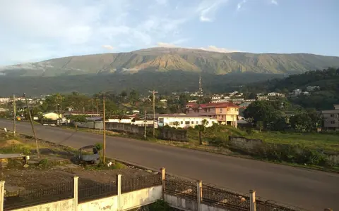
Mount Cameroon stands in Southwest Region, Cameroon, overlooking the Bight of Biafra on the Gulf of Guinea. Its summit is only about 25 km inland, so the edifice makes an abrupt transition from coast and foothills to high volcanic terrain.
The mountain is not a single smooth cone. It is a large, elongated volcanic mass built mainly from basaltic and trachybasaltic lava and fragmental deposits. Flank vents, cinder cones, craters, and overlapping lava fields complicate its outline, while Etinde forms a prominent satellite cone on the southwestern flank.
Summit ridge, fissures, and spreading flanks
The edifice is lengthened along a northeast–southwest trend. Many small cones and eruptive fissures follow this structural grain, showing that magma has repeatedly reached the surface away from the summit as well as near the upper mountain.
Successive lava flows form ridges, lobes, and rough fields that descend across older terrain; cinder cones rise as smaller steep landforms above them. Some historical flows have travelled far down the southwestern and southern flanks, and a 1922 flow reached the Atlantic coast.
Broad summit terrain
The high crest sits on an elongated edifice rather than a sharply isolated summit cone.
Fissure-controlled cones
Numerous cinder cones and craters trace eruption sites along the mountain's structural axis.
Overlapping lava fields
Basaltic flows spread toward foothills and, in places, the coastal plain.
Short catchments from crest to coast
Water drains outward from the mountain through steep, relatively short catchments. On the seaward side, channels descend rapidly toward coastal settlements and the Atlantic; elsewhere they cross foothills into surrounding lowlands. Lava ridges and young, permeable volcanic material can divert runoff or interrupt a simple radial pattern.
Intense rain promotes erosion where water concentrates in channels and moves loose volcanic sediment downslope. The close spacing of summit, flank, and coast means that volcanic topography directly organizes drainage basins around the lower mountain, including those leading toward Limbe.
Atlantic moisture lifted over steep relief
Moist air arriving from the Gulf of Guinea is forced upward across the southwestern face of the volcano. Cooling and condensation produce very heavy rainfall on the lower windward slopes, while precipitation and temperature vary strongly with elevation and exposure.
This orographic control helps sustain dense vegetation on humid lower slopes, but the highest terrain is cooler and more open. Fresh lava fields also create bare or thinly covered surfaces within otherwise wet terrain. Rainfall, weathering, and plant cover therefore produce a patchwork that partly reflects both elevation and the age of volcanic surfaces.
The continental end of the Cameroon Line
Mount Cameroon belongs to the Cameroon Volcanic Line, a major chain of volcanic centers and uplifted massifs extending southwest from the African continent across islands in the Gulf of Guinea. Unlike subduction-related chains such as the Sunda Arc at Mount Tambora, this volcano occupies an intraplate setting on continental crust.
Its coastal position connects continental highland relief with the offshore continuation of the volcanic line. Within the volcanoes hub, Mount Cameroon is a useful counterpart to ocean-island shield volcanoes such as Mauna Loa: both are dominated by basaltic lava, but their edifice shapes and crustal settings differ.