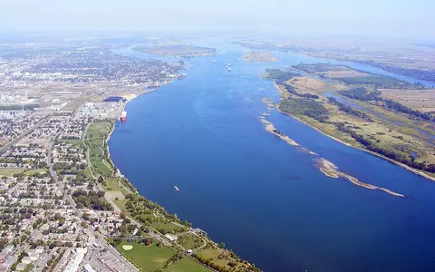

What the Saint Lawrence River is
The Saint Lawrence begins at the outflow of Lake Ontario, between Ontario and New York, and runs northeast along an international reach before continuing through Quebec. Downstream from Quebec City, the channel steadily widens and deepens into an estuary; beyond Pointe-des-Monts and Anticosti Island, the larger Gulf of St. Lawrence forms the passage to the Atlantic.
The river is only the final segment of a much longer drainage system. Water arriving at Lake Ontario has already passed through the upper Great Lakes and the connecting channels between them. This upstream lake storage gives the Saint Lawrence a steadier flow than many rivers draining basins of comparable size.
A continental lake basin with one outlet
The drainage basin reaches westward across the Great Lakes and their tributaries. Its southern and western margins gather runoff from interior plains and uplands, while the lower basin receives water from the Canadian Shield, the Adirondacks, and the Appalachian margin. The Ottawa River is the largest tributary entering the main stem, joining near Montreal after draining a broad Shield basin.
Because the Great Lakes hold an immense volume of water, rainfall and snowmelt are stored and released over long periods. Regulation at the Lake Ontario outlet further modifies levels and discharge, but the fundamental basin pattern remains that of several vast lake catchments funneled through a single northeastern passage.
Bedrock thresholds and lowland reaches
Near its source, the river threads through the Thousand Islands, where resistant Precambrian bedrock rises through the channel. Farther downstream, former rapids and bedrock-controlled narrows mark changes in gradient along the edge of the Canadian Shield and across the St. Lawrence Lowlands.
Broad reaches and islands alternate with confined channels. The lowlands occupy a structural depression between the Shield to the north and Appalachian uplands to the southeast, and were modified by Pleistocene ice and by the postglacial Champlain Sea. Marine and glacial sediments underlie many low, level surfaces beside the modern river.
Lake outlet and islands
Lake Ontario water passes through a bedrock-framed channel among the Thousand Islands.
Lowlands and tributaries
Wider channels, islands, and major confluences occupy the Montreal–Quebec corridor.
Tidal estuary
The channel widens, salinity rises, and deep basins connect the river with the gulf.
Shield, lowland, and Appalachian inputs
The Ottawa River supplies a major share of tributary inflow and can strongly affect spring levels around its confluence. North-shore rivers such as the Saint-Maurice and Saguenay descend from the Canadian Shield, often along steep valleys. South-shore tributaries including the Richelieu connect the main stem with Lake Champlain, while other rivers drain the Appalachian and lowland terrain of southern Quebec.
The Saguenay enters the estuary through a deep glacially excavated valley. Its cold, deep inflow illustrates how the lower Saint Lawrence gathers water from high-relief Shield catchments even as the main river occupies a broad lowland and estuarine corridor.
Lake storage, snowmelt, and seasonal ice
Great Lakes storage smooths short-term discharge changes at the head of the river. Farther downstream, tributary snowmelt produces a stronger spring signal, especially from the Ottawa and other northern catchments. Rainfall, evaporation over the lakes, groundwater, and managed outflow from Lake Ontario all contribute to variations across seasons and years.
Ice forms along parts of the river during winter, although its extent and movement vary with current, depth, temperature, and ice-control operations. Spring breakup and tributary freshets can raise water levels and move ice through constricted reaches. Downstream, tides increasingly influence water level and current, superimposing a marine rhythm on river discharge.
Continental seasons and maritime transition
The basin has a humid continental climate over most of its area, with cold winters, warm summers, year-round precipitation, and substantial seasonal snow. The Great Lakes moderate nearby temperatures and provide long-term water storage, while tributary basins farther northeast experience colder conditions and prolonged snow cover.
Toward the estuary and gulf, Atlantic influence increases. Cooler summers, persistent fog in some seasons, wind, sea ice, and storm-driven water-level changes become more important. The downstream corridor therefore marks a climatic as well as hydrologic transition from the continental interior to the northwest Atlantic margin.
From freshwater channel to marine gulf
Tidal influence reaches upriver beyond Quebec City, while the principal freshwater-to-saltwater transition lies farther downstream. The estuary widens markedly below the Île d'Orléans area and includes shoals, channels, islands, and deep troughs inherited partly from glacial erosion and later sedimentation.
Fresh surface water mixes with denser saline water moving landward at depth. The deep Laurentian Channel extends from the continental margin through the gulf and into the lower estuary, creating a strong connection between river discharge and ocean water. Anticosti Island divides the approach to the gulf, which reaches the Atlantic through Cabot Strait and the Strait of Belle Isle.
Great Lakes, lowlands, and Atlantic margin
The Saint Lawrence is best understood as both a river and the final passage of the Great Lakes–Saint Lawrence system. Upstream lakes regulate freshwater delivery; the St. Lawrence Lowlands guide the middle course; Shield and Appalachian tributaries add runoff and sediment; and the estuary transfers that water toward the gulf and Atlantic.
Within the atlas, the Mackenzie River offers a useful contrast because it also begins at a major lake but flows toward an Arctic delta. The Rhine River provides another comparison for a heavily modified river whose lower course enters a tidally influenced marine system.