
What the Mackenzie River is
The Mackenzie is the principal river of northwestern Canada. Its named main stem begins at the western end of Great Slave Lake and follows a generally north-northwest course entirely within the Northwest Territories before dividing through the Mackenzie Delta and reaching the Beaufort Sea.
The larger river system extends far beyond that main channel. Water reaches Great Slave Lake through the Slave River and ultimately from the Peace and Athabasca systems, while other major tributaries enter downstream. The basin therefore gathers runoff from the Rocky Mountain and Mackenzie Mountain headwaters, interior plains, boreal lowlands, large lakes, and subarctic terrain.
Great Slave Lake and the wider basin
Great Slave Lake forms the immediate source of the Mackenzie main stem. The lake stores and mixes inflow from a much larger upstream network, especially the Slave River, before water exits westward into the river. This lake-controlled beginning moderates short-term changes in flow compared with a river rising directly in steep headwater terrain.
Measured as a connected system through the Slave, Peace, and Finlay rivers, the drainage route extends much farther into western Canada. The watershed also includes Great Bear Lake, whose outflow enters through the Great Bear River, and numerous smaller lakes and wetlands that delay and redistribute runoff.
A broad northern lowland passage
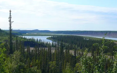
From Great Slave Lake, the Mackenzie crosses the Taiga Plains and occupies a broad valley bordered in places by plateaus and the eastern foothills of the Mackenzie Mountains. The river alternates between wide, island-divided reaches and more confined sections where resistant terrain narrows the valley.
Its gradient is generally low, so channel islands, sandbars, cut banks, side channels, and floodplain surfaces are recurring features. Alluvial deposits border much of the river, while discontinuous permafrost in the central valley and more continuous permafrost toward the delta influence bank stability, groundwater movement, slope drainage, and the response of fine-grained terrain to thaw.
Great Slave Lake outlet
Lake-stored water enters a broad river corridor across northern interior plains.
Tributary junctions
The Liard and Great Bear rivers enlarge the main stem as it passes plateaus and mountain-front terrain.
Delta approach
The valley opens toward a low alluvial plain where the channel divides into distributaries.
Mountain, lake, and lowland inputs
The Liard River is a major western tributary, delivering water and sediment from the northern Rocky Mountains and adjacent plateaus. Farther north, the Great Bear River carries the outflow of Great Bear Lake into the Mackenzie. The Arctic Red and Peel rivers join near the head of the delta after draining uplands and mountain terrain to the west.
These tributaries give the main river a mixed hydrologic signal. Mountain snow, rainfall, lake storage, wetland storage, and permafrost-affected drainage do not peak at exactly the same time, so downstream flow integrates conditions across several distinct physical regions.
Snowmelt, river ice, and flood pulses
Winter ice covers the Mackenzie for an extended cold season. Discharge rises during spring and early summer as snow melts across the basin, and breakup commonly progresses northward into reaches that remain frozen. Water backed up behind intact ice or ice jams can spread onto floodplains and through delta channels.
Large upstream lakes buffer part of the annual flow cycle, but tributary freshets still produce a pronounced seasonal rise. The river transports suspended sediment from eroding banks and tributary basins toward the delta, where changing velocity and channel division promote deposition before finer material and freshwater move onto the Beaufort Sea shelf.
Continental cold from boreal forest to tundra
The basin spans several climate settings, but long winters and seasonal snow storage are widespread. Southern and western headwaters receive runoff shaped by higher relief, while the main valley has a strongly continental climate with cold winters, relatively short summers, and modest precipitation.
Northward, the thaw season shortens and permafrost becomes a stronger control on soils, slopes, and shallow subsurface drainage. The river nevertheless transfers heat and water through the landscape: channels and deeper lakes can maintain unfrozen ground beneath them even where surrounding delta surfaces are underlain by permafrost.
Mackenzie Delta and Beaufort Sea
Near the Arctic coast, the Mackenzie divides across a low alluvial delta roughly 150 kilometres long and up to about 60 kilometres wide. A network of distributary channels encloses thousands of shallow lakes and floodplain surfaces. The Peel River adds water and sediment near the delta head, while repeated flooding, bank erosion, deposition, lake change, and permafrost processes continually shape the plain.
Beyond the distributary mouths, freshwater and suspended sediment enter the shallow Beaufort Sea shelf. River discharge helps form a seasonal freshwater plume and supplies sediment to the Arctic coastal margin, completing a basin connection that begins in the western Canadian interior.
A basin assembled through lakes and rivers
The Mackenzie is best read as the downstream axis of an interconnected freshwater system. Great Slave Lake separates the named main stem from the Slave-Peace-Athabasca network, while Great Bear Lake joins from the east and mountain tributaries enter from the west.
Within the atlas, that lake-and-river structure makes the Mackenzie a useful cold-region counterpart to the Lena River and Ob River. All three carry continental runoff north to Arctic seas, but the Mackenzie is especially distinguished by the large lakes embedded within its drainage network and by its position between western mountains and the Canadian Shield margin.