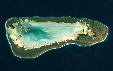

What the Seychelles reef system is
The Seychelles reefs do not form a single barrier or continuous chain. They are a set of geographically distinct reef complexes distributed among island groups and submarine banks. Around Mahé, Praslin, La Digue, and nearby Inner Islands, coral growth commonly rims rocky coasts or occupies shallow bank surfaces. Farther southwest and south, the Amirantes, Alphonse, Farquhar, and Aldabra groups include atolls, platform reefs, sand cays, and limestone islands.
The relationship between reef and island changes across the archipelago. High granitic islands supply short slopes, rocky headlands, and small drainage basins beside reef flats. Outer coralline islands are low landforms made chiefly of reef-derived sand, rubble, or older limestone, so their form is more directly tied to waves, currents, and carbonate accumulation.
Scattered across the western Indian Ocean
The Inner Islands cluster near 4° south on the Seychelles Bank, roughly 1,500 kilometres east of the East African coast. The Outer Islands extend in groups toward the southwest, bringing the archipelago closer to northern Madagascar and the channel between Madagascar and the equatorial Indian Ocean.
Large reaches of deep water separate several island groups. The Amirantes lie southwest of the main bank, while the Alphonse group, Farquhar group, and Aldabra group occupy other isolated banks farther outward. This broken distribution creates a reef province linked by regional currents rather than by one shared shallow shelf.
Fringing margins, platforms, and atolls
Inner-island reefs occupy an irregular setting shaped by granite coasts and the shallow Seychelles Bank. Fringing reefs and reef flats widen in sheltered embayments and around low neighboring islands, while channels and deeper gaps interrupt them near headlands and passages. Patch reefs rise from bank and lagoon floors where depth and water movement permit reef growth.
The Outer Islands show more strongly carbonate-built forms. Atoll rims may enclose broad lagoons and carry narrow islands on their reef flats. Aldabra has a raised limestone rim cut by channels into a large tidal lagoon; other groups include submerged banks, platform reefs, partial rims, and small sand cays rather than complete textbook atolls.
Granite and fringing reefs
Rocky islands rise from a shallow bank, with reefs arranged around coves, passages, and lower coastal margins.
Coralline banks and atolls
Low islands and reef rims occupy isolated platforms surrounded by deep ocean water.
Different degrees of enclosure
Open bank surfaces, shallow reef lagoons, and channel-linked atoll basins create varied water exchange.
High granite within, low carbonate without
The Inner Islands are exposed fragments of continental crust. On Mahé, steep granite slopes rise directly behind short coastal plains and reach 905 metres at Morne Seychellois. The surrounding Seychelles Bank is comparatively shallow, but its outer edge descends toward the deep Mascarene Basin and Somali Basin sectors of the Indian Ocean.
Most Outer Islands have very low surface relief, although older reef limestone is locally raised above present sea level. Their strongest topographic contrast lies offshore, where shallow platforms and atoll rims give way to steep submarine slopes. Beaches, storm ridges, dunes, solution features, and lagoon margins supply much of the smaller-scale relief.
Runoff, tides, and open-ocean exchange
Short streams drain the wetter, steeper granitic islands, carrying freshwater and fine land-derived material toward bays and nearshore reefs. Catchments are small, so discharge responds quickly to rainfall. On low coralline islands, porous sand and limestone favor infiltration and thin freshwater lenses rather than permanent rivers.
Tides drive water through reef passes and across shallow flats, especially where atoll lagoons narrow into channels. Waves and currents move carbonate sand between fore reefs, reef flats, beaches, and lagoon floors. Exposure differs sharply between open ocean margins, enclosed lagoons, and the more sheltered sides of islands.
Tropical warmth and monsoon reversal
Seychelles has a warm tropical marine climate governed by the seasonal movement of the equatorial rain belt and the reversal of monsoon winds. The northwest monsoon is generally warmer and wetter around the Inner Islands, while the southeast trade-wind season is typically cooler, drier, and windier.
Wind direction controls which reef faces receive the strongest waves and where loose sediment accumulates. Rainfall varies between the mountainous central islands and lower outer groups. The islands nearest the equator are generally outside the main tropical-cyclone belt, but southern outer groups are more exposed to cyclone-generated seas and occasional direct storm effects.
Banks between East Africa and the central ocean
The reefs occupy a transition between equatorial circulation, the waters north of Madagascar, and the broader western Indian Ocean current system. Seasonal currents reverse or change strength with the monsoon, while flows around banks and through channels create local differences in sediment transport and lagoon flushing.
Within Geography Atlas, the system belongs in the reef hub. Its outer atolls can be compared with the ridge-based Maldives Coral Reefs and Chagos Archipelago Reefs, while its granitic inner setting provides an important contrast to both.