
What the Chagos reef system is
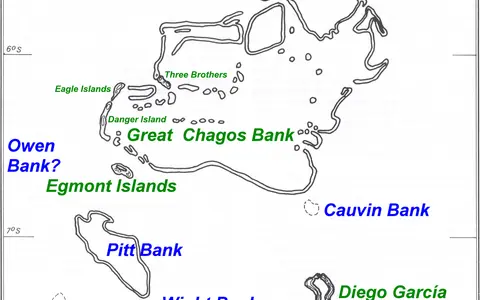
Chagos is an archipelagic reef province rather than a single reef. Its principal structures include the Great Chagos Bank, Peros Banhos, Salomon Islands, Egmont Islands, Blenheim Reef, Speakers Bank, and the Diego Garcia atoll. Some form recognizable atoll rings with central lagoons; others are mostly submerged banks whose shallow margins approach the sea surface.
Dry land occupies only a minute part of the total platform area. The islands are low accumulations of reef-derived sand and rubble built on reef rims, while most of the physical landscape remains underwater. Platform shape, lagoon depth, passages, and outer slopes therefore define the archipelago more clearly than the scattered shorelines do.
South of the Maldives
The archipelago lies near 4–7° south latitude and roughly 71–73° east longitude, about midway between East Africa and Indonesia and south of the Maldives. Open Indian Ocean surrounds every reef group. There is no adjoining continental shelf, large island mass, or river-fed coastal plain.
The reefs are arranged across a wide, irregular ridge sector. Great Chagos Bank occupies the central area; Peros Banhos and Salomon lie to the north, Egmont to the southwest, and Diego Garcia to the southeast. Deep channels separate these shallow platforms and allow oceanic water to circulate between them.
Rims, banks, lagoons, and passages
Reef form varies across the group. Diego Garcia has a horseshoe-shaped rim around a broad, shallow lagoon with an opening in the north. Peros Banhos and Salomon consist of broken atoll rims carrying small islands and enclosing lagoon water. Great Chagos Bank is much larger in plan, but much of its rim and interior remain submerged, with islands confined to a few peripheral sectors.
Waves break on exposed outer margins, then lose energy across reef crests and flats. Passes interrupt the rims and connect lagoons with the open ocean. Patch reefs and sediment floors occupy protected interiors, while sand cays and elongated islands form where waves and currents repeatedly concentrate carbonate sediment.
Ocean-facing rim
Reef crests and fore-reef slopes mark the abrupt edge between shallow platforms and deep water.
Enclosed marine basin
Broken rims surround lagoon floors, patch reefs, channels, and areas of carbonate sediment.
Low sediment landforms
Sand and coral rubble accumulate on limited parts of the rims as narrow islands and cays.
Shallow platforms over deep-ocean slopes
The greatest relief is submarine. Reef flats lie close to sea level, lagoons descend across shallow platform interiors, and the outer flanks fall steeply into water thousands of metres deep. The reefs are carbonate caps on subsided volcanic foundations, not extensions of a continental landmass.
Above water, relief is slight. Beaches, berms, storm ridges, and shallow interior depressions account for most local height differences, and island surfaces generally stand only a few metres above sea level. With no hills or broad catchments, drainage is short, diffuse, and mostly downward through porous sediment.
Ocean exchange dominates
Tides, wind-driven currents, swell, and flow through reef passages control water movement. Lagoon circulation differs according to rim shape: broad or numerous openings promote exchange, while more enclosed sectors retain water longer. Waves also move sand and rubble across reef flats and reshape beaches around the seasons.
The islands have no permanent rivers. Rain infiltrates permeable coral sand and can form thin freshwater lenses above saline groundwater, while excess water drains directly toward lagoon or ocean shores. The absence of continental runoff means the wider system is governed principally by oceanic water, locally modified by rainfall, evaporation, and lagoon residence time.
Equatorial warmth and monsoon influence
Chagos has a warm, humid tropical marine climate with relatively small annual temperature changes. Its position close to the equator places it under the seasonal migration of tropical rain belts and the broader Indian Ocean monsoon circulation. Wind direction, rainfall, cloud cover, and sea state vary through the year.
Persistent trade and monsoon winds generate waves that distinguish exposed outer coasts from sheltered lagoon shores. Equatorial currents and seasonally reversing flows connect the reefs with waters to the north, east, and west. Tropical storms are less frequent this close to the equator than farther south, but swell, heavy rain, exceptional water levels, and long-term sea-level change still rework low islands.
Maldives, Mascarene Basin, and open ocean
Chagos forms the southern continuation of the Laccadive–Maldives–Chagos Ridge. The Maldives Coral Reefs extend the ridge-aligned atoll pattern northward, while deep water of the central Indian Ocean and adjacent basins surrounds Chagos on all sides. Channels between banks form routes for regional currents rather than shallow links between platforms.
Within Geography Atlas, Chagos belongs in the reef hub as an oceanic atoll-and-bank record. Its steep platform edges and isolated setting can be compared with the Tubbataha Reefs, while its scattered broad banks differ from the long continental-shelf alignment of the Great Barrier Reef.