
Shelf geography
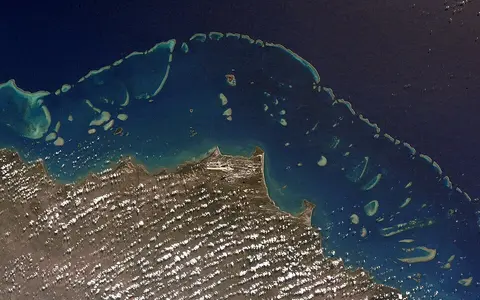
The Great Barrier Reef occupies the marine margin of northeastern Australia, alongside Queensland. The Reef Authority describes the Marine Park as extending approximately 2,300 kilometres along the coast, from the northern tip of Queensland to just north of Bundaberg. Its width varies between 60 and 250 kilometres. These dimensions describe a broad marine region containing thousands of separate reefs, islands and intervening waters; they should not be read as the dimensions of one continuous coral wall.
The Marine Park covers 344,400 square kilometres, but coral reefs occupy only about seven per cent of it. Seagrass beds, mangroves, sandy seabeds, algal and sponge gardens, and communities between reefs are also part of the system. This distinction matters when reading a map: the protected area's boundary encloses a much wider range of environments than the individual reef patches visible in aerial photographs. Source: Reef Authority facts.
Reef chains and changing sea levels
Across the continental shelf, the system includes reefs fringing the shore, reefs farther offshore and exposed outer reefs. Beyond them, the World Heritage property includes continental slope and deep ocean waters. Its geography therefore has both an along-coast pattern and a cross-shelf pattern: moving seaward changes the setting as well as the depth.
UNESCO describes repeated exposure and flooding through glacial and interglacial cycles. When sea levels fell, former reefs became eroded limestone hills and rivers crossed land that is now submerged. Rising seas subsequently flooded that landscape, isolated continental islands and enabled renewed coral growth. The present arrangement records this history as well as ongoing erosion and accumulation. Continental islands and sandy coral cays consequently represent different kinds of land within the reef system. Treating every island as a coral-built feature would obscure that distinction. Source: UNESCO's geological account.
How living corals build structure
Hard corals are colonies of animals called polyps. They produce calcium carbonate skeletons that form the reef's hard surface, providing shelter and surfaces for other organisms. Soft corals do not produce the same hard limestone skeleton. The distinction connects the living community to the physical landform: different organisms contribute differently to its structure.
Most shallow-water hard corals contain microscopic algae in their tissues. Through photosynthesis, these partners supply much of the coral's nutrition, while the coral also captures small drifting organisms. This relationship helps explain the importance of light to reef growth. When the partnership breaks down, coral bleaching occurs; prolonged disruption can cause starvation and death. A reef's physical framework and the condition of its living coral cover are therefore distinct aspects of the same place. Source: AIMS on coral biology.
Light across the shelf
Shallow water does not automatically mean abundant light at the seabed. Suspended particles scatter and reduce light, so turbid inshore waters can provide less illumination than clearer, deeper offshore waters. The Reef Authority's Outlook Report identifies greater wet-season exposure to sediment and phytoplankton near shore, while middle and outer shelf reefs generally experience clearer conditions. Depth and water clarity must therefore be considered together when explaining where photosynthetic organisms can grow. Source: Outlook Report, Light.
Connections with the adjacent coast
Rivers connect the reef's marine setting with erosion in mainland catchments. Fine silt and clay can travel along or away from the coast, remain suspended, and later be stirred up again. Sediment retained in inshore areas can thus affect water clarity beyond the original runoff event. Heavy sediment loads can restrict photosynthesis, interfere with filter-feeding animals and affect coral reproduction and early development. Maintaining vegetation cover and reducing erosion in gullies help limit the material entering waterways. The reef's coastal adjacency is consequently a functional connection between land use, river transport and marine conditions. Source: Queensland sediment explainer.