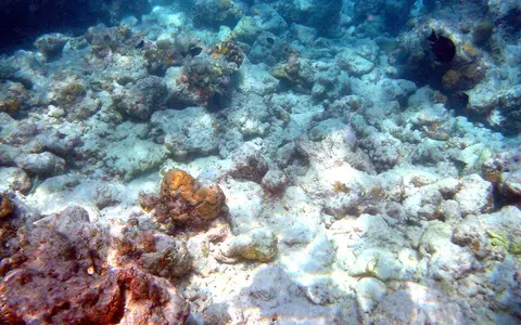

What the Maldives reef system is
The Maldives Coral Reefs are not one continuous reef wall. They are a linked archipelago of large atolls and smaller reef structures arranged in a narrow north–south belt. Each major atoll contains some combination of an outer rim, deep natural passes, an interior lagoon, patch reefs, submerged knolls, ring-shaped faros, sandbanks, and reef islands.
Dry land occupies only a small fraction of this marine landscape. Most islands are low accumulations of carbonate sediment produced on surrounding reefs and moved by waves and currents. The reef platform, rather than the island shoreline alone, is therefore the basic landform unit.
Across the equatorial Indian Ocean
The chain lies southwest of the Indian subcontinent and Sri Lanka, between the Arabian Sea sector to the north and the open equatorial Indian Ocean to the south. Northern atolls continue the regional line of the Lakshadweep reefs, while the southern end points toward the Chagos Archipelago.
In plan, the central Maldives separates into eastern and western rows with passages between them. The chain narrows and changes form toward both ends. This arrangement creates ocean-facing margins, internal channels, and atoll lagoons with different degrees of shelter and exchange.
Atoll rims, faros, lagoons, and passes
The outer rims are broad reef platforms broken by channels that connect lagoon water with the open ocean. Some atolls are relatively enclosed; others have interrupted rims and many passages. Interior lagoons commonly reach tens of metres in depth and contain patch reefs and knolls rising from their floors.
A distinctive Maldivian element is the faro: a small ring-shaped reef, often with its own sandy lagoon. Faros occur along some atoll rims and within larger lagoons, producing reef-within-reef patterns. Islands develop where waves and currents accumulate sand and coral rubble on stable parts of these platforms.
Wave-facing reef edge
Reef flats and fore-reef slopes mark the transition from shallow atoll platforms to deep ocean water.
Deep enclosed basin
Atoll lagoons contain sediment floors, patch reefs, submerged knolls, and local ring reefs.
Low carbonate landforms
Sand, gravel, and coral rubble accumulate above reef platforms as narrow, mobile islands and banks.
Shallow platforms above deep ocean
The strongest relief is submarine. Atoll flats lie near sea level, lagoon floors descend through shallow to moderately deep water, and outer slopes fall steeply toward the surrounding Indian Ocean. This sharp contrast reflects reef growth on the crest and flanks of a buried volcanic ridge rather than on a broad continental shelf.
The islands themselves have little topographic relief. Their surfaces are generally only a few metres above mean sea level, with beach ridges, storm-built rubble, shallow depressions, and locally reclaimed ground providing the main height differences. There are no mountain catchments or permanent rivers.
Ocean exchange through reef channels
Tides, waves, monsoon-driven currents, and flow through reef passes govern the system. Water crosses shallow rims during energetic conditions and moves through deeper channels between the lagoons and open sea. The size and number of passes influence how quickly each lagoon exchanges heat, salt, sediment, and suspended material with surrounding waters.
On land, highly permeable coral sand allows rain to infiltrate rapidly and form thin freshwater lenses above salt water on some islands. Surface streams are absent, so the reefs receive no large river-borne sediment load. Local runoff and groundwater remain important at island scale, but ocean circulation dominates the wider reef hydrology.
Equatorial warmth and reversing monsoons
The Maldives has a warm, humid tropical marine climate. Seasonal changes are controlled chiefly by the South Asian monsoon: southwesterly winds generally bring the wetter, rougher part of the year, while the northeast monsoon more often brings drier conditions and different wave and current directions.
The elongated chain crosses a rainfall gradient, with southern atolls generally wetter than northern ones. Monsoon shifts redistribute reef sediment and alter which island shores are windward or sheltered. Long-period swell, storm waves, exceptional sea levels, and gradual sea-level change also rework reef flats, beaches, and passes.
Lakshadweep, Chagos, and the ridge system
The Maldives occupies the central section of the Laccadive–Maldives–Chagos Ridge. Lakshadweep extends the reef-and-atoll line northward toward India, while Chagos continues it southward into the central Indian Ocean. Deep channels across and between these ridge sections connect the Arabian Sea with equatorial waters.
Within Geography Atlas, the system belongs in the reef hub as a broad oceanic atoll-chain record. Its lagoon and rim geometry can be compared with the offshore Tubbataha Reefs, while its open-ocean foundation contrasts with continental-shelf systems such as the Great Barrier Reef.