
What Saya de Malha Bank is
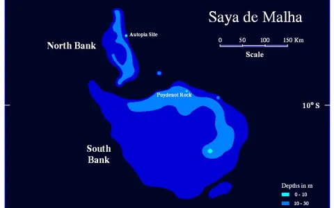
Saya de Malha is a bank-scale marine landform rather than an island or a single narrow reef. Its upper surface includes a submerged ring reef, shallow and deep lagoon zones, patchy carbonate seabeds, and a broader limestone platform extending southward. No part rises above sea level.
The name is also used for a two-bank complex. The much larger southern Saya de Malha Bank and smaller Ritchie Bank to its north are separated by a channel around 1,000 metres deep. Together they account for the widely reported area of roughly 40,800 square kilometres.
A remote central plateau
The bank lies near 9°–12° south and 59°–62° east, northeast of Madagascar and southeast of the main Seychelles group. Agaléga lies more than 300 kilometres to the west, while other exposed islands are still farther from much of the bank.
Saya de Malha occupies the central Mascarene Plateau, an elevated submarine tract running south from the Seychelles region toward the banks and islands around Mauritius. Ritchie Bank borders it to the north; Nazareth Bank lies to the south beyond a deep transverse passage. Deep ocean basins flank the plateau to east and west.
Ring reef, lagoons, and southern platform
The shallowest part of the bank forms a submerged ring reef whose crest is generally tens of metres below the surface and reaches about 8 metres at its highest point. The rim is incomplete and open toward the south, so it does not enclose the interior like a continuous, near-surface atoll reef.
Inside and beside the rim, a shallow lagoon mostly occupies depths of about 40–100 metres, while a deeper lagoon descends through roughly 100–200 metres. A limestone plateau continues southward at greater depth. Reefs, sediment sheets, hardgrounds, rhodolith beds, and seagrass-covered areas create smaller-scale variation across the platform top.
Submerged ring reef
A shallow reef arc defines the northern bank top but remains entirely below sea level.
Two lagoon-depth zones
Shallow and deep lagoon floors give the platform a broad, stepped interior profile.
Limestone plateau
A deeper carbonate surface extends beyond the open side of the ring structure.
Carbonate cover above volcanic crust
The bank rises from surrounding ocean floor more than 2,000 metres deep, giving its outer flanks much stronger relief than the gently varying bank top. Breaks in slope, gullies, and channels mark the descent from shallow platform water into the adjacent deep ocean.
Its foundation belongs to the volcanic Mascarene Plateau, built during movement of the Indian Plate over the Réunion hotspot. Carbonate sediment and reef growth later accumulated on this elevated base. The modern bank is described as a drowning carbonate platform: much of its active reef and sediment-producing surface lies at mesophotic depths rather than close to sea level.
Current flow across a submerged obstacle
The bank has no rivers, catchments, or land-derived runoff. Water exchange occurs across the reef rim and over the whole platform, driven by tides, winds, waves, and regional currents. The open southern rim and deep channel beside Ritchie Bank connect lagoon and bank-top water directly with the surrounding ocean.
The westward-flowing South Equatorial Current meets the Mascarene Plateau and is split around and through its banks. Flow over edges and through deep passages promotes vertical mixing and localized upwelling. Internal waves also form where density-layered water crosses steep bank relief, moving energy between deep water, slopes, and the shallow platform.
Tropical ocean and trade-wind controls
Saya de Malha lies in a warm tropical marine setting south of the equator. The southeast trade winds dominate much of the year, while the seasonal migration of tropical wind and rain belts changes cloud, rainfall, wave direction, and upper-ocean mixing.
Because there is no land, climate acts directly through the sea surface. Wind stress drives currents across the platform, swell reaches its exposed margins, and sunlight penetration helps determine where carbonate-producing organisms and seagrasses can occupy the bank top. Tropical cyclones are less frequent here than farther south, but storm-generated swell can still cross the bank.
A link in the Mascarene chain
Saya de Malha is one of several broad banks aligned along the Mascarene Plateau. The shallow Seychelles Bank lies to the north, while Nazareth Bank, Cargados Carajos, and Mauritius continue the elevated submarine trend southward. Deep channels interrupt this chain and funnel part of the South Equatorial Current.
Within the reef hub, Saya de Malha can be compared with the Seychelles Coral Reefs, which include both granitic island margins and outer coralline banks. It also contrasts with Great Chagos Bank: both are immense Indian Ocean carbonate platforms, but Great Chagos carries a few low islands while Saya de Malha remains wholly submerged.