
What Great Chagos Bank is
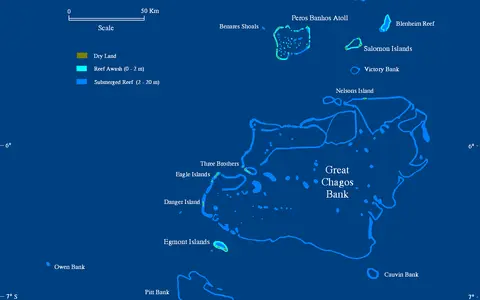
Great Chagos Bank is one component of the wider Chagos Archipelago reef system, but it is a single bank-scale atoll rather than the whole archipelago. In plan it consists of a broad, irregular platform edged by reef growth. Much of the rim remains below the sea surface, so the structure does not appear as a continuous ring of land.
Dry land is restricted to small islands on limited sectors of the rim, including the Eagle Islands, Three Brothers, Danger Island, and Nelsons Island. These islands are accumulations of reef-derived sand and rubble. Their combined area is minute beside the bank, whose main landforms are submerged.
A central Chagos platform
The bank occupies the central and western part of the Chagos Archipelago, roughly between 5° and 7° south latitude and 71° and 73° east longitude. Peros Banhos and the Salomon Islands lie to the north, while the Egmont Islands and Diego Garcia occupy separate platforms to the southwest and southeast.
Open Indian Ocean surrounds the bank, and deep channels isolate it from neighboring atolls. Its outline extends roughly 150 kilometres from north to south and more than 100 kilometres across in places, although the irregular rim makes any single width approximate. There is no continental shelf or river-fed coast nearby.
A broken rim and broad interior
The outer reef margin is strongest along parts of the north, west, and south. Elsewhere the atoll rim is deeply submerged or interrupted, allowing open-ocean water to cross the bank. Reefs, shoals, passages, and deeper channels therefore replace the nearly closed ring seen at some smaller atolls.
Inside the rim lies an extensive lagoon-like platform with variable depths, patch reefs, banks of carbonate sediment, and deeper interior areas. Waves break and dissipate on shallow outer reefs, while tidal and wind-driven flows pass across gaps and redistribute sand and coral rubble.
Reef rim
Shallow reef sectors mark the transition from the bank top to steep deep-ocean slopes.
Lagoon platform
A broad submerged interior contains reefs, shoals, sediment floors, and deeper water.
Low rim islands
Small sandy islands occupy only a few northern and western segments of the bank.
Carbonate growth above a volcanic base
The bank stands on the southern part of the Chagos–Laccadive Ridge, a chain of submarine volcanic foundations also underlying the Maldives farther north. As the volcanic base subsided and eroded over geological time, carbonate-producing reef communities maintained growth near sea level, building a thick platform above it.
Its most pronounced relief occurs below water. The platform top lies in shallow to moderately deep water, whereas the outer flanks descend rapidly toward the deep Indian Ocean floor. Above sea level, beaches, storm ridges, and low interior island surfaces create only slight local relief.
Open exchange across a submerged rim
Ocean exchange dominates the bank. Tides, swell, and wind-driven currents move through broad openings and across submerged rim sectors, linking the interior directly with surrounding waters. Exchange is therefore less restricted than in an atoll with a narrow pass and an otherwise continuous reef crest.
The low islands have no permanent rivers or broad drainage basins. Rainfall either infiltrates porous coral sediment, temporarily supporting thin freshwater lenses, or drains over short distances to the sea. With no continental runoff, sediment and water properties are governed mainly by reef production, ocean circulation, rainfall, and evaporation.
Equatorial marine controls
Great Chagos Bank has a warm tropical marine climate with small seasonal temperature ranges. Its near-equatorial position places it beneath migrating rain belts and within the wider Indian Ocean monsoon system, bringing seasonal changes in winds, rainfall, cloud, waves, and surface currents.
Persistent ocean swell acts on exposed rim sectors, while locally generated waves rework shallow flats and island shores. Tropical cyclones are uncommon so close to the equator, but distant storm swell, heavy rainfall, unusually high water levels, and long-term sea-level change can still alter beaches and low reef islands.
One bank within a ridge-aligned chain
Great Chagos Bank belongs to a sequence of carbonate platforms developed along the Chagos–Laccadive Ridge. The Maldives Coral Reefs continue the ridge-aligned pattern northward, while nearby Chagos atolls occupy separate volcanic highs divided by deep water.
Within the reef hub, the bank is useful for comparing a mostly drowned atoll rim with the more clearly enclosed platforms of smaller oceanic atolls. Its scale and open interior also distinguish it from long barrier reefs attached to continental shelves.