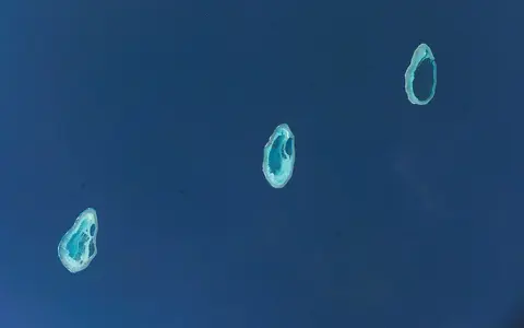

What the Rowley Shoals are
The Rowley Shoals are a short chain of three detached carbonate platforms: Mermaid Reef in the northeast, Clerke Reef in the middle, and Imperieuse Reef in the southwest. They are shelf atolls—ring-shaped reef systems built on a continental-margin foundation rather than on isolated volcanic islands in an ocean basin.
All three have a broadly pear-shaped plan, with the narrower end pointing north. Shallow reef flats emerge at low tide, lagoons occupy their interiors, and narrow passages cut the eastern rims. Deep channels between the shoals prevent them from forming one continuous reef system.
Beyond the coast west of Broome
The chain lies roughly 300 kilometres west to northwest of Broome, Western Australia, near the outer edge of the broad North West Shelf. The shoals are arranged northeast to southwest and stand about 30–40 kilometres apart. Mermaid Reef is farthest north and east; Imperieuse Reef is farthest south and west.
The nearest mainland lies well beyond the horizon, so the shoals receive no direct river discharge. Their immediate geographic connections are instead to the surrounding shelf-edge sea, the deeper continental slope to the west, and the wider group of offshore reef platforms that includes Scott and Seringapatam reefs farther north.
Rims, lagoons, passages, and cays
Each atoll has a shallow, wave-exposed outer rim enclosing lagoon water and sand. Openings about two-thirds of the way along the eastern side connect the interiors with the surrounding sea. Waves break strongly along the western rims, while tidal flows are concentrated through the narrower eastern passages.
The interiors become more compartmented southwestward. Mermaid has one comparatively open lagoon, reaching about 20 metres deep. Clerke and Imperieuse contain shallower, more complex lagoon systems divided into three principal basins, with patch reefs, coral pinnacles, sand sheets, and channels interrupting the lagoon floors.
Single open lagoon
The smallest and northeastern atoll has one deep lagoon, one main eastern passage, and no permanent land above high water.
Divided lagoon and cay
Three connected lagoon basins lie inside the rim, while elongated Bedwell Island occupies the northern sector.
Broadest platform
The southwestern atoll is the largest of the three and contains divided lagoons and Cunningham Island.
Shallow platforms above steep flanks
The shoals cap the Scott Reef–Rowley Shoals Platform, a plateau adjoining the outer continental shelf. Their reef tops occupy the sunlit surface zone, but their outer slopes descend abruptly. On their landward sides, Mermaid rises from about 440 metres, Clerke from about 390 metres, and Imperieuse from about 230 metres; the western sides fall especially steeply toward the continental margin.
This progressive change in foundation depth helps explain differences in development among the three atolls. Their cross-sections compress a large amount of relief into a short horizontal distance: exposed reef flat and low sand cay give way to lagoon basin, reef rim, fore-reef slope, and hundreds of metres of surrounding water.
Tidal exchange through eastern passages
There are no streams or permanent freshwater bodies. Water exchange is controlled by tides, ocean swell, wind, and currents. At Mermaid Reef, a tidal range of roughly 4.5 metres moves water through the main passage; across the chain, rising tides flood reef flats and lagoons, while falling tides drain through gaps and channels.
Passage width, lagoon depth, and the distribution of patch reefs cause circulation to differ among the atolls. The open Mermaid lagoon permits a simpler exchange pattern, whereas Clerke and Imperieuse divide flow among several basins. Strong water movement sorts carbonate sand and rubble, maintains channels, and shifts sediment across reef flats and cays.
Tropical seasonality and open-ocean exposure
The Rowley Shoals lie in a tropical marine climate. Seasonal shifts in winds and rainfall reflect the northwestern Australian monsoon, but distance from land limits direct runoff and leaves ocean conditions as the main control on the reef waters. Sea temperatures remain warm through the year, with a marked seasonal cycle.
Tropical cyclones periodically cross the eastern Indian Ocean and can bring intense winds, high waves, storm surge, and rapid rearrangement of coral rubble and cay sand. Regional circulation connects the shoals with the Indonesian Throughflow and the warm currents moving along Western Australia's margin, while tides and steep topography intensify mixing locally.
Between shelf and eastern Indian Ocean
The shoals mark a transition from the broad, shallow North West Shelf to the steep continental margin and deeper eastern Indian Ocean. They belong to the same outer-margin alignment as Scott and Seringapatam reefs, but form a distinct southern trio. Their isolated setting contrasts with the turbid, tide-dominated coastal reefs nearer the Kimberley mainland.
Within Geography Atlas, the Rowley Shoals belong in the reef hub and provide a focused outer-shelf example within the wider Kimberley Reefs province. Their compact chain of shelf atolls also contrasts with the nearshore fringing form of Ningaloo Reef farther south.