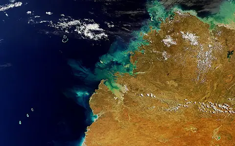

What the Kimberley Reefs are
Kimberley Reefs is a collective geographic name for numerous reef systems associated with the Kimberley coast and the adjoining North West Shelf. The province includes coral veneers on rocky foundations, fringing reefs around islands, broad intertidal platforms, submerged banks, and ocean-facing reef rims. Water depth, bedrock, tidal energy, and distance from river runoff vary greatly among them.
This is not a barrier reef comparable to a single coast-parallel chain. The inshore systems form a maze among peninsulas, archipelagos, drowned valleys, sounds, and tidal channels. Farther west and northwest, reefs such as the Rowley Shoals and Scott Reef stand as isolated carbonate platforms near the outer shelf, separated from land and from one another by deep water.
Across the Kimberley margin
The coastal reef zone follows the tropical northwest of Western Australia, from waters north of Broome around Dampier Peninsula and the Buccaneer Archipelago to Camden Sound, the Bonaparte Archipelago, and the complex coast toward the Joseph Bonaparte Gulf. Reefs occupy bays and sounds, edge islands, bridge narrow passages, and spread across shallow rock platforms.
The offshore zone reaches across the North West Shelf toward its outer margin. The Rowley Shoals lie west of Broome, while Scott Reef lies farther north. These oceanic systems are commonly grouped with the broader northwest Australian reefs, but their clear-water, steep-sided shelf-edge setting differs sharply from the turbid and strongly tidal mainland coast.
Platforms, rims, channels, and terraces
Many inshore reefs have grown over resistant Precambrian sandstone or around rocky islands. Montgomery Reef is a clear example: its broad, shallow platform is fundamentally an old terrestrial landform drowned by rising sea level and covered by younger marine deposits, corals, and calcareous algae. Other reefs fringe shorelines or occupy the sills and margins of drowned valleys.
At low tide, platform tops may emerge and drain through gutters, creeks, and falls into adjacent channels. Offshore reefs have a different profile. Their reef flats and rims cap submerged foundations, enclose shallow lagoons in some places, and descend down steep outer slopes toward the deep shelf margin.
Rock-based platforms
Reef growth commonly mantles sandstone foundations within a maze of islands, bays, and tidal passages.
Banks and patch reefs
Submerged shoals and discontinuous reef patches interrupt broad areas of shelf sediment.
Isolated reef rims
Atoll-like platforms rise abruptly from deeper water near the continental-shelf edge.
A drowned, low-gradient continental edge
The Kimberley coastline is the flooded edge of an ancient plateau cut into durable, nearly horizontal sandstone and older deformed rocks. Post-glacial sea-level rise drowned river valleys and lower terrain, leaving a highly indented coast of cliffs, peninsulas, islands, sounds, and narrow straits. Modern reefs occupy this inherited relief rather than forming on a smooth coastal plain.
Seaward, the broad North West Shelf carries shallow banks and reef foundations far from the present shore. Near the outer margin, isolated platforms rise steeply from deeper shelf and slope water. The full cross-shelf sequence therefore runs from rugged plateau catchments and ria-like inlets through shallow platforms and banks to shelf-edge reefs and the continental slope.
Tidal exchange and seasonal runoff
Tides are the strongest recurring control on inshore water movement. Large tidal ranges alternately flood and uncover reef flats, while constricted passages accelerate currents and generate eddies, standing waves, and intense mixing. On broad platforms, falling water drains toward channels and pools; around reef edges, this repeated exchange moves sediment and creates strong gradients in depth and exposure.
Coastal water is often turbid because currents resuspend fine seabed sediment and wet-season rivers deliver runoff from the plateau. Freshwater influence is strongest near estuaries after heavy rain, whereas water becomes clearer offshore. At the shelf edge, waves, internal tides, and ocean currents replace river discharge and coastal resuspension as the dominant controls.
Monsoon seasonality on a tropical shelf
The region has a tropical monsoonal climate with a hot, humid wet season and a drier, less humid winter. Most rain falls during the warm season in thunderstorms, monsoon episodes, and tropical cyclones. Flood pulses can lower coastal salinity and carry sediment through estuaries, while the long dry season reduces river input and allows evaporation to become more influential in shallow embayments.
Cyclones periodically produce high waves, storm surge, heavy runoff, and physical reworking across both coastal and offshore reefs. Beyond the inlets, circulation is connected to the Indonesian Throughflow and the southward movement of warm water along Western Australia. Local winds, tides, and shelf topography modify that regional flow, so exposure differs substantially from protected inner sounds to open shelf-edge rims.
Plateau, shelf, and deep ocean
The reefs link three major physical zones. Inland, short seasonal rivers drain a dissected sandstone plateau. Along the coast, drowned valleys, mudflats, mangrove-lined estuaries, rocky islands, and reef platforms form a tightly interwoven intertidal landscape. Offshore, banks and atoll-like reefs connect the shallow shelf with deep eastern Indian Ocean water.
Within Geography Atlas, the province belongs in the reef hub. Its tide-dominated, rock-based coastal reefs contrast with the narrow fringing system of Ningaloo Reef farther south and with the broad, more continuous shelf reef province of the Great Barrier Reef on Australia's northeastern margin.