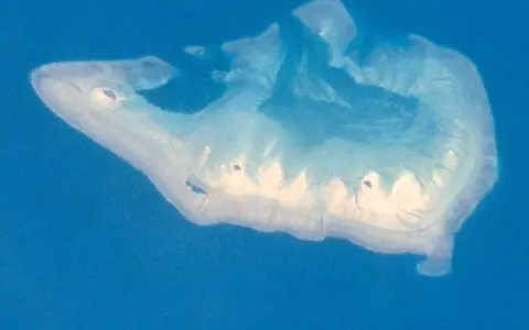

What Ashmore Reef is
Ashmore Reef is a large, shelf-edge carbonate platform with an emergent reef rim, reef flats, back-reef sand sheets, two lagoons, and low sandy islands. Although often described as oceanic because it is remote and surrounded by open sea, its foundation rises at the western limit of Australia's continental shelf.
Most of the landform remains at or below sea level. Reef flat accounts for roughly one-third of the reef, while back-reef sands occupy an even larger share. West, Middle, and East islands are the principal vegetated cays; the smaller Splittgerber Cay, also called Little East Island, is a shifting sand body east of the main islands.
Between northwest Australia and Indonesia
The reef is centered near 12° south and 123° east, about 610 kilometres north of Broome and 170 kilometres south of Rote in Indonesia. It lies far beyond the Kimberley coast, with no adjoining mainland and no river catchment supplying its lagoons.
Ashmore occupies the northwest edge of the Sahul Shelf, the submerged continental platform shared by northern Australia and New Guinea. Cartier Island lies roughly 45 kilometres to the southeast, while Hibernia Reef lies to the northeast. Beyond the shelf edge to the west, the seabed descends toward much deeper water of the Timor Trough region.
Outer rim, broad flats, and two lagoons
The exposed southern margin has the clearest reef crest because it faces prevailing waves and winds. There, the crest may stand above water during spring low tides, and a reef flat as much as two kilometres wide extends landward across coral pavement, boulders, sand, and shallow pools. The northern reef front is more sheltered and slopes through shallow coral growth into deeper shelf-edge water.
Sand accumulation behind the crest divides the interior into eastern and western lagoons. The eastern lagoon is about three times larger and generally 5–15 metres deep. The western lagoon is smaller but deeper, with maximum depths exceeding 25 metres. Channels and gaps across the northern side provide the main connections between both basins and the open sea.
Southern reef crest
Persistent wave exposure has built a prominent algal crest, boulder zone, and exceptionally broad intertidal flat.
Broad and shallow
The larger lagoon contains extensive shallow sand and reef surfaces and tends to hold more suspended sediment.
Smaller and deeper
The western lagoon descends beyond 25 metres and generally holds clearer water than the eastern basin.
Low cays above steep regional relief
The visible islands occupy only a minute part of the platform. They are loose accumulations of carbonate sand and rubble, reshaped by waves, currents, storms, and the movement of sediment across the reef flat. West Island is the largest, a little over one kilometre long; all the cays have low dune relief and changing shorelines.
Below them, the reef forms the cap of a much larger submarine rise at the Sahul Shelf margin. The platform top is mostly shallow and gently graded, but its outer edge marks a rapid transition toward the continental slope. This contrast—from low cay and intertidal flat to deep offshore water—is the principal relief pattern of Ashmore Reef.
Tides connect lagoons and open sea
Ashmore has no streams, permanent surface lakes, or mainland runoff. Rainfall can collect temporarily and infiltrate the porous cay sands, but seawater movement controls the reef as a whole. Tides alternately flood and expose the flats, while lagoon water passes through channels in the reef rim.
The two basins circulate differently because of their unequal area, depth, and connection to the sea. Wave-driven water crosses the exposed crest, tidal currents focus through openings, and calmer conditions allow fine carbonate sediment to remain suspended or settle in the eastern lagoon. Along the outer edge, shelf currents and internal tides interact with the abrupt seabed slope and mix deeper and shallower water.
Monsoon seasons and tropical storms
The reef has a tropical maritime climate shaped by the Australian monsoon. Westerly winds, greater cloud, and most rainfall occur during the warmer wet season; southeasterly trade winds and drier conditions dominate much of the cooler part of the year. With little land and negligible topographic relief, surrounding sea temperatures and seasonal wind fields strongly moderate local conditions.
Tropical cyclones can bring high waves, storm surge, and strong currents that move sand and coral rubble, cut or close channels, and alter cay shorelines. Regional waters are also influenced by flow from the Indonesian seas toward the eastern Indian Ocean. These currents link Ashmore to the Timor Sea and the wider North West Shelf while the shelf edge promotes local mixing.
A northern outlier of Australia's reef geography
Ashmore Reef sits in a chain of shallow carbonate highs near the outer Sahul Shelf. Cartier Island and Hibernia Reef share the same broad shelf-edge setting, while deeper passages isolate each platform. The reef's nearest geographic connections run north toward the Lesser Sunda Islands and southeast along Australia's North West Shelf rather than toward the distant mainland coast.
Within Geography Atlas, Ashmore belongs in the reef hub. Its broad platform and double lagoon contrast with the three separate atolls of the Rowley Shoals farther southwest, while the Kimberley Reefs show how reef form changes closer to a tide-dominated mainland coast.