One name, several geographic limits
Taurus Mountains is the accepted English name; Toros Dağları and the shorter Toroslar are Turkish forms. This record covers the broad southern Anatolian mountain system, but it distinguishes the Mediterranean-facing Western and Central Taurus from the Eastern Taurus and from the “Southeastern Taurus” convention used for ranges toward the Bitlis–Hakkâri highlands. A Turkish Mineral Research and Exploration paper, for example, places part of the Eastern Taurus in the Malatya–Adıyaman region, while the USGS glacier report uses Southeastern Taurus for a farther-eastern glaciated belt. (Yıldırım and others, 2021; Kurter and others, 1991)
A reference-work estimate of about 1,500 km describes the broad west–east name span through Anatolia, not a measured crest line or a legally delimited polygon. No authoritative whole-range area, width, centroid, or endpoint pair accompanies that estimate. This page therefore does not manufacture them, and it does not call Kızılkaya the highest point of every broader eastern definition. (Rice, 2015)
From the Antalya arc to the Cilician margin
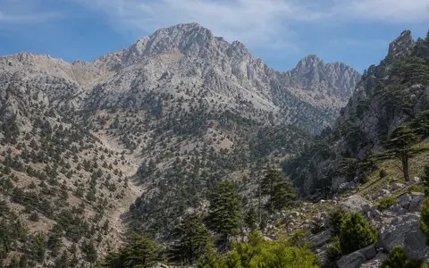
In the west, the mountains wrap around the Gulf of Antalya and stand between the Mediterranean coast, the Anatolian lake district, and interior uplands. Eastward, the Geyik and Taşeli uplands lead into the Central Taurus, where the Bolkar Mountains and Aladağlar rise between the Konya side of the plateau and the Mersin–Adana lowlands. The southern front is locally close to the sea but opens onto wider lowlands at Antalya and the Cilician Plain; the northern side merges into plateaus, fault corridors, and closed basins rather than ending at a single foothill line.
The Aladağlar provide a measured example of this compound relief, not dimensions for the whole Taurus. A 1:50,000 geomorphological study mapped a roughly 1,200 km² carbonate massif between 37°41′–38°01′ N and 35°01′–35°23′ E. It is bounded by the Ecemiş Fault corridor to the west and the Zamantı River to the east, with elevations in the mapped setting rising from about 400 m to above 3,750 m. (Köse and others, 2021)
Official Turkish publications disagree slightly on the highest summit of that massif. Niğde’s 2023–2026 strategic plan gives Kızılkaya as 3,767 m; a Ministry of National Education geography text, crediting the national mapping authority, gives 3,771 m. Neither source states the survey epoch, method, or vertical datum, so this page reports about 3,770 m and does not average the figures into a false precision. The same Niğde document gives nearby Medetsiz in the Bolkar Mountains as 3,524 m. (Niğde Provincial Directorate of Culture and Tourism; Ministry of National Education)
A former carbonate platform beneath oceanic thrust sheets
Much of the Tauride belt began as limestone and dolomite deposited on marine platforms and margins of the Neotethys oceans. During Late Cretaceous convergence, material generated above intra-oceanic subduction zones was emplaced across the Tauride carbonate platform. The resulting stack includes carbonate-platform rocks, sedimentary mélange, metamorphic soles, and ophiolites—fragments of oceanic crust and upper mantle carried onto continental rocks. This history is more specific than the loose label “fold mountain.” (Parlak, 2016)
The old thrust belt did not acquire all of its present elevation at one time. In a Central Taurus study area above the Cyprus subduction zone, dated fault calcites and structural measurements indicate normal faulting from the Middle or Late Pleistocene into the Holocene and about 1.5 km of surface uplift since 450,000 years ago. That quantified result applies to the studied Central Taurus margin, not automatically to every western or eastern subrange. It shows that uplift, extension, river incision, and karst development have continued to reorganize the inherited mountain structure. (Aykut and others, 2025)
Limestone and dolomite
Thick marine carbonate successions form many cliffs, high plateaus, and permeable massifs.
Ophiolites and mélange
Disrupted ocean-floor rocks and mixed sedimentary units were carried onto the platform during convergence.
Faulting and incision
Quaternary deformation and uplift continue to shape the Central Taurus plateau margin.
Drainage that does not stay on the surface
Rain and snowmelt absorb carbon dioxide and weak acids, then enlarge fractures as the water passes through limestone. Over time this creates karst: sinkholes, caves, sinking streams, springs, and internally drained depressions. A polje is a large, flat-floored closed depression in karst terrain; it may flood when inflow exceeds the capacity of swallow holes and underground conduits. These forms are especially conspicuous on Western and Central Taurus plateaus.
Not every cavity formed only by water descending from the surface. Hydrogeological research identifies hypogene karst produced by fluids rising from depth, including evidence from the Kırkgöz cave-and-spring system near Antalya and collapse depressions, or obruks, in the Central Taurides. Because water can cross beneath topographic ridges, a surface catchment boundary and a groundwater divide need not coincide. Large springs at mountain fronts can therefore integrate recharge from enclosed basins and high plateaus well beyond the immediately visible valley. (Bayarı and others, 2024)
Cold-stage ice over a karstic massif
The highest Central Taurus massifs preserve cirques, U-shaped valleys, arêtes, moraines, polished bedrock, and outwash fans from repeated Late Pleistocene glaciation. On the Aladağlar’s Yedigöller Plateau, an ice cap fed outlet glaciers, including the former Hacer Valley glacier, which extended about 15 km. These landforms sit on highly permeable carbonate bedrock, so glacial, periglacial, karstic, and river processes overlap rather than occupy separate landscapes. (Köse and others, 2021)
The same 2021 mapping identified 97 moraine polygons covering about 30 km² and mapped about 1.43 km² of debris-covered glacier remnants on and near Yedigöller. Those values belong to the study’s mapped Aladağlar inventory; they are not a current Taurus-wide glacier total. Debris can insulate buried ice, while rockfall, meltwater, frost shattering, and slope movement continue to modify the high valleys.
Short coastal rivers, plateau basins, and karst transfer
Southern catchments descend steeply toward the Mediterranean. The Manavgat drains part of the Antalya-facing karst, the Göksu crosses the Taşeli sector, and the Seyhan and Ceyhan gather water from higher central and eastern catchments before crossing the Cilician Plain. On the north side, drainage enters plateau rivers and interior depressions, including the Konya Closed Basin. Türkiye’s official 25-basin framework places the Taurus across or beside the West Mediterranean, Antalya, East Mediterranean, Seyhan, Ceyhan, Konya Closed, and adjoining basin units; these are hydrological management boundaries, not a definition of the mountains. (Turkish Water Institute, 2018)
Seasonal snow delays part of the high-elevation runoff until spring and early summer, but storage and release differ by altitude, aspect, and year. In karst sectors, water may disappear into a sink, move through a conduit, and return at a spring in another surface valley. Farther east, definitions that include the Eastern or Southeastern Taurus overlap headwater country of the Tigris–Euphrates system; that connection is kept separate from the better-defined Mediterranean and Central Anatolian drainage of the Western and Central Taurus.
Winter moisture, summer drought, and an interior contrast
Mediterranean air forced up the seaward slopes cools and produces orographic rain or snow. The lower coastal side has wet cool seasons and dry summers; higher ground is colder, holds snow longer, and can receive precipitation when nearby lowlands receive rain. North of the principal ridges, greater continentality and shelter from maritime air produce colder winters and generally lower precipitation, although local exposure and elevation matter as much as which side of a mapped crest a site occupies.
Two lowland city records illustrate the seasonal contrast but are not mountain averages. In the Turkish State Meteorological Service’s published tables, Mersin’s mean monthly precipitation is 162.7 mm in December and 7.3 mm in August; Konya’s corresponding values are 45.6 mm and 6.5 mm. The comparison shows a much wetter maritime winter and summer dryness on both sides. It must not be used to estimate precipitation on high ridges, where station elevation, exposure, snow undercatch, and local topography change the totals. (Mersin statistics; Konya statistics)
Plateau edge, coastal basins, and eastern transition
The Western and Central Taurus separate the Mediterranean shore from the Central Anatolian interior, but rivers, fault corridors, and passes interrupt the barrier. Mountain streams carry carbonate gravel and finer sediment into the Antalya and Cilician lowlands; at the same time, karst groundwater can bypass the visible drainage network. Northward, the mountains grade into plateau surfaces and closed depressions rather than a single continuous escarpment.
East of the Central Taurus, named tectonic and physiographic belts approach the Anatolian–Arabian collision zone. The terms Eastern Taurus, Southeastern Taurus, Anti-Taurus, and Bitlis–Zagros belt overlap differently among maps and disciplines, so this page treats that area as a transition instead of pretending the Taurus have one undisputed eastern endpoint. Use the mountain hub for the wider category, and compare the neighboring Zagros Mountains without merging the two named systems.
Data sources and publications
- Rice, C. M. “Taurus Mountains,” The Encyclopedia of Ancient History (2015). Source for the rounded 1,500 km west–east extent; the publication does not define a surveyed polygon, area, width, or centroid.
- Yıldırım, E., Yıldırım, N., Dönmez, C., and Günay, K. “Geology of the Yeşilyurt gold deposit: an example of low-angle normal fault related mineralization, Eastern Anatolia–Turkey,” Bulletin of the Mineral Research and Exploration 164 (2021), 261–279. Its national tectonic map distinguishes Western, Central, and Eastern Taurus; the study locates its Eastern Taurus sector in Malatya–Adıyaman.
- Kurter, A., Ferrigno, J. G., Young, J. A., and Case, H. L. Glaciers of the Middle East and Africa, U.S. Geological Survey Professional Paper 1386-G (1991), doi:10.3133/pp1386G. Source for the separate Southeastern Taurus usage in Turkish glacier geography; glacier observations are historical, not a current inventory.
- Niğde Provincial Directorate of Culture and Tourism. 2023–2026 Strategic Plan, p. 12. Official provincial source for Kızılkaya at 3,767 m and Medetsiz at 3,524 m; no survey method or vertical datum is stated.
- Republic of Türkiye Ministry of National Education. Coğrafya 10, Unit 1, p. 59 (accessed 30 August 2026). Gives Kızılkaya as 3,771 m and credits the General Directorate of Mapping; no survey method or datum is exposed on the page.
- Parlak, O. “The Tauride ophiolites of Anatolia (Turkey): A review,” Journal of Earth Science 27 (2016), 901–934. Tauride carbonate platform, mélange, metamorphic soles, oceanic lithosphere, subduction setting, and Late Cretaceous ophiolite emplacement.
- Aykut, T. and others. “Coeval upper crustal extension and surface uplift in the Central Taurides (Türkiye) above the Cyprus Subduction Zone,” Nature Communications 16, 3921 (2025). Central Taurus fault chronology, normal faulting, and 1.5 km of study-area uplift since about 450 ka.
- Köse, O., Sarıkaya, M. A., Çiner, A., and Yıldırım, C. “Glacial geomorphology of the Aladağlar, central Taurus Mountains, Turkey,” Journal of Maps 17(2) (2021), 101–113. Aladağlar bounds, mapped area and relief; 1:50,000 glacial geomorphology; Hacer paleoglacier length; moraine area; and mapped debris-covered ice.
- Bayarı, C. S., Özyurt, N. N., Nazik, L., Törk, K. A., Güner, N. İ., Pekkan, E., and Avcı, P. “Role of hypogenesis in the evolution of karst in the Taurus Mountains Range, Turkey,” International Journal of Speleology 53(2) (2024), 111–128. Kırkgöz, obruks, rising fluids, and the distinction between epigene and hypogene karst.
- Turkish Water Institute. Turkey and Water (2018), pp. 12–13. National 25-basin map and names, basin areas, and 1981–2010 mean-flow context; used here only to orient Taurus drainage among official basin units.
- Turkish State Meteorological Service. Mersin and Konya official climate statistics (accessed 30 August 2026). Monthly precipitation and temperature tables used as lowland maritime and interior examples, not as mountain-wide normals.